Unmanned aerial vehicle indoor navigation method, device, unmanned aerial vehicle and storage medium

An indoor navigation and unmanned aerial vehicle technology, applied in the field of unmanned aerial vehicle navigation, can solve the problem of low accuracy and efficiency of unmanned aerial vehicle autonomous navigation, and achieve the effect of reducing navigation cost, improving efficiency and small size

Active Publication Date: 2021-01-15
SHENZHEN INST OF ADVANCED TECH CHINESE ACAD OF SCI
View PDF7 Cites 0 Cited by
  • Summary
  • Abstract
  • Description
  • Claims
  • Application Information

AI Technical Summary

Problems solved by technology

[0006] The purpose of the present invention is to provide a method and device for indoor navigation of UAVs, UAVs and storage media, aiming to solve the problem of autonomous navigation of UAVs in indoor environments with weak or no GPS signals due to the inability of the prior art. Navigation accuracy and low efficiency

Method used


Image

  • Unmanned aerial vehicle indoor navigation method, device, unmanned aerial vehicle and storage medium
  • Unmanned aerial vehicle indoor navigation method, device, unmanned aerial vehicle and storage medium
  • Unmanned aerial vehicle indoor navigation method, device, unmanned aerial vehicle and storage medium

Examples


Embodiment 1

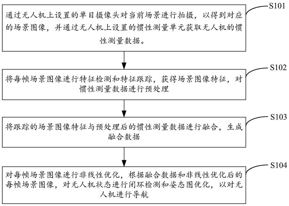
[0027] figure 1 It shows the implementation process of the UAV indoor navigation method provided by Embodiment 1 of the present invention. For the convenience of description, only the parts related to the embodiment of the present invention are shown, and the details are as follows:

[0028] In step S101, the current scene is photographed by a monocular camera set on the drone to obtain a corresponding scene image, and the inertial measurement data of the drone is obtained by an inertial measurement unit set on the drone.

[0029] In the embodiment of the present invention, the visual sensor provided on the drone is a monocular camera. In addition to the visual sensor, an inertial measurement unit (IMU, Inertialmeasurement unit) for inertial measurement of the drone is additionally set up on the drone. ), the inertial measurement data of the drone can be measured. The embodiment of the present invention combines the monocular camera with the inertial measurement unit to realiz...

Embodiment 2

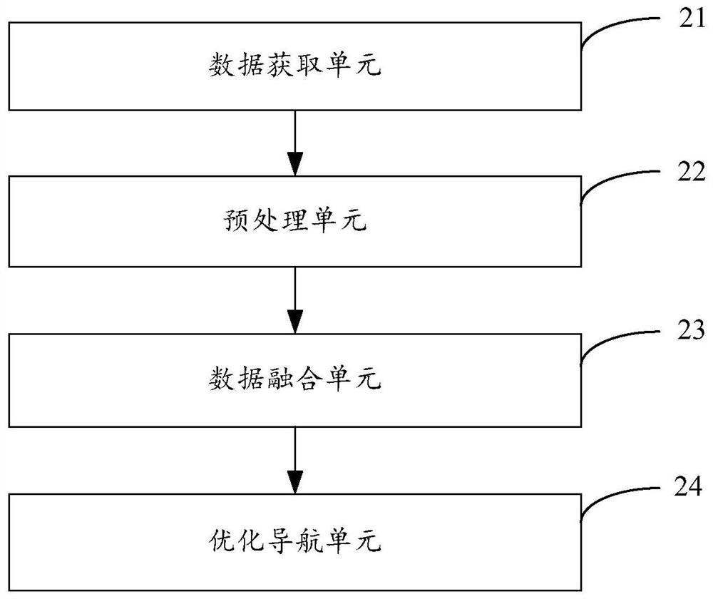
[0043] figure 2 The structure of the drone indoor navigation device provided by the second embodiment of the present invention is shown. For the convenience of description, only the parts related to the embodiment of the present invention are shown, including:

[0044] The data acquisition unit 21 is used to shoot the current scene through the monocular camera set on the drone to obtain the corresponding scene image, and acquire the inertial measurement data of the drone through the inertial measurement unit set on the drone.

[0045] In the embodiment of the present invention, the visual sensor set on the drone is a monocular camera. In addition to the visual sensor, an inertial side face unit for inertial measurement of the drone is set up on the drone, which can be measured to obtain For the inertial measurement data of the drone, the embodiment of the present invention realizes the autonomous navigation of the drone in an indoor environment where the global positioning si...

Embodiment 3

[0066] Figure 4 The structure of the drone provided by the third embodiment of the present invention is shown, and for the convenience of description, only the parts related to the embodiment of the present invention are shown.

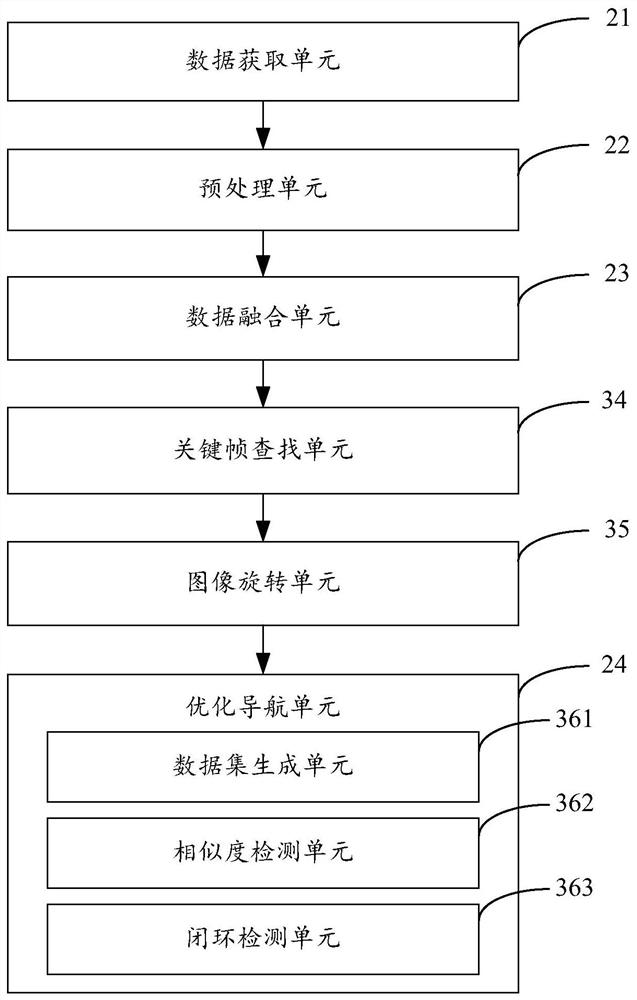
[0067] The drone 4 in the embodiment of the present invention includes a processor 40 , a memory 41 and a computer program 42 stored in the memory 41 and operable on the processor 40 . When the processor 40 executes the computer program 42, the steps in the above-mentioned method embodiments are realized, for example figure 1 Steps S101 to S104 are shown. Alternatively, when the processor 40 executes the computer program 42, the functions of the units in the above-mentioned device embodiments are realized, for example figure 2Function of units 21 to 24 shown.

[0068] In the embodiment of the present invention, the scene image is captured by the monocular camera on the drone, and the inertial measurement data is obtained by the inertial measureme...


PUM


Abstract

The invention is suitable for the technical field of computers, and provides a method and a device for indoor navigation of an unmanned aerial vehicle, the unmanned aerial vehicle and a storage medium. The method includes the following steps: photographing the current scene through a monocular camera arranged on the unmanned aerial vehicle to obtain corresponding scene images, acquiring the inertial measurement data of the unmanned aerial vehicle through an inertial measurement unit arranged on the unmanned aerial vehicle, preprocessing the inertial measurement data, combining tracked scene image characteristics with the preprocessed inertial measurement data to generate fusion data, nonlinearly optimizing every frame of the data, and carrying out closed loop detection and attitude graph optimization on the state of the unmanned aerial vehicle according to the fusion data and every frame of the nonlinearly optimized scene images in order to realize the navigation of the unmanned aerial vehicle. The method and the device have the advantages of realization of the automatic navigation of the unmanned aerial vehicle in the indoor environment with weak or no GPS signals, effective reduction of the navigation cost of the unmanned aerial vehicle, and improvement of the navigation accuracy and the precision efficiency of the unmanned aerial vehicle.

Description

technical field [0001] The invention belongs to the technical field of unmanned aerial vehicle navigation, and in particular relates to an indoor navigation method and device for an unmanned aerial vehicle, an unmanned aerial vehicle and a storage medium. Background technique [0002] With the improvement of embedded technology, sensor information fusion, navigation and control and other theories, quadrotor drones have developed rapidly. The quadrotor UAV is light in weight, small in load, and poor in endurance. Although it can fly in a small space thanks to its size advantage, its overall structure and performance also determine that it can only work at low altitude and short flight. Such as canyons, indoors, woods and other relatively closed environments. In such environments, the Global Positioning System (GPS) signal is generally weak, or there may be no GPS signal at all due to, for example, the structure of the building. It can be seen that the navigation of UAVs in ...

Claims


Application Information

Patent Timeline
Patent Type & Authority Patents(China)
IPC IPC(8): G01C21/16
CPCG01C21/165
Inventor 周翊民欧明华吕琴李志飞
Owner SHENZHEN INST OF ADVANCED TECH CHINESE ACAD OF SCI
Why Eureka
Try Eureka