Graphic animation design system based on three-dimensional digital earth and design method thereof

A 3D digital and design system technology, applied in animation production, calculation, image data processing, etc., can solve the problems of the 3D digital earth system lacking the ability to quickly construct animation scenes, unable to realize real-time adjustment of animation effects and animation processes, etc. Build and Modify Effects

Active Publication Date: 2017-12-19
THE 28TH RES INST OF CHINA ELECTRONICS TECH GROUP CORP
View PDF16 Cites 18 Cited by
  • Summary
  • Abstract
  • Description
  • Claims
  • Application Information

AI Technical Summary

Problems solved by technology

[0004] However, the existing 3D digital earth system lacks the ability to quickly construct animation scenes. It can only represent a specific situation

Method used


Image

  • Graphic animation design system based on three-dimensional digital earth and design method thereof
  • Graphic animation design system based on three-dimensional digital earth and design method thereof
  • Graphic animation design system based on three-dimensional digital earth and design method thereof

Examples


Embodiment 1

[0057] Taking the scenario of a missile attacking an aircraft as an example, the scenario construction in this embodiment can be realized through the following steps:

[0058] Step 1: Open the 3D Digital Earth, zoom in to the target airspace, click the "New Animation Project" menu, and specify the project storage name and location;

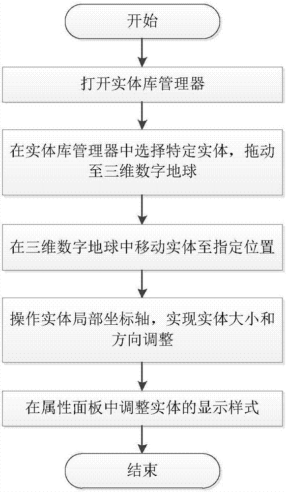
[0059] Step 2: Click the "Entity Library Manager" menu to pop up the entity library manager panel, select the "J-10" fighter jet in the panel, and drag it to the specified position. After the model is successfully deployed, the "Current "J-10" fighter jet is added to the "Model" list. Click on the "J-10" fighter jet in the list to display its property panel. You can adjust its alias, size, position, attitude and other property parameters according to your needs;

[0060] Step 3: Refer to step 2 to deploy enemy tanks, such as the Arjun main battle tank, and adjust their attributes; deploy the PL12 missile model;

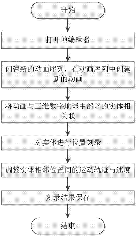
[0061] Step 4: Open the "Frame Ed...


PUM


Abstract

The invention discloses a graphic animation design system based on three-dimensional digital earth and a design method thereof. The system includes: a three-dimensional digital earth module, which provides capabilities of three-dimensional earth simulation and geographic information data management, display and analysis , and is a display platform of the entire system; an animation data management module, which manages data including graphic data and various types of script data, and is data support in an animation design process; a visual editing tool module, which includes an entity library manager, a frame editor and a flowchart editor, and is a human-machine interaction platform of the system; and an algorithm logic module, which provides underlying algorithm support, and is a technical basis of the system and an association link of all the parts of the modules. The system uses the three-dimensional digital earth as a display basis, adapts to various spatial scales, can realize rapid construction and modification of a three-dimensional animation scene in a local scene or a global range, and provides a rehearsal deployment platform for the fields of military exercises and the like.

Description

technical field [0001] The invention belongs to three-dimensional visualization simulation and geographic information information technology, and specifically relates to providing a graphic animation design system and a design method based on a three-dimensional digital earth. Background technique [0002] The 3D digital earth is based on massive geographic information data such as raster images, vectors, and DEM elevations. It can realize the visual expression of the earth's 3D multi-scale resolution and provide functions such as geographic information analysis. Combined with network, geographic information, virtual reality and other technologies, it can provide auxiliary analysis and auxiliary decision-making capabilities in many fields such as urban planning, homeland security, and combat exercises. 3D animation has the characteristics of vivid images, and is widely used in games, movies and other fields. [0003] At present, most of the existing 3D digital earth systems...

Claims


Application Information

Patent Timeline
IPC IPC(8): G06T13/60
CPCG06T13/60
Inventor 王辉占伟伟雷文书蒉露超周传龙
Owner THE 28TH RES INST OF CHINA ELECTRONICS TECH GROUP CORP
Why Eureka
Try Eureka