Remote sensing-based landslide mass volume estimation method

A landslide mass and volume technology, applied in the field of remote sensing, can solve the problems of lack of mathematical mechanism, low reliability of estimation results, and inability of estimation accuracy and estimation time to meet the needs of disaster emergency rescue, so as to save estimation time and improve estimation accuracy.

Active Publication Date: 2018-01-09
INST OF REMOTE SENSING & DIGITAL EARTH CHINESE ACADEMY OF SCI
View PDF4 Cites 7 Cited by
  • Summary
  • Abstract
  • Description
  • Claims
  • Application Information

AI Technical Summary

Problems solved by technology

However, this method lacks a mathematical mechanism, and the reliability of the estimation result of a single landslide volume is low, so it cannot be used for emergency rescue comm

Method used


Image

  • Remote sensing-based landslide mass volume estimation method
  • Remote sensing-based landslide mass volume estimation method
  • Remote sensing-based landslide mass volume estimation method

Examples


Embodiment 1

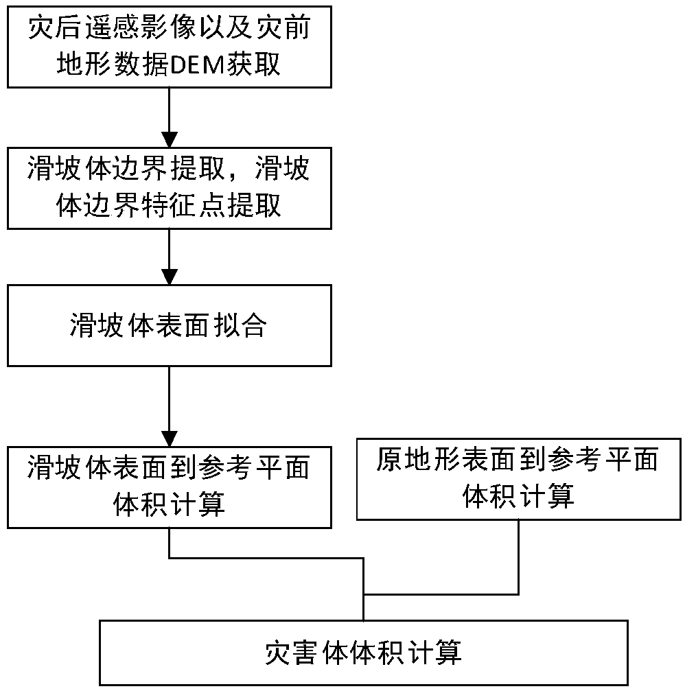
[0033] When a (single) landslide occurs, the landslide body forms an interactive surface with the original topography. Multiple feature points with the same elevation value as the original terrain can be extracted on the boundary of the interaction surface. In this case, the three-dimensional surface of the landslide body can be fitted based on these feature points, and then the volume of the landslide body can be estimated by calculating the volume difference between the fitted surface and the original terrain surface. The specific method steps are as figure 1 shown.

[0034] S1. Obtain the post-disaster remote sensing images of the landslide area to be estimated and the pre-disaster terrain data DEM. The boundaries of disaster volumes can be manually identified and drawn based on post-disaster images. Post-disaster images can be obtained by satellite remote sensing images, aerial remote sensing images and other means. Based on the emergency data sharing mechanism for maj...

Embodiment 2

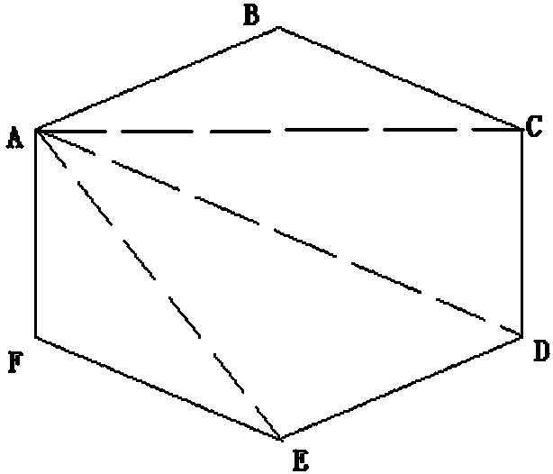
[0044] Based on S3 in the above method, a specific example is provided in the embodiment of the present invention, such as figure 2 As shown, the landslide boundary feature points include feature point A, feature point B, feature point C, feature point D, feature point E and feature point F, and then the triangle formed by the landslide mass boundary feature points includes triangle ABC, triangle ACD, The triangle ADE and the triangle AEF use the triangle ABC, the triangle ACD, the triangle ADE and the triangle AEF to form the fitted landslide body surface.

[0045] The sum of the volumes of the triangular prisms formed by the triangle ABC, the triangle ACD, the triangle ADE and the triangle AEF respectively and the reference plane is the volume between the calculated and fitted landslide body surface and the reference plane.

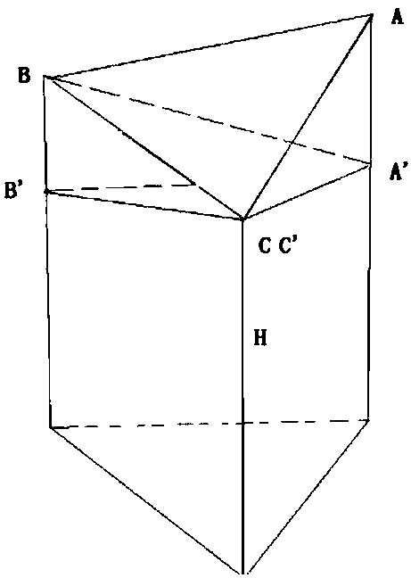
[0046] When the reference plane is a horizontal plane, the triangle ABC, such as image 3As shown, where point C is the lowest point, A' and B' are t...

Embodiment 3

[0050] Rapid extraction of landslide volume such as Figure 4 shown. The tool includes functions such as interactive drawing of landslide mass boundaries, drawing of landslide mass feature points, and calculation of landslide mass volume. The Tangjiashan landslide formed by the Wenchuan Earthquake was taken as a case for verification. Due to the "5.12" earthquake in Wenchuan, a high-speed landslide was formed in the Tangjiashan area on the right bank of the Tongkou River and blocked the river. The plane shape of the formed barrier dam is long. The data shows that the length of the barrier dam along the river is 803.4m, and the maximum width across the river is 611.8m. Compared with the original river bed elevation, the height of the barrier dam is 82-124m, and the area of ​​the blocked river is about 3×10⁵m 2 , the estimated volume is 20.37×10 6 m 3 . Such as Figure 4 As shown in , the boundary of the Tangjiashan landslide is delineated using the hazard volume boundary ...


PUM


Abstract

The invention discloses a remote sensing-based landslide mass volume estimation method. The method is characterized by comprising the steps of obtaining a post-disaster remote sensing image and a pre-disaster terrain data DEM of a to-be-estimated landslide mass region; performing boundary extraction on the landslide mass region in the post-disaster remote sensing image, and extracting and obtaining feature points of a landslide mass boundary; selecting a reference plane; based on the feature points of the landslide mass boundary, performing surface fitting on a landslide mass to obtain a fitted landslide mass surface, and calculating the volume between the fitted landslide mass surface and the reference plane; according to the DEM, extracting an original terrain surface, and calculating the volume between the original terrain surface and the reference plane; and fitting a difference between the volume between the landslide mass surface and the reference plane, and the volume between the original terrain surface and the reference plane to serve as a landslide mass volume. According to the method, the estimation precision of the landslide mass volume can be improved, so that the estimation time is greatly shortened.

Description

technical field [0001] The invention relates to the technical field of remote sensing, in particular to a method for estimating the volume of a landslide body based on remote sensing. Background technique [0002] Landslides are a common natural disaster triggered by earthquakes, rainfall, melting ice and snow, etc. In major natural disasters such as earthquakes, a large number of landslides are often caused, directly threatening human life and property safety. Landslides can block traffic, form barrier lakes, etc., hindering emergency rescue of disasters. Therefore, how to deal with landslides and the potential dangers they bring is one of the challenges in emergency rescue of major natural disasters. [0003] According to different needs, there are many methods to calculate the volume of landslide mass. According to geological drilling (geological drilling), high density resistivity (High density resistivity HDR), ground penetrating radar (ground penetrating radar, GPR)...

Claims


Application Information

Patent Timeline
IPC IPC(8): G06T7/62
Inventor 宇林军刘亚岚
Owner INST OF REMOTE SENSING & DIGITAL EARTH CHINESE ACADEMY OF SCI
Why Eureka
Try Eureka