Urban green land extracting method cooperating with multisource remote-sensing image

A technology for remote sensing images and extraction methods, which is applied in the fields of instrument, calculation, character and pattern recognition, etc., can solve the problems of low resolution and cannot meet the accuracy requirements, and achieve the effect of improving accuracy and realizing fast and accurate extraction.

Active Publication Date: 2018-02-13
TONGJI UNIV
View PDF9 Cites 9 Cited by
  • Summary
  • Abstract
  • Description
  • Claims
  • Application Information

AI Technical Summary

Problems solved by technology

The current research and application of urban green space is mainly based on multi-spectral remote sensing images. Since multi-spectral remote sensing images

Method used


Image

  • Urban green land extracting method cooperating with multisource remote-sensing image
  • Urban green land extracting method cooperating with multisource remote-sensing image
  • Urban green land extracting method cooperating with multisource remote-sensing image

Examples


Embodiment Construction

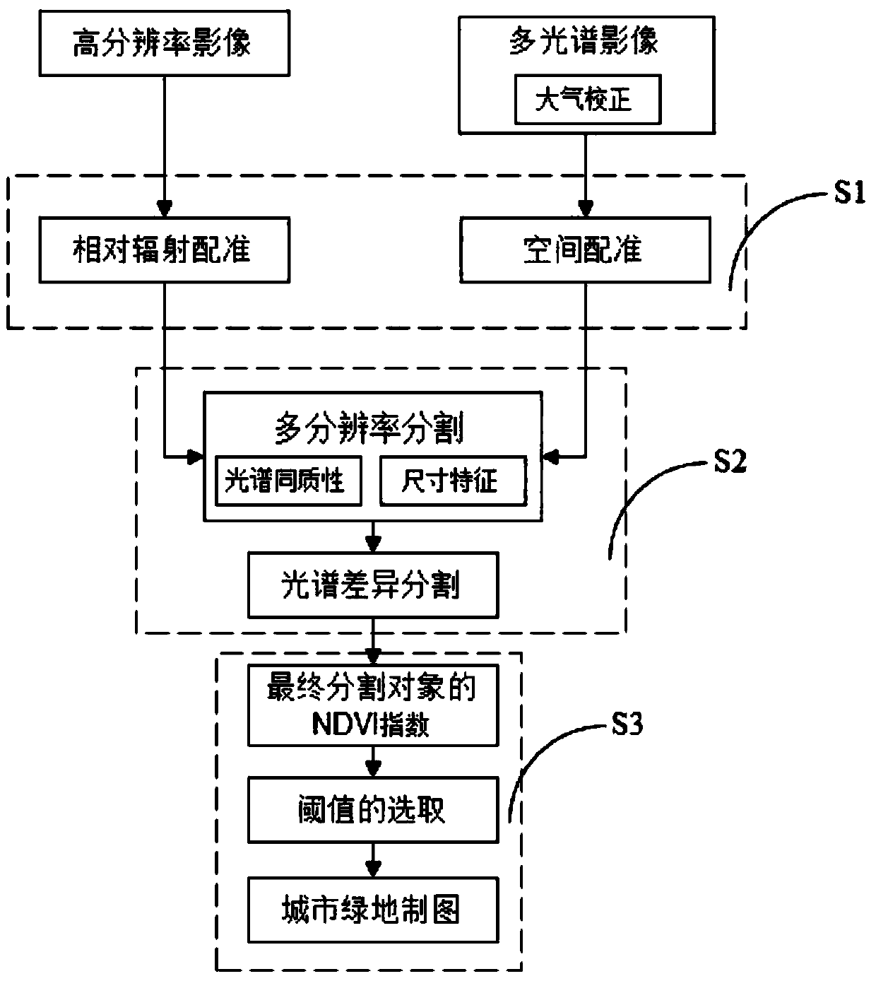
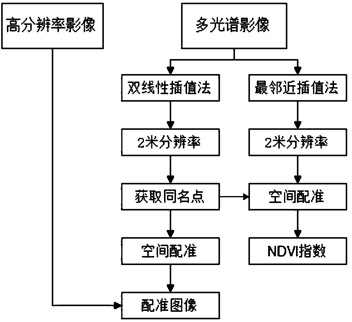
[0047] The present invention will be described in detail below in conjunction with the accompanying drawings and specific embodiments. This embodiment is implemented on the premise of the technical solution of the present invention, and detailed implementation and specific operation process are provided, but the protection scope of the present invention is not limited to the following embodiments.

[0048] The invention provides a method for extracting urban green space in cooperation with multi-source remote sensing images, which can quickly and accurately extract information on urban green space, and can accurately prepare urban green space mapping, so as to overcome the defects of the prior art. In this embodiment, the method for extracting urban green spaces in collaboration with multi-source remote sensing images includes a high-resolution image acquisition part and a multi-spectral image acquisition part. Multispectral imagery formed from the imagery.
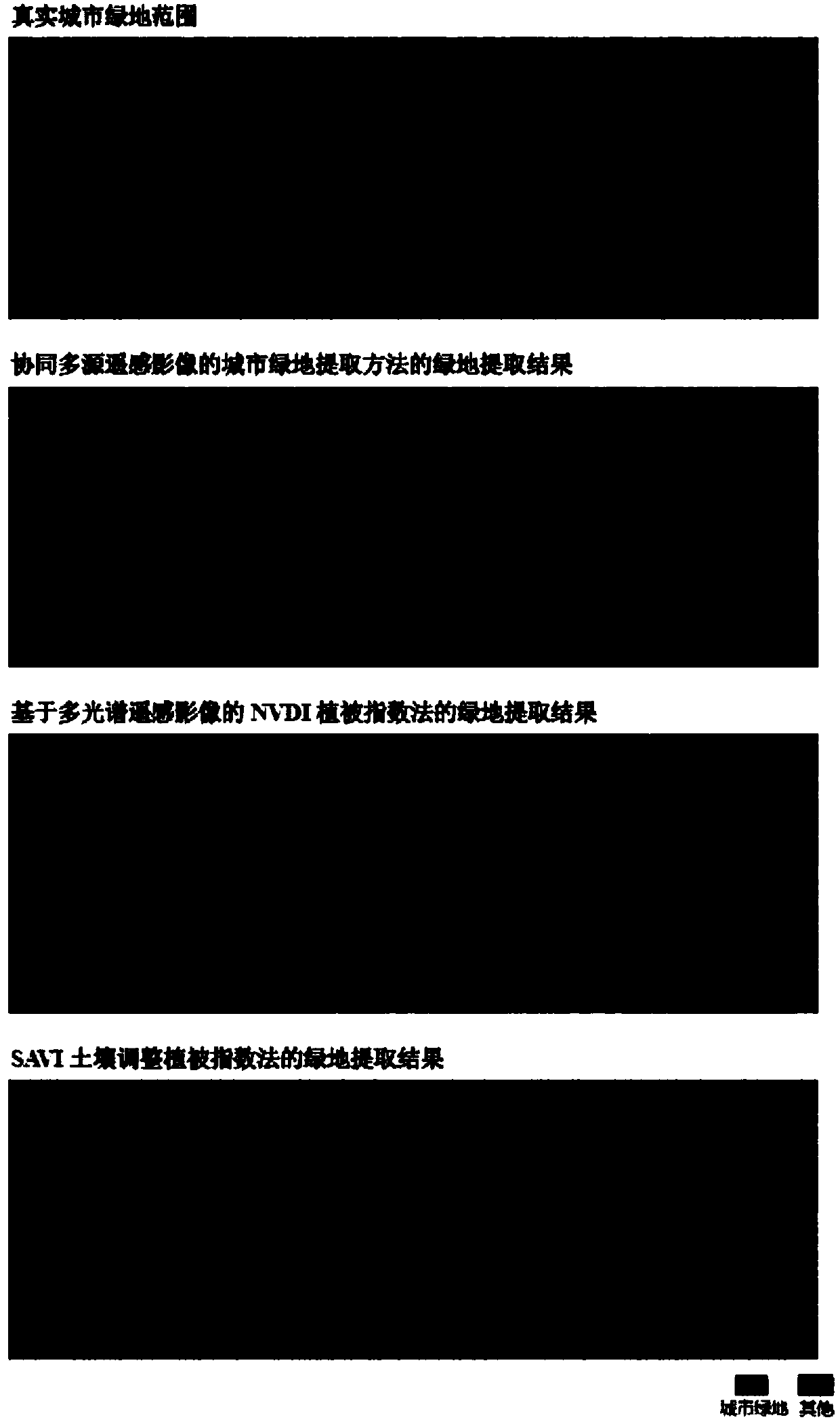
[0049] like fig...


PUM


Abstract

The invention relates to an urban green land extracting method cooperating with a multisource remote-sensing image. The method comprises the following steps that S1, a high-resolution image and a multispectral image are collected, image registering is carried out, the registered images are stacked, and a stacked image is obtained; S2, the stacked image is subjected to image segmentation based on the ground object space-spectrum features of the stacked image in S1, and a final segmented object is obtained; S3, vegetation spectral indexes are constructed through spectral information in the multispectral image based on the final segmented object in S2, a threshold value is selected, urban green land information is obtained, and drawing is carried out. Compared with the prior art, the urban green land condition can be extracted fast and accurately, drawing is carried out, and the method can be widely applied to the fields of urban planning, urban environment assessment and the like and isbeneficial to urban planning and development of the environmental protection cause.

Description

technical field [0001] The present invention relates to the field of image information extraction methods, in particular to a method for extracting urban green spaces in collaboration with multi-source remote sensing images. Background technique [0002] Urban green space has the advantages of purifying air, water and soil, improving urban climate, and reducing urban noise. In engineering applications such as urban landscape planning and urban ecological environment assessment, the accurate extraction and mapping of urban green space is essential for the analysis and decision-making of urban construction. All appear to be important. Due to the development of aerospace, remote sensing images with different spatial resolutions and different spectral resolutions have been obtained. The multi / hyperspectral remote sensing images are rich in spectral information, which can be distinguished by using the spectral characteristics of different ground objects. It is still difficult t...

Claims


Application Information

Patent Timeline
IPC IPC(8): G06K9/00G06K9/34
CPCG06V20/194G06V20/188G06V10/267
Inventor 童小华罗新赵文明柳思聪潘海燕刘世杰金雁敏
Owner TONGJI UNIV
Why Eureka
Try Eureka