
Airborne miniature laser radar three-dimensional plotting apparatus

A surveying and mapping device and laser radar technology, applied in the field of remote sensing surveying and mapping, can solve the problems of inconvenient connection, large size, and inability to respond quickly to surveying and mapping tasks, and achieve the effects of beautiful overall structure, high three-dimensional measurement accuracy, and flexible application.

Pending Publication Date: 2018-03-02
MIANYANG SKYEYE LASER TECH
View PDF0 Cites 8 Cited by
  • Summary
  • Abstract
  • Description
  • Claims
  • Application Information

AI Technical Summary

Problems solved by technology

[0009] The present invention provides an airborne miniature laser radar three-dimensional surveying and mapping device. The total weight is controlled below 6.5kg, and the lightest can reach 3kg. Questions about mapping tasks

Method used


Image

  • Airborne miniature laser radar three-dimensional plotting apparatus
  • Airborne miniature laser radar three-dimensional plotting apparatus

Examples


Embodiment Construction

[0031] The technical solutions in the embodiments of the present invention will be clearly and completely described below with reference to the accompanying drawings in the embodiments of the present invention, and the described embodiments are only a part of the embodiments of the present invention, rather than all the embodiments. Based on the embodiments of the present invention, all other embodiments obtained by those of ordinary skill in the art without creative efforts shall fall within the protection scope of the present invention.

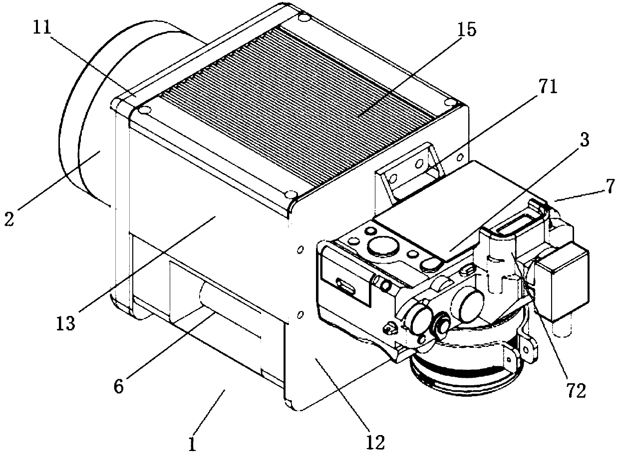
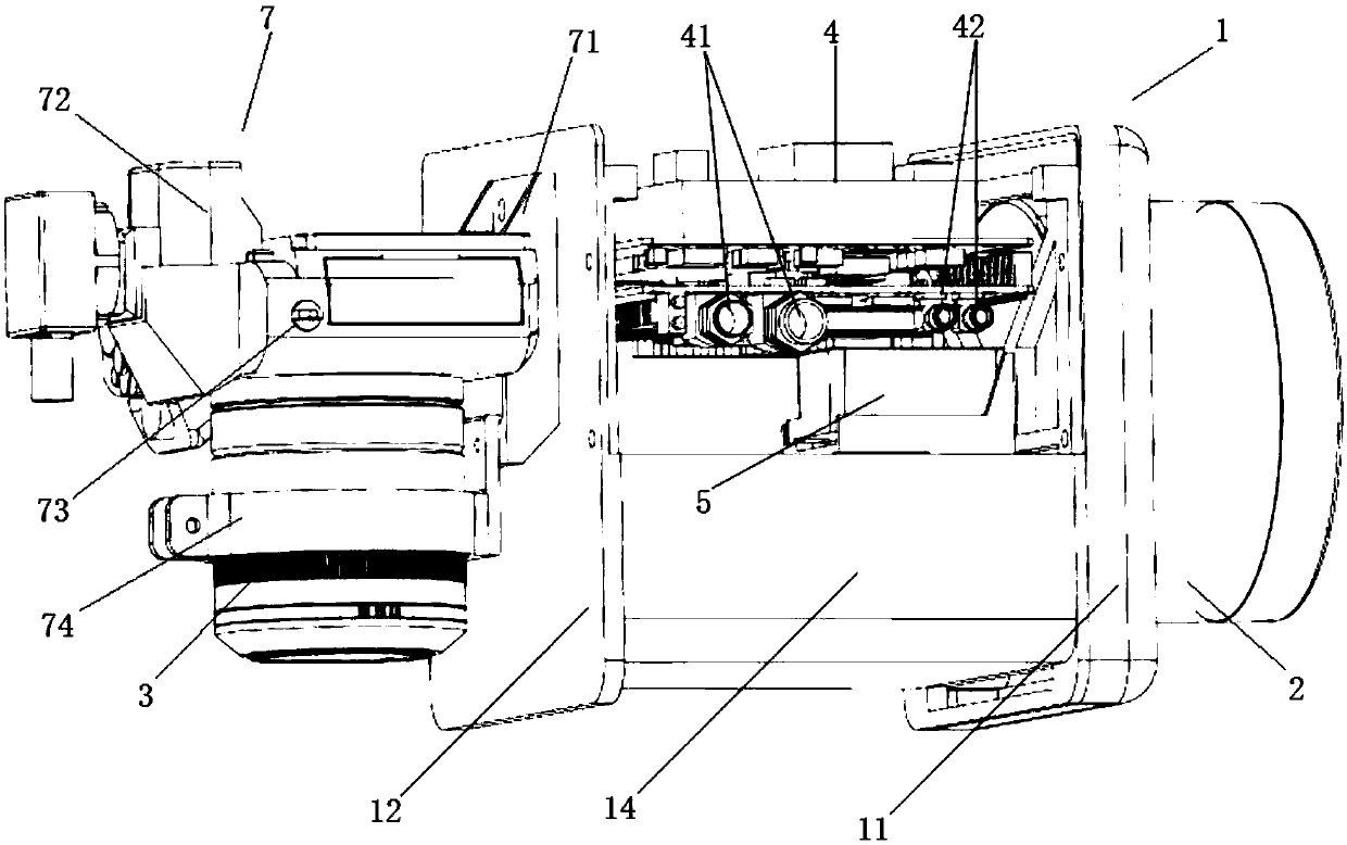
[0032] see figure 1 as well as figure 2, the embodiment of the present invention provides an airborne miniature laser radar three-dimensional surveying and mapping device, which mainly carries an aircraft, including a casing 1, a laser scanner 2 and a high-resolution digital camera 3, wherein the laser scanner 2 is partially installed and fixed on the casing 1. On one of the outer surfaces, the high-resolution digital camera 3 is installe...


PUM


Abstract

The invention relates to a laser radar and provides an airborne miniature laser radar three-dimensional plotting apparatus. The apparatus comprises a laser scanner, a high-resolution digital camera, alaser scanner and a shell. The laser scanner is partially installed on and is fixedly arranged on one external surface of the shell. The high-resolution digital camera is arranged on another externalsurface of the shell. A partial structure of the laser scanner, an embedded computer and an inertial measurement instrument are arranged in the shell. A global satellite positioning system and a storage module are arranged in the embedded computer. In the invention, the laser scanner and the digital camera are located at two opposite ends of an outer side of the shell respectively; the inertial measurement instrument, the partial structure of the laser scanner, the embedded computer and the like are arranged in the shell, and an integrated level is high; an integral structure of the plottingapparatus is guaranteed to be beautiful and an aircraft is convenient to carry the apparatus; advantages that an application is flexible, three-dimensional measurement precision is high, a topographyunder vegetations is acquired, autonomous navigation and height variation flight are achieved and so on; and the apparatus can be used for high-precision three-dimensional topography plotting of hillsand mountain areas.

Description

technical field [0001] The invention belongs to the field of remote sensing surveying and mapping, in particular to an airborne miniature laser radar three-dimensional surveying and mapping device. Background technique [0002] LiDAR system is an active measurement system that integrates laser ranging technology, global satellite positioning technology, inertial navigation technology, high-resolution digital imaging technology and computer technology to quickly obtain three-dimensional information of terrain and objects. In the past two decades, airborne LiDAR technology has been widely accepted around the world as an accurate and fast way to obtain three-dimensional surface information. , smart city construction and many other fields have a wide range of application needs and broad development prospects. [0003] The airborne lidar system is generally composed of laser scanners, aerial survey cameras, positioning and attitude systems and core storage modules. By carrying t...

Claims


Application Information

Patent Timeline
IPC IPC(8): G01S17/89G01S7/481
CPCG01S7/4817G01S17/89
Inventor 窦延娟陈小风唐海龙钱天龙潘文武唐丹黄贵余蒋浩黄仁兵
Owner MIANYANG SKYEYE LASER TECH
Learn More