
Video monitoring-based navigation planning system

A planning system and video monitoring technology, applied in the navigation field, to achieve the effect of saving construction costs, ensuring reliability, and saving construction costs

Inactive Publication Date: 2018-03-06
SICHUAN JIUDINGZHIYUAN INTPROP OPERATIONS CO LTD
View PDF10 Cites 2 Cited by
  • Summary
  • Abstract
  • Description
  • Claims
  • Application Information

AI Technical Summary

Problems solved by technology

[0005] The purpose of the present invention is to: address the above existing problems, provide a traffic road condition analysis solution based on the existing monitoring network without the user actively uploading traffic data, so as to solve the navigation problem for the user

Method used


Image

  • Video monitoring-based navigation planning system
  • Video monitoring-based navigation planning system
  • Video monitoring-based navigation planning system

Examples


Embodiment Construction

[0037] All features disclosed in this specification, or steps in all methods or processes disclosed, may be combined in any manner, except for mutually exclusive features and / or steps.

[0038] Any feature disclosed in this specification (including any appended claims, abstract), unless otherwise stated, may be replaced by alternative features that are equivalent or serve a similar purpose. That is, unless expressly stated otherwise, each feature is one example only of a series of equivalent or similar features.

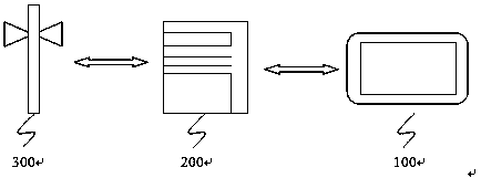
[0039] Such as figure 1 As shown, this embodiment discloses a navigation planning system based on video monitoring, including: a terminal, a server, and a monitoring device that are sequentially connected to each other by signals, wherein:

[0040] A terminal, configured to send a navigation request to the server; and receive a navigation planning solution sent by the server;

[0041] The server receives the navigation request from the terminal, and obtains the sta...


PUM


Abstract

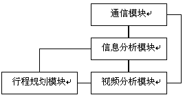
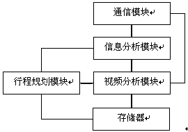
The invention discloses a video monitoring-based navigation planning system. The video monitoring-based navigation planning system comprises a terminal, a server and monitoring equipment which are insignal connection with each other sequentially, wherein the terminal transmits a navigation request to the server and receives a navigation plan scheme transmitted by the server; the server receives the navigation request of the terminal and acquires a starting point and a terminal point of journey according to the navigation request; the server acquires a monitoring video acquiring request transmitted by the monitoring equipment in the corresponding area, establishes a traffic model according to the monitoring video fed back by the monitoring equipment and predicts the time required by each road section; the server selects the road section with the shortest total time consumption and establishes a navigation plan scheme; and the monitoring equipment is used for receiving the monitoring video acquiring request of the server and feeds back the monitoring video according to the monitoring video acquiring request. The server comprises a communication module, an information analysis module, a video analysis module, a journey planning module and a memorizer. The video monitoring-based navigation planning system performs personalized journey planning on a user based on the monitoring video.

Description

technical field [0001] The invention relates to the field of navigation, in particular to a navigation planning system based on video surveillance. Background technique [0002] With the rapid development of the economy and the continuous improvement of national income, the infrastructure, especially the construction of the road traffic network, is also constantly improving and enriching. For individuals, it is impossible to remember all the roads. For unknown roads, generally through Consult the map or ask passers-by to get the route, but it is impossible to watch the map at any time while driving, and the speed of road construction must be higher than the speed of map publication, and the map cannot cover the entire transportation network. [0003] Traditional navigation equipment can basically cover the existing traffic network by updating data from time to time, thus solving most of the navigation problems. However, this type of device does not have the ability to refer...

Claims


Application Information

Patent Timeline
Patent Type & Authority Applications(China)
IPC IPC(8): G01C21/34G08G1/0968
CPCG01C21/3492G08G1/096816G08G1/096838
Inventor 罗艳
Owner SICHUAN JIUDINGZHIYUAN INTPROP OPERATIONS CO LTD
Learn More