GNSS/SINS combined navigation precise speed measurement and positioning method and system

A technology of combined navigation and positioning method, which is applied in the application field of inertial technology, can solve the problems such as the inability to accurately measure the speed of the train, and achieve the effect of overcoming GNSS's susceptibility to interference, high long-term accuracy, and improved accuracy

Inactive Publication Date: 2018-04-10
HUNAN AEROSPACE ELECTROMECHANICAL EQUIP & SPECIAL MATERIAL INST
View PDF7 Cites 31 Cited by
  • Summary
  • Abstract
  • Description
  • Claims
  • Application Information

AI Technical Summary

Problems solved by technology

[0004] The present invention aims to provide a GNSS / SINS integrated navigation and accurate speed measurement and positioning method to solve the problem that the traditional speed measurement method cannot accurately measure the speed of the traditional train without physical wheels and rails.

Method used


Image

  • GNSS/SINS combined navigation precise speed measurement and positioning method and system
  • GNSS/SINS combined navigation precise speed measurement and positioning method and system
  • GNSS/SINS combined navigation precise speed measurement and positioning method and system

Examples


Embodiment Construction

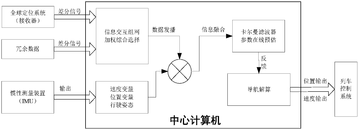
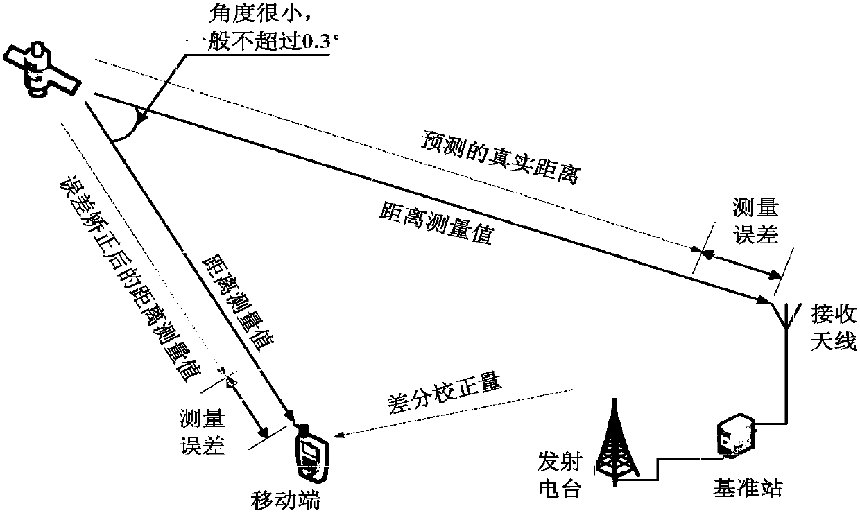
[0026] The GNSS / SINS combined navigation technology of the present invention adopts an integrated coupling design, and combines two simple navigation means of inertial navigation and satellite navigation. The current speed and position information given by the inertial navigation system is used as the main navigation system, and the classic Kalman filter algorithm is used for real-time feedback correction of the data, and the online zero position parameter estimation and zero speed correction functions are integrated into the two systems. Make corrections. The satellite signal base station adopts differential satellite information networking technology, and according to the dynamic matching algorithm of satellite reference stations, automatically selects the optimal matching reference station for user equipment to ensure the highest accuracy of satellite positioning. The receiver of the present invention does not need to track the signal, and integrates the navigation data out...


PUM


Abstract

The invention discloses a GNSS/SINS combined navigation precise speed measurement and positioning method and system. Navigation data output by SINS and GNSS is fused, the signal tacking process and data fusion are real-time synchronous, the obtained data is the most accurate at any time, and by fully utilizing the advantages that the SINS is high in short-term precision, outside interference doesnot exist, and the GNSS is high in long-term precision, the defects that the SINS is low in long-term precision, and the GNSS is likely to be interfered are overcome; the precision of speed measurement and positioning is improved, and the problem that a solid wheel rail free traditional train adopts a traditional speed measurement method, and then the train speed cannot be measured precisely is solved; strong support is formed for rapid development of the maglev train industry, and meanwhile development of the Beidou satellite application industry is driven, and the method and system can be promoted in rail transportation such as automatic driving or self-driving.

Description

technical field [0001] The invention belongs to the field of inertia technology application. In particular, it relates to an inertial integrated navigation technology that can be used in urban rail transit and automatic driving. Background technique [0002] After the opening of Changsha Maglev Project, the first maglev line with independent property rights in China, problems of inaccurate low-speed speed measurement and inaccurate parking positioning were found during operation. When the maglev train is running, the body is suspended on the track, and there is no mechanical contact between the train and the track except for the power supply rail. Therefore, the speed measurement technology of "axle pulse sensor", "axle counting" and "beacon" based on mechanical contact on the traditional train is used in the maglev train. In the environment where the train has no physical wheels and rails, the speed of the maglev train cannot be accurately measured, which affects the accur...

Claims


Application Information

Patent Timeline
Patent Type & Authority Applications(China)
IPC IPC(8): G01C21/16G01C25/00G01S19/47G01S19/50
CPCG01C21/165G01C25/005G01S19/47G01S19/50
Inventor 谢劲励刘三湘彭锦波谢松霖阳卫平金莹
Owner HUNAN AEROSPACE ELECTROMECHANICAL EQUIP & SPECIAL MATERIAL INST
Why Eureka
Try Eureka