Triangular grid reverse time migration method under mountainous terrain conditions

A triangular grid, reverse time migration technology, applied in seismology, geophysical measurement, seismic signal processing and other directions, to achieve the effect of strong operability, obvious imaging advantages, good flexibility and adaptability

Inactive Publication Date: 2018-04-20
CHINA UNIV OF PETROLEUM (EAST CHINA)
View PDF2 Cites 4 Cited by
  • Summary
  • Abstract
  • Description
  • Claims
  • Application Information

AI Technical Summary

Problems solved by technology

However, there are still few papers and applications on RTM based on the surface conditions of mountainous areas.

Method used


Image

  • Triangular grid reverse time migration method under mountainous terrain conditions
  • Triangular grid reverse time migration method under mountainous terrain conditions
  • Triangular grid reverse time migration method under mountainous terrain conditions

Examples


Embodiment Construction

[0016] The present invention will be described in detail below in conjunction with the accompanying drawings and embodiments.

[0017] The present invention proposes the triangular grid reverse time migration method under the surface condition of mountainous area, and it is characterized in that:

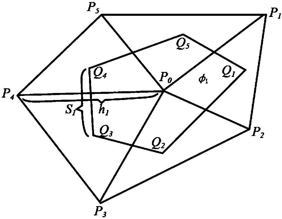
[0018] The scheme of model subdivision is as follows: the geological area involved in the migration is subdivided with triangular grids, and there is no overlapping area or blank area between the triangular grids. After the subdivision is completed, the model becomes a collection of a large number of triangular meshes, and each node may be a common vertex of multiple triangles. Multiple triangular meshes with common vertices constitute a computational unit, which is a polygon. For example in figure 1 , with a common vertex p 0 The five triangles of form a computational unit, namely the pentagon as shown. The center of gravity of each triangle in the calculation unit is taken, an...


PUM


Abstract

The invention relates to a triangular grid reverse time migration method under mountainous terrain conditions. The triangular grid reverse time migration method is characterized in that the process ofmodel subdivision is that a geological region involved in the migration is subdivided using triangular grids, with no overlapping or and blank regions among the triangular grids; after the subdivision is completed, the model becomes an aggregation of a large number of triangular grids, each node may be the common vertex of multiple triangles; multiple triangular grids with the common vertex constitute a computing unit which is a polygon; and the center of gravity is obtained for each triangle in the computing unit, and the centers of gravity of the triangles are connected to form a new polygon, and the new polygon is a dual unit of the computing unit.

Description

technical field [0001] The invention relates to a method for reverse time migration of triangular grids under surface conditions in mountainous areas, and belongs to the technical field of migration imaging of seismic data for oil and gas exploration. Background technique [0002] The low quality of seismic data in western exploration areas in China has always been a difficulty in processing. The drastic surface elevation change and the change of the low-velocity zone below the surface make the seismic data obviously different from the situation of plain exploration and acquisition. Conventional field elevation static correction methods use small refraction or micro-logging experiments to obtain approximate near-surface velocities, so as to correct seismic data for time difference and eliminate the influence of elevation changes on seismic data travel time. Under the complex surface topography conditions exposed by high-speed rock mass, the irregular surface will cause stro...

Claims


Application Information

Patent Timeline
Patent Type & Authority Applications(China)
IPC IPC(8): G01V1/36
CPCG01V1/36G01V2210/51
Inventor 孙小东贾延睿宋煜依尔繁
Owner CHINA UNIV OF PETROLEUM (EAST CHINA)
Why Eureka
Try Eureka