Pseudo-GPS-based landslide monitoring and early warning device and early warning method

A monitoring and early warning and equipment technology, applied in the field of electronic equipment, can solve the problems of decreased positioning accuracy, unstable signal transmission accuracy rate, long transmission time, etc., and achieve high accuracy rate and real-time and effective communication

Pending Publication Date: 2018-05-08
GUILIN UNIV OF ELECTRONIC TECH
View PDF6 Cites 3 Cited by
  • Summary
  • Abstract
  • Description
  • Claims
  • Application Information

AI Technical Summary

Problems solved by technology

[0002] Traditional landslide monitoring models such as figure 1 , figure 2 As shown, most of the current landslide monitoring systems use GPS and Beidou satellites for information transmission. Due to the long distance of signal transmission, the transmission takes a long time, making it difficult to provide effective real-time early warning; traditional GPS and Beidou satellites are used for information transmission. When the signal passes through the interference of the atmosphere, the weather is different and the interference of the atmosphere is different, which leads to the obvious instability of the accuracy of signal transmission. Therefore, the positioning accuracy of the traditional landslide monitoring and early warning system is low.
[0003] In view of the fact that the number of visible stars tracked by GPS in urban high-rise dense areas, deep mountains and canyons is small and poorly distributed, resulting in a decrease in positioning accuracy, and the GPS system itself has poor positioning accuracy in the vertical direction, a new GPS-pseudo-satellite combined positioning method is proposed. , using pseudolite-enhanced GPS technology to improve positioning accuracy

Method used


Image

  • Pseudo-GPS-based landslide monitoring and early warning device and early warning method
  • Pseudo-GPS-based landslide monitoring and early warning device and early warning method
  • Pseudo-GPS-based landslide monitoring and early warning device and early warning method

Examples


Embodiment

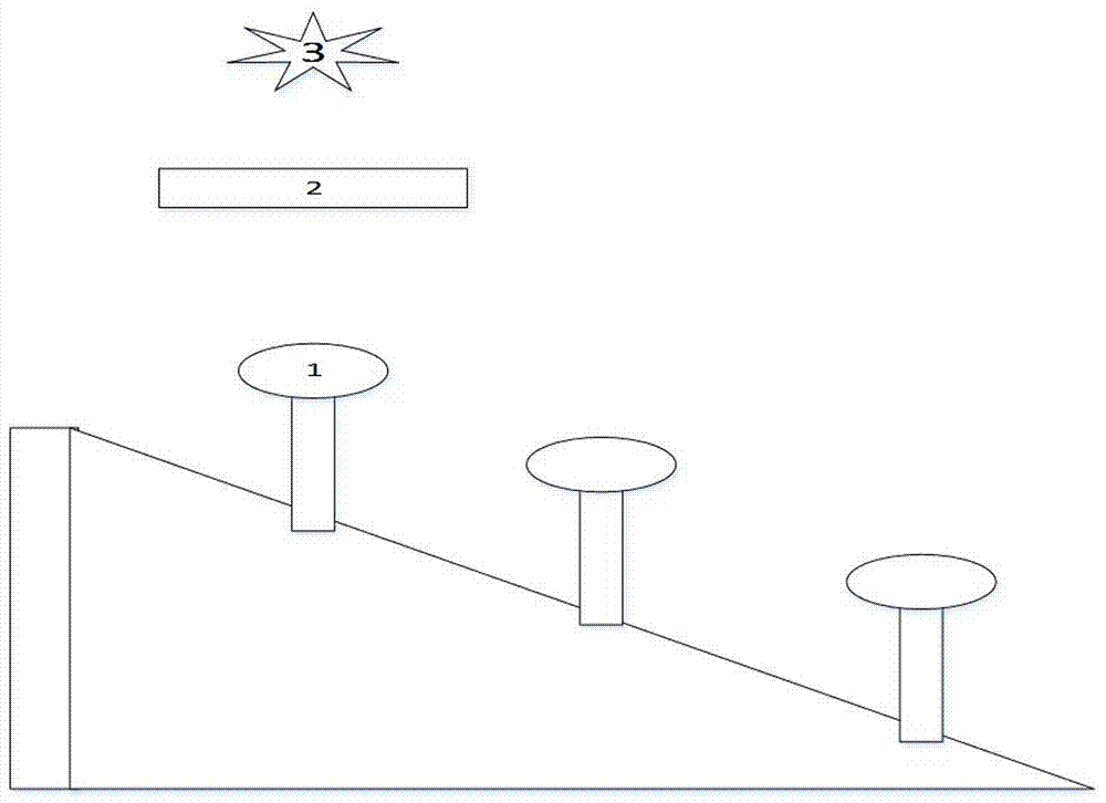
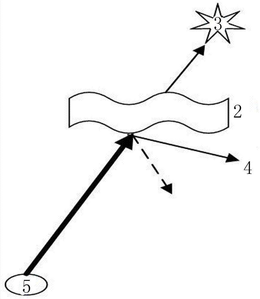
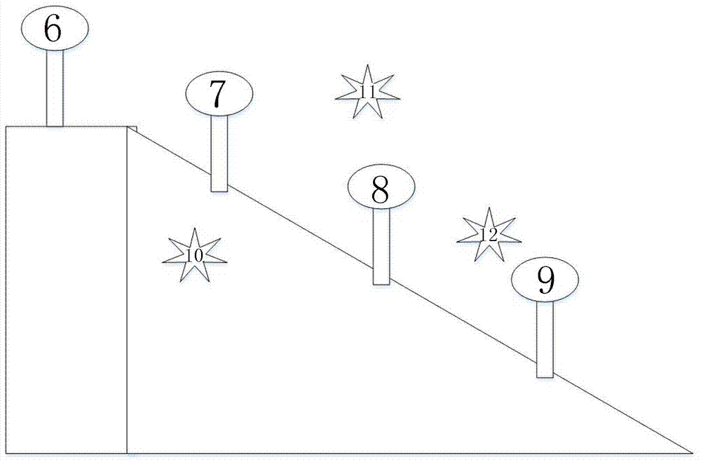
[0025] Such as image 3 , as shown in 4, a kind of landslide monitoring and early warning equipment based on pseudo-GPS, comprises landslide monitoring reference station 6, landslide monitoring station 7-9 and pseudo-GPS station 10-12, and 1 landslide monitoring reference station 6 is located at stable and texture At the uniform mountain top, 3 pseudo-GPS stations 10-12 and 3 landslide monitoring stations 7-9 are all located on the slope with landslide suspicion; and 3 pseudo-GPS stations 10-12 are not arranged in the same plane, forming a Three-dimensional space; landslide monitoring reference station 6, landslide monitoring station 7-9 and pseudo GPS station 10-12, adopt ZigBee technology to communicate between two.

[0026] Such as Figure 5 As shown, the landslide monitoring station includes a GPS information receiving module, a processor module, a ZigBee wireless communication module and a power supply module; the power supply module supplies power for the GPS informatio...


PUM


Abstract

The invention discloses a pseudo-GPS-based landslide monitoring and early warning device and an early warning method. The device includes a landslide monitoring reference station, a landslide monitoring station and pseudo-GPS stations. The landslide monitoring reference station is located at a stable and homogenous mountain top, and the pseudo-GPS stations and the landslide monitoring station areboth located on slopes suspected of landslides. The pseudo-GPS stations are not arranged in the same plane and form a three-dimensional space. Each two of the landslide monitoring reference station, the landslide monitoring station, and the pseudo-GPS stations are in communication by ZigBee technology. The device is used for landslide early warning and GPS-like satellites are used to transmit information at close range, so that the device has a real-time communication function and the communication is effective in real time. The device information transmission is in the same space, and the information transmission is almost free from external interference, so that the device has a high accuracy of information transmission.

Description

technical field [0001] The invention relates to the field of electronic equipment, and relates to a pseudo-GPS-based landslide monitoring and early warning equipment and an early warning method. Background technique [0002] Traditional landslide monitoring models such as figure 1 , figure 2 As shown, most of the current landslide monitoring systems use GPS and Beidou satellites for information transmission. Due to the long distance of signal transmission, the transmission takes a long time, making it difficult to provide effective real-time early warning; traditional GPS and Beidou satellites are used for information transmission. When the signal passes through the interference of the atmosphere, the weather is different and the interference of the atmosphere is different, which leads to the obvious instability of the accuracy of signal transmission. Therefore, the positioning accuracy of the traditional landslide monitoring and early warning system is low. [0003] In v...

Claims


Application Information

Patent Timeline
Patent Type & Authority Applications(China)
IPC IPC(8): G08B21/10G08B25/10G01S19/13
CPCG08B21/10G08B25/10G01S19/13
Inventor 张法全王海飞肖海林毛学港贾小波王国富叶金才王晶
Owner GUILIN UNIV OF ELECTRONIC TECH
Why Eureka
Try Eureka