An Offline Geocoding Unstructured Address Resolution System

An unstructured and geocoding technology, applied in structured data retrieval, geographic information database, electronic digital data processing and other directions, can solve the problem of slow interface, longitude and latitude coordinate points cannot be used uniformly, and online maps do not provide the function of associated traffic objects Wait for the problem to achieve the effect of fast speed

Active Publication Date: 2022-01-14
SHANGHAI SEARI INTELLIGENT SYST CO LTD
View PDF12 Cites 0 Cited by
  • Summary
  • Abstract
  • Description
  • Claims
  • Application Information

AI Technical Summary

Problems solved by technology

[0004] (1) The error rate is high when unstructured addresses are used for semantic recognition;
[0005] (2) The coordinates of each online map POI address library are incomplete, which makes the conversion accuracy of geocoding low;
[0006] (3) The coordinate systems of each online map are different, and the converted latitude and longitude coordinate points cannot be used uniformly;
[0007] (4) Geocode conversion can only be performed in an environment with Internet access;
[0008] (5) The interface speed of accessing remote services through the HTTP / HTTPS protocol is slow;
[0009] (6) Each online map remote service has a daily access limit, which is not suitable for large-scale geocoding;
[0010] (7) Each online map does not provide the function of linking traffic objects

Method used


Image

  • An Offline Geocoding Unstructured Address Resolution System
  • An Offline Geocoding Unstructured Address Resolution System
  • An Offline Geocoding Unstructured Address Resolution System

Examples


Embodiment Construction

[0034] In order to make the present invention more comprehensible, the embodiments of the present invention will be described in detail below in conjunction with the accompanying drawings: this embodiment is implemented under the technical solution of the present invention, and the implementation process and effect of the present invention are given. The protection scope of the present invention is not limited to the following examples.
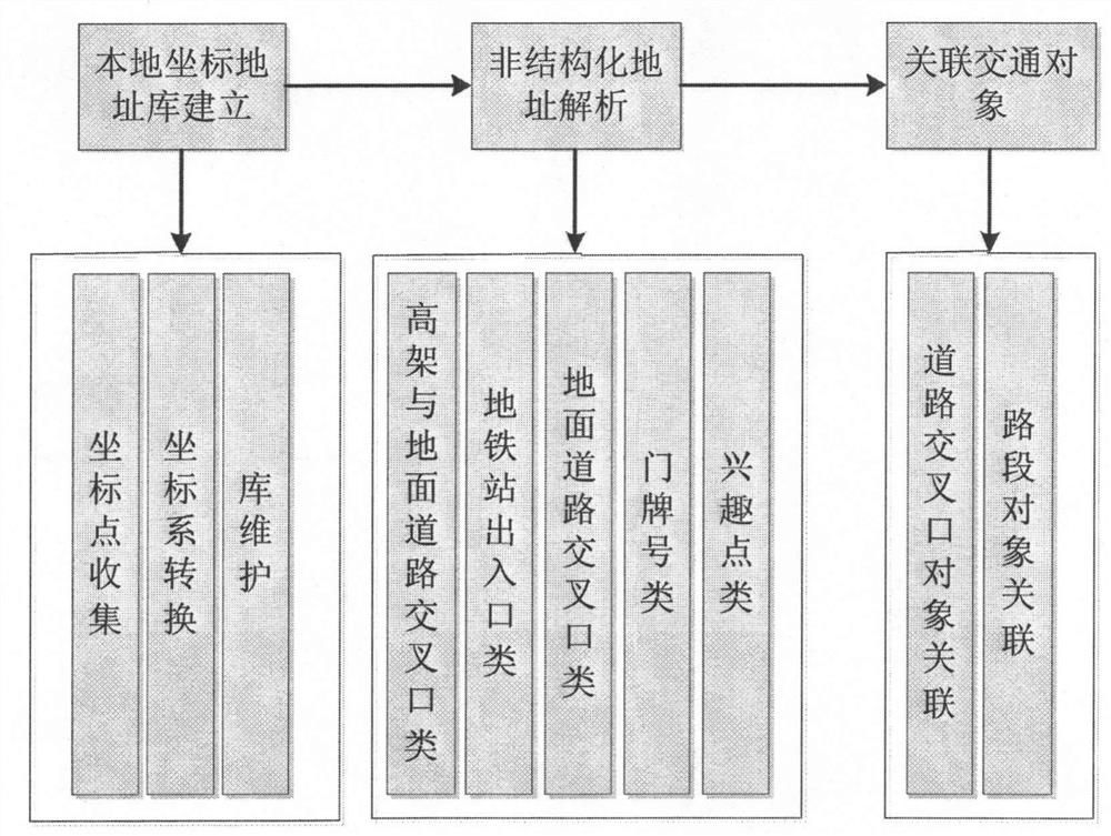
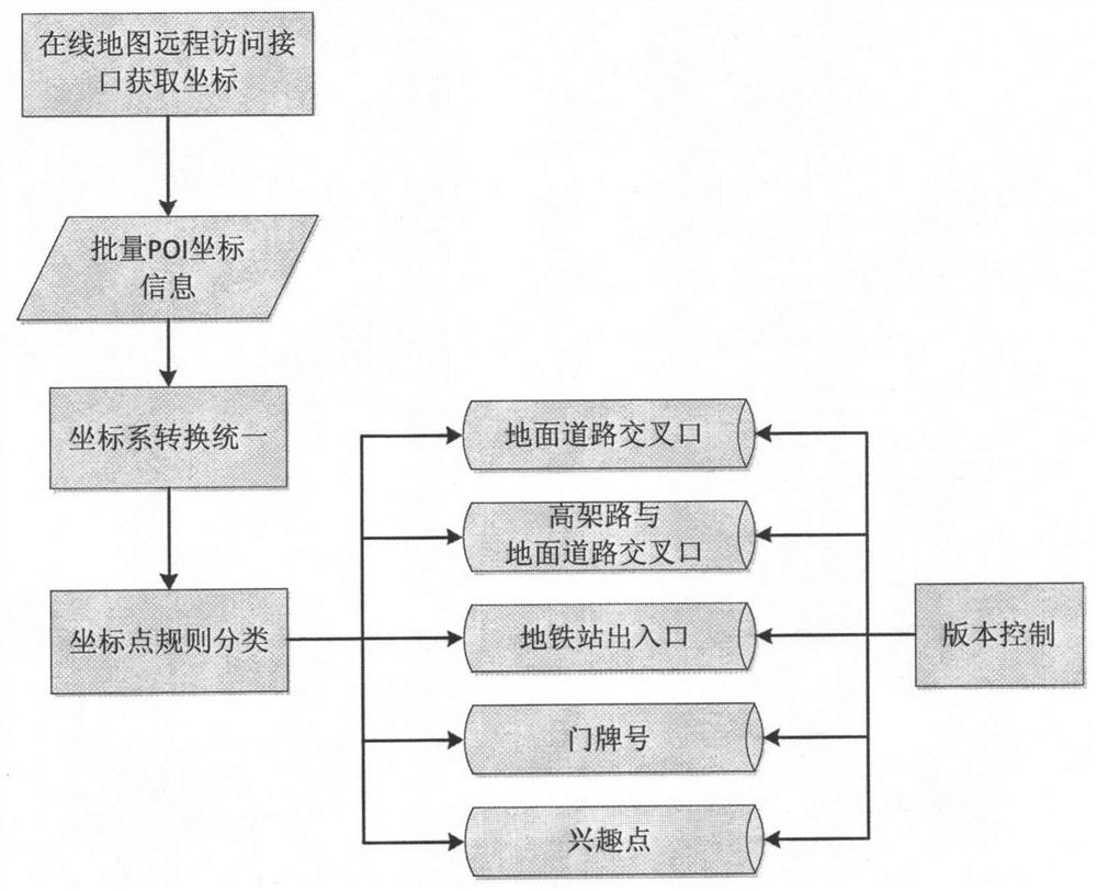
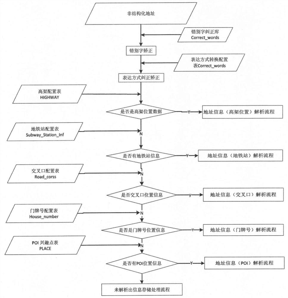
[0035] The general idea of ​​the present invention is: the local unified coordinate system address database is established, various POI position coordinate points are collected through the remote service interface of each online map, different coordinate systems are converted into unified WGS84 coordinates, entered in the local coordinate database, through The POI library of each online map complements the local library. Decompose the unstructured address one by one according to the accuracy and match the geographic coordinate points in the l...


PUM


Abstract

The invention provides an off-line geocoding unstructured address analysis system, which is characterized in that it includes: a local POI coordinate library establishment module; an unstructured address geocoding analysis module; and an associated traffic object module. The invention has the advantages that the off-line geocoding using the address coordinates of the local database does not depend on the remote interface of the Internet, the speed is fast, and it supports the geocoding address resolution of unstructured addresses, and is suitable for large batches of unstructured address resolutions. The analyzed geographic location points are associated with traffic objects, and the joint description of coordinate points and traffic objects lays the foundation for later data mining analysis.

Description

technical field [0001] The invention relates to a method of geocoding unstructured address information by using address coordinates stored in a local database, converting the longitude and latitude information corresponding to the address information, and combining the longitude and latitude information of each traffic object in the map layer to associate the address information with The system related to traffic objects is applicable to the traffic information and geographic analysis service industries, and belongs to the technical field of geocoding address resolution. Background technique [0002] Geographic location coordinate information is the basis for specific analysis and statistical mining of geospatial information. People frequently use unstructured address information in their daily life, and the derivative development of any technology application needs to be based on precise geographic location coordinate information. In order to provide accurate geographic co...

Claims


Application Information

Patent Timeline
Patent Type & Authority Patents(China)
IPC IPC(8): G06F16/29G06F16/2455G06F16/9537G06K9/62
CPCG06F16/29G06F16/3331
Inventor 陈平吴超腾沈丹凤苏贵民崔鑫王天瑞
Owner SHANGHAI SEARI INTELLIGENT SYST CO LTD
Why Eureka
Try Eureka