High-accuracy engineering three-dimensional terrain making method based on BIM cross-platform technology

A technology of three-dimensional terrain and production methods, applied in the field of BIM (Building Information Modeling), can solve the problems of low engineering three-dimensional terrain accuracy, affecting the quality of engineering design, distortion, etc., and achieve the effect of promoting application and development, improving design quality and display effect.

Active Publication Date: 2018-06-01
河南省水利勘测设计研究有限公司
View PDF5 Cites 8 Cited by
  • Summary
  • Abstract
  • Description
  • Claims
  • Application Information

AI Technical Summary

Problems solved by technology

To carry out engineering 3D design, it is first necessary to obtain high-precision engineering 3D terrain. However, due to the large investment and time-consuming of high-precision engineering terrain measurement, it is often impossible to do it in the early design stage of the project, so it can only be based on 1:10,000, 1:5 10,000, 1:200,000 and other small-scale low-precision topographic maps for design, resulting in low precision of the project's 3D topography, serious distortion, and poor engineering display effect, which seriously affects the quality of the early stage design of the project

Method used


Image

  • High-accuracy engineering three-dimensional terrain making method based on BIM cross-platform technology
  • High-accuracy engineering three-dimensional terrain making method based on BIM cross-platform technology
  • High-accuracy engineering three-dimensional terrain making method based on BIM cross-platform technology

Examples


Embodiment Construction

[0041] The embodiments of the present invention will be described in detail below in conjunction with the accompanying drawings. This embodiment is implemented on the premise of the technical solution of the present invention, and detailed implementation methods and specific operating procedures are provided, but the scope of protection of the present invention is not limited to the following Described embodiment.

[0042] The high-precision engineering three-dimensional terrain production method based on BIM cross-platform technology described in the present invention is now described in detail by taking a 1:10,000 low-precision CAD topographic map of a mountainous area with a length and width of 6.3 km as a specific example:

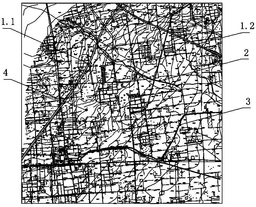
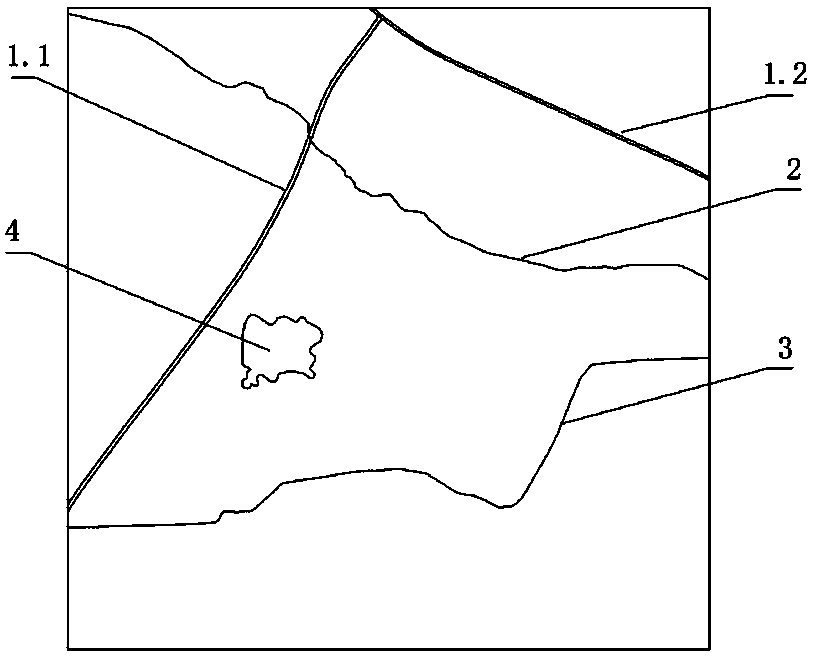
[0043] Such as figure 2As shown, the low-precision CAD topographic map requires key features including two roads 1.1 and 1.2 , a river ditch 2 , a channel 3 and a pond 4 . These ground features are only displayed as the surrounding environment of the...


PUM


Abstract

The invention discloses a high-accuracy engineering three-dimensional terrain making method based on a BIM cross-platform technology. On the basis of BIM, a GIS and a game terrain sculpting technology, through cross-platform technology fusion, a low-accuracy terrain map is adopted to generate a high-accuracy realistic engineering three-dimensional terrain. The high-accuracy engineering three-dimensional terrain making method based on the BIM cross-platform technology includes the following steps of 1, extracting contour lines, elevation points and characteristic lines; 2, generating a low-accuracy DEM; 3, sculpting a terrain and making terrain textures; 4, making a high-accuracy three-dimensional terrain grid model; 5, synthesizing the terrain model and the textures. According to the high-accuracy engineering three-dimensional terrain making method based on the BIM cross-platform technology, on the premise of strictly keeping terrain elevation basically constant, by using the low-accuracy and small-scale terrain map for generating the high-accuracy realistic engineering three-dimensional terrain, three-dimensional design requirements are met in early-stage works, the design qualityand display effects in the early-stage works are greatly improved, and application and development of BIM in the engineering field are promoted.

Description

technical field [0001] The present invention relates to the application of BIM (building information model; English abbreviation of Building Information Modeling) technology, GIS (Geographic Information System; English abbreviation of Geographic Information System) technology and game-related terrain carving technology in engineering design, especially related to the application based on A high-precision engineering 3D terrain production method based on BIM cross-platform technology. Background technique [0002] BIM is Building Information Modeling, which is not only a manifestation of engineering 3D design results, but also a design concept, method, process and specification. At present, engineering 3D collaborative design based on BIM has become the mainstream and gradually replaces traditional 2D design. To carry out engineering 3D design, it is first necessary to obtain high-precision engineering 3D terrain. However, due to the large investment and time-consuming of hi...

Claims


Application Information

Patent Timeline
Patent Type & Authority Applications(China)
IPC IPC(8): G06F17/50G06F17/30G06T17/05
CPCG06T17/05G06F16/29G06F30/13
Inventor 屈志刚朱太山贾少燕高英冯光伟陈功军张玉明王新平白勇谢冰李政鹏侯燕曲晓宁葛均建姚亮亮
Owner 河南省水利勘测设计研究有限公司
Why Eureka
Try Eureka