Shallow-sea water depth radar remote sensing method

A detection method and water depth technology, applied in the field of remote sensing detection, can solve the problem of low accuracy of shallow water depth and achieve the effect of improving detection accuracy

Active Publication Date: 2018-06-05
中科卫星应用德清研究院 +1
View PDF6 Cites 4 Cited by
  • Summary
  • Abstract
  • Description
  • Claims
  • Application Information

AI Technical Summary

Problems solved by technology

[0006] In view of this, the present invention provides a shallow sea depth radar remote sensing detection method, which solves the problem of underwater topography detection in shallow seas with large areas and ...

Method used


Image

  • Shallow-sea water depth radar remote sensing method
  • Shallow-sea water depth radar remote sensing method
  • Shallow-sea water depth radar remote sensing method

Examples


Embodiment 1

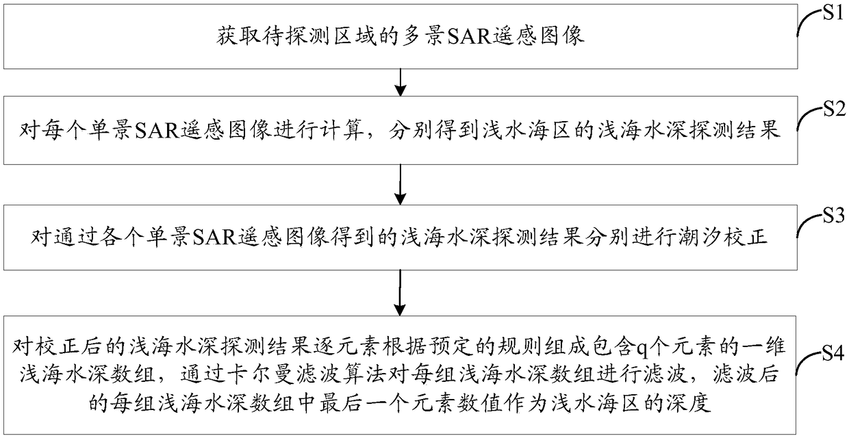
[0034] figure 1 It is a flow chart of the steps of the shallow water depth radar remote sensing detection method in Embodiment 1 of the present invention, as figure 1 As shown, the method includes the following steps S1 to S4.

[0035] Step S1: Obtain multi-view SAR remote sensing images of the area to be detected.

[0036] Among them, the multi-view SAR remote sensing image includes q single-view SAR remote sensing images, and each single-view SAR remote sensing image is an image at different imaging moments of the area to be detected, and each single-view SAR remote sensing image contains The image features transmitted to the shallow sea area, q is a natural number greater than 1.

[0037] Preferably, in order to improve the accuracy of depth detection in shallow water, after obtaining the single-view SAR remote sensing image, before performing the following step S2, the multi-view SAR remote sensing image is first screened, specifically, firstly, according to the single-v...

Embodiment 2

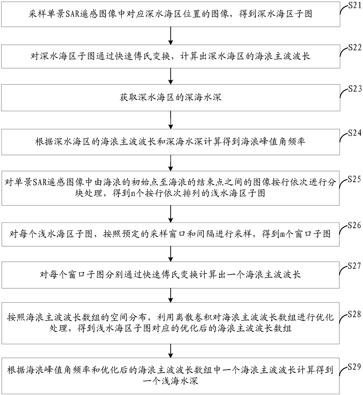
[0065]Embodiment 2 of the present invention provides a preferred shallow water depth radar remote sensing detection method on the basis of the above embodiment 1, Figure 4 It is a flow chart of the steps of the shallow water depth radar remote sensing detection method described in Embodiment 2 of the present invention, Figure 5 It is a flow chart of steps for calculating shallow sea depth based on single-view SAR remote sensing images in the shallow sea depth radar remote sensing detection method described in Embodiment 2 of the present invention, as Figure 4 and Figure 5 As shown, in this method, each single-view SAR remote sensing image is firstly calculated to obtain the shallow sea depth based on the single-view SAR remote sensing image, and then the shallow sea depth calculated by all the single-view SAR remote sensing images is fused, and finally the depth to be detected is obtained. The shallow water depth of the area.

[0066] Firstly, the method for calculating ...


PUM


Abstract

The invention discloses a shallow-sea water depth radar remote sensing method. The shallow-sea water depth radar remote sensing method comprises the following steps: acquiring a multi-view SAR remotesensing image of a to-be-detected area, wherein the multi-view SAR remote sensing image comprises q single-view SAR remote sensing images, and each single-view SAR remote sensing image contains imagecharacteristics of a sea wave transmitted from a deep sea area to a shallow sea area in the to-be-detected area; calculating each single-view SAR remote sensing image to obtain a shallow-sea water depth detection result in the shallow sea area; performing tidal correction on the shallow-sea water depth detection result obtained from each single-view SAR remote sensing image; according to a predetermined rule, element by element, forming a one-dimensional shallow-sea water depth array containing q elements based on each corrected shallow-sea water depth detection result, and according to a Kalman filter algorithm, filter each shallow-sea water depth array, wherein the numerical value of the last element in each filtered shallow-sea water depth array is used as the depth of the shallow sea area. By the shallow-sea water depth radar remote sensing method, the accuracy of shallow-sea water deep detection can be improved.

Description

technical field [0001] The invention relates to the technical field of remote sensing detection, and more specifically, to a shallow sea depth radar remote sensing detection method. Background technique [0002] Shallow sea underwater topography is one of the important marine environmental parameters, and ocean bathymetry is an important content of dynamic monitoring and management of marine environment. Traditional marine bathymetry is mainly based on shipborne acoustic detection. This method has mature technology and high detection accuracy, but the measurement period is long, the cost is high, and there are measurement blank areas in shallow seas where ships are difficult to reach. [0003] Radar remote sensing has all-weather and all-weather earth observation capabilities, and has obvious advantages in the inversion and acquisition of dynamic parameters of the marine environment. It is an indispensable means of marine environment monitoring. Using radar remote sensing i...

Claims


Application Information

Patent Timeline
IPC IPC(8): G01S13/90
CPCG01S13/90G01S13/9027
Inventor 卞小林邵芸谢酬张春燕
Owner 中科卫星应用德清研究院
Why Eureka
Try Eureka