Rotary support for three-dimensional digital geologic photogrammetry system

A photogrammetry, rotating support technology, applied in machine/support, supporting machine, camera device, etc., can solve the problems of limited rotating motion orbit, inability to guarantee, difficult photo matching and synthesis, etc., to improve work efficiency and simple operation , the effect of expanding the sampling range

Inactive Publication Date: 2018-06-26
湖北松日新材料有限公司
View PDF0 Cites 1 Cited by
  • Summary
  • Abstract
  • Description
  • Claims
  • Application Information

AI Technical Summary

Problems solved by technology

[0003] One is that the rotation track provided for the camera is limited; the other is that it is impossible to guarantee that the actual geodetic coordinates of the camera will remain unchanged during

Method used


Image

  • Rotary support for three-dimensional digital geologic photogrammetry system
  • Rotary support for three-dimensional digital geologic photogrammetry system
  • Rotary support for three-dimensional digital geologic photogrammetry system

Examples


Embodiment Construction

[0021] In order to more clearly illustrate the purpose, technical solutions and advantages of the present invention, the present invention will be further described in detail below in conjunction with the accompanying drawings and embodiments. It should be understood that the specific embodiments described here are only used to explain the present invention, not to limit the present invention. In addition, the technical features involved in the various embodiments of the present invention described below may be combined with each other as long as there is no conflict with each other.

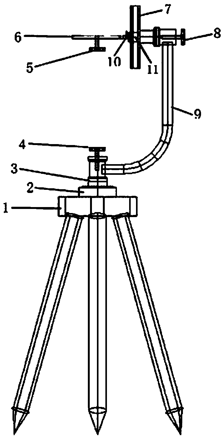
[0022] Such as figure 1 As shown, a rotating bracket of a geological three-dimensional digital photogrammetry system is used to be installed on a tripod structure for field measurement, and a fixed GPS base 2 is installed on the measurement tripod 1, and the bearing (marked in the figure) The rotating bracket of the three-dimensional digital camera is connected with the GPS base 2. The GPS base...


PUM


Abstract

The invention discloses a rotary support for a three-dimensional digital geologic photogrammetry system. The rotary support comprises a tripod (1), a horizontal rotary bent rod (9) and a vertical rotary slide groove (7), wherein a support fixing base (3) is installed on the tripod (1), and connected with the horizontal rotary bent rod (9); the horizontal rotary bent rod (9) is connected with the vertical rotary slide groove (7); and a vertical slide block (11) is arranged in the vertical rotary slide groove (7), and a camera fixing base (6) is installed on the vertical slide block (11). The rotary support disclosed by the invention is capable of conveniently adjusting the rotation angles of a camera in the horizontal direction and the vertical direction, thereby expanding the camera-shooting sampling range; and meanwhile, different pictures can be integrated into a large regional three-dimensional picture through reference points on the pictures.

Description

technical field [0001] The invention relates to a camera rotating support, in particular to a rotating support of a geological three-dimensional digital photogrammetry system. Background technique [0002] The application of digital photogrammetry technology in the field of geological engineering in the field of engineering is mainly to establish a digital model of the surface of geological bodies through photographic technology to provide data and analysis basis for the sketching, cataloging, and safety monitoring of geological features. The basic principle of this technology is to use the two-dimensional digital photos obtained on-site and the coordinate information of the on-site measurement points, and introduce the computer application technology of graphics and perspective theory to carry out three-dimensional synthesis. The coordinates of the measurement points are provided by the surveying and mapping profession. According to the design work plan, the designated geol...

Claims


Application Information

Patent Timeline
IPC IPC(8): F16M11/22F16M11/12G01C11/02
CPCF16M11/22F16M11/046F16M11/12G01C11/02
Inventor 张尔杰
Owner 湖北松日新材料有限公司
Why Eureka
Try Eureka