
Address refinement processing method and device for positioning navigation, logistics navigation system and terminal

A technology of positioning, navigation and processing methods, applied in the field of electronic maps, can solve problems such as manual filling, accurate positioning, and deviations, and achieve the effect of improving efficiency

Active Publication Date: 2020-06-02
NAVINFO
View PDF6 Cites 0 Cited by
  • Summary
  • Abstract
  • Description
  • Claims
  • Application Information

AI Technical Summary

Problems solved by technology

At present, for the logistics system, the addresses available to users are divided into four levels: province, address city, district / county, street / township, and town, among which province, address city, district / county, street / township are generally from Big data of the country's administrative divisions, but detailed addresses such as neighborhoods, building names, building numbers, unit numbers, floors, room numbers or road names, and house numbers need to be filled in manually, which is time-consuming, laborious, and inefficient
[0003] In the application scenarios of taxi or food delivery, if the location information provided by the electronic map is not precise enough, the user's location will not be accurately positioned, and the merchant will make deviations or even make mistakes when determining the user's location, resulting in a decline in user experience.
For example, in the scenario of taking a taxi, if the user wants to make an appointment to go to the airport from a certain place on a certain day, if the address of a certain place he fills in cannot be accurately located on the electronic map, the driver may fail to pick up the passenger on time
[0004] In the prior art, there is a geographic address information coding scheme, which mainly includes digitized "geographical location code" and literal "current address code", wherein "geographical location code" includes "regional absolute position code", " In the application process, the relative position code of the specific location" and "identification code" can be used for manual addressing applications, navigation map applications, logistics route planning applications, etc. It does not describe how to provide more detailed address information so that geographic address information can be more accurate in various application scenarios, and mentions the accuracy and timeliness of services provided by merchants

Method used


Image

  • Address refinement processing method and device for positioning navigation, logistics navigation system and terminal
  • Address refinement processing method and device for positioning navigation, logistics navigation system and terminal
  • Address refinement processing method and device for positioning navigation, logistics navigation system and terminal

Examples


Embodiment Construction

[0066] Certain terms are used, for example, in the description and claims to refer to particular components. Those skilled in the art should understand that hardware manufacturers may use different terms to refer to the same component. The specification and claims do not use the difference in name as a way to distinguish components, but use the difference in function of components as a criterion for distinguishing. As mentioned throughout the specification and claims, "comprising" is an open term, so it should be interpreted as "including but not limited to". "Approximately" means that within an acceptable error range, those skilled in the art can solve the technical problem within a certain error range and basically achieve the technical effect. The following descriptions in the specification are preferred implementation modes for implementing the present invention, but the descriptions are for the purpose of illustrating the general principles of the present invention, and ...


PUM


Abstract

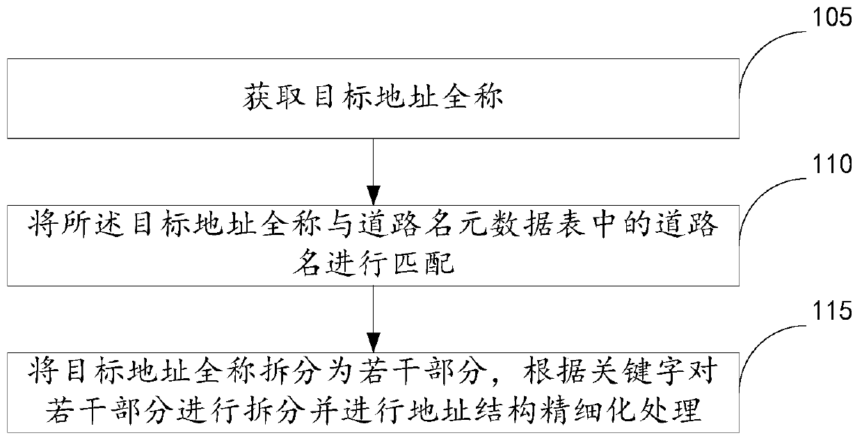
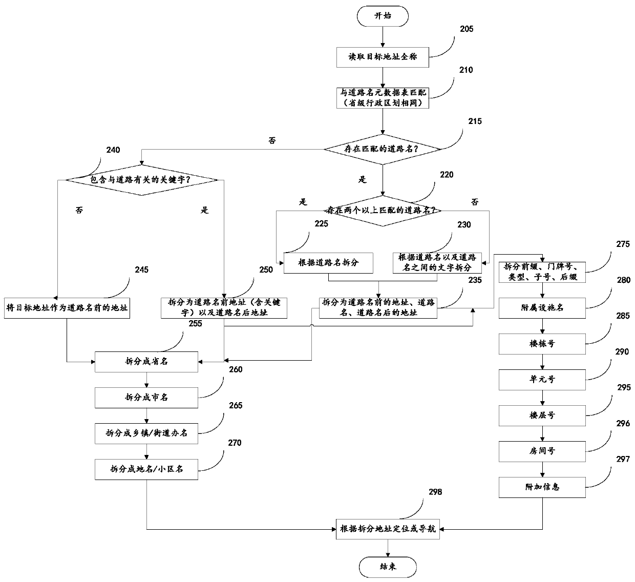
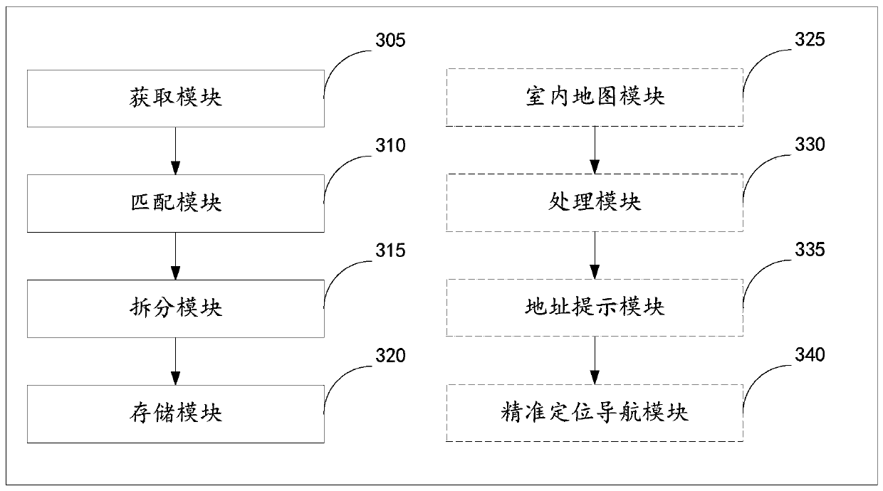
The invention discloses an address refinement processing method and device for positioning navigation, a logistics navigation system and a terminal. The method includes obtaining a full name of a target address; matching the full name of the target address with a road name in a road name metadata table; splitting the full name of the target address into a plurality of parts according to a matchingresult, using a preset keyword table to perform address structure refinement processing on the plurality of parts, and obtaining a refined target address for performing precise positioning navigationand storing the refined target address in map data. According to the method, the target address is split through an existing road name database and keywords, and the split address is utilized to improve the efficiency and accuracy of the logistics sorting service and can be applied to indoor navigation scenes, indoor facilities are subjected to layered display, which allows people to intuitivelyand quickly browse facilities on each floor, and accurate navigation of indoor maps is achieved.

Description

technical field [0001] The invention relates to the field of electronic maps, in particular to a method and device for address refinement processing of positioning navigation, a logistics navigation system and a terminal. Background technique [0002] With the development of mobile Internet technology, electronic maps have been applied in many scenarios, such as logistics, taxi, online shopping, takeaway and other application scenarios, all need the assistance of electronic maps. At present, for the logistics system, the addresses available to users are divided into four levels: province, address city, district / county, street / township, and town, among which province, address city, district / county, street / township are generally from Big data on the country's administrative divisions, but detailed addresses such as neighborhoods, building names, building numbers, unit numbers, floors, room numbers or road names, and house numbers need to be filled in manually, which is time-co...

Claims


Application Information

Patent Timeline
Patent Type & Authority Patents(China)
IPC IPC(8): G01C21/32
CPCG01C21/32
Inventor 崔玮
Owner NAVINFO
Learn More