Aerial image parallel aerial-triangulation and recursion fusion method

A technology of aerial imagery and fusion method, which is applied in the field of surveying and mapping science, can solve the problems of aerial imagery with large data volume, etc., achieve broad application prospects, eliminate the dislocation of blocks and edges, and improve efficiency and accuracy

Inactive Publication Date: 2018-07-27
北京中测智绘科技有限公司
View PDF7 Cites 4 Cited by
  • Summary
  • Abstract
  • Description
  • Claims
  • Application Information

AI Technical Summary

Problems solved by technology

[0005] The purpose of the present invention is to provide a parallel aerial triangulation and recursive fusion method of aerial images to solve the aerial triangulation problem of large data volume aerial images

Method used


Image

  • Aerial image parallel aerial-triangulation and recursion fusion method
  • Aerial image parallel aerial-triangulation and recursion fusion method
  • Aerial image parallel aerial-triangulation and recursion fusion method

Examples


Embodiment Construction

[0016] The technical solutions in the embodiments of the present invention will be clearly and completely described below in conjunction with the accompanying drawings in the embodiments of the present invention. Obviously, the described embodiments are only some of the embodiments of the present invention, not all of them. Based on the embodiments of the present invention, all other embodiments obtained by persons of ordinary skill in the art without making creative efforts belong to the protection scope of the present invention.

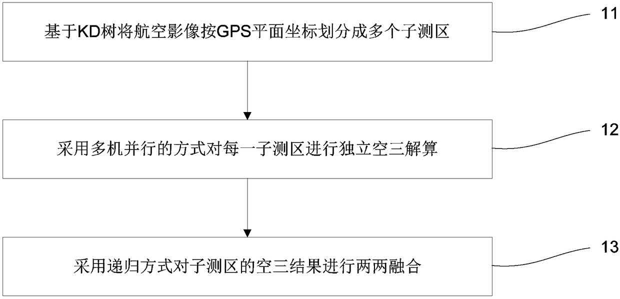
[0017] An embodiment of the present invention provides a parallel aerial three-dimensional and recursive fusion method for aerial images, such as figure 1 Said, the method mainly includes the following steps:

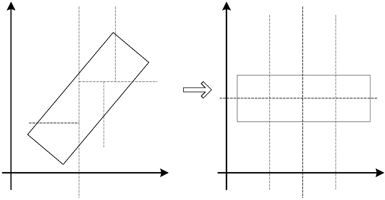
[0018] Step 1. Based on the KD tree, the aerial image is divided into multiple sub-survey areas according to the GPS plane coordinates.

[0019] In the embodiment of the present invention, the number of images contained in each sub-survey a...


PUM


Abstract

The invention discloses an aerial image parallel aerial-triangulation and recursion fusion method. The method comprises the following steps: dividing a large-scale testing zone into a plurality of testing sub-zones according to a GPS plane coordinate by utilizing a KD tree algorithm, controlling the number of images of each testing sub-zone, respectively establishing a free network by adopting theexisting SFM algorithm by virtue of a multi-machine parallel way, adjusting by using a GPS-supported light bundle method, finally gradually fusing the aerial-triangulation results of the testing sub-zones by adopting a recursion-type algorithm, and obtaining an aerial-triangulation result of the entire testing zone. The method has the advantages that the segmented SFM way is performed for the large-area testing zone, so that the problems that the massive data SFM is large in error, the speed is low and the success cannot be achieved can be solved; and by adopting the recursion fusion method,each image in the obtained aerial-triangulation result only has one exclusive group of calculation results, and the splicing staggering problem of the testing zone is solved.

Description

technical field [0001] The invention relates to the field of surveying and mapping science and technology, in particular to a method for parallel aerial triangulation and recursive fusion of aerial images. Background technique [0002] Aerial photogrammetry is an important technical means in the field of surveying and mapping production. Its principle is to take pictures of the ground area through the camera on the aircraft, and then use photogrammetric aerial triangulation (referred to as air triangulation) to perform geometric processing on the aerial images to obtain the image quality. Internal and external orientation elements and air three encryption points. [0003] Traditional aerial photography generally uses a vertically downward camera to shoot, and the routes are relatively regular (for example, the routes are parallel or perpendicular to each other), and the traditional aeronautical method can be used for aeronautical calculations more conveniently. With the ris...

Claims


Application Information

Patent Timeline
Patent Type & Authority Applications(China)
IPC IPC(8): G01C11/34
CPCG01C11/34
Inventor 熊小东朱俊锋曾晓茹
Owner 北京中测智绘科技有限公司
Why Eureka
Try Eureka