
Geological disaster monitoring system and geological disaster monitoring method
A monitoring system and technology for geological disasters, applied in the field of satellite monitoring, can solve the problems of increasing the number of technicians and travel costs for installation and maintenance, increasing equipment costs and labor costs, and low operating efficiency, and achieve convenient geological disaster monitoring services, The effect of reducing equipment cost and labor cost
- Summary
- Abstract
- Description
- Claims
- Application Information
AI Technical Summary
Problems solved by technology
Method used
Image

Examples
Embodiment 1
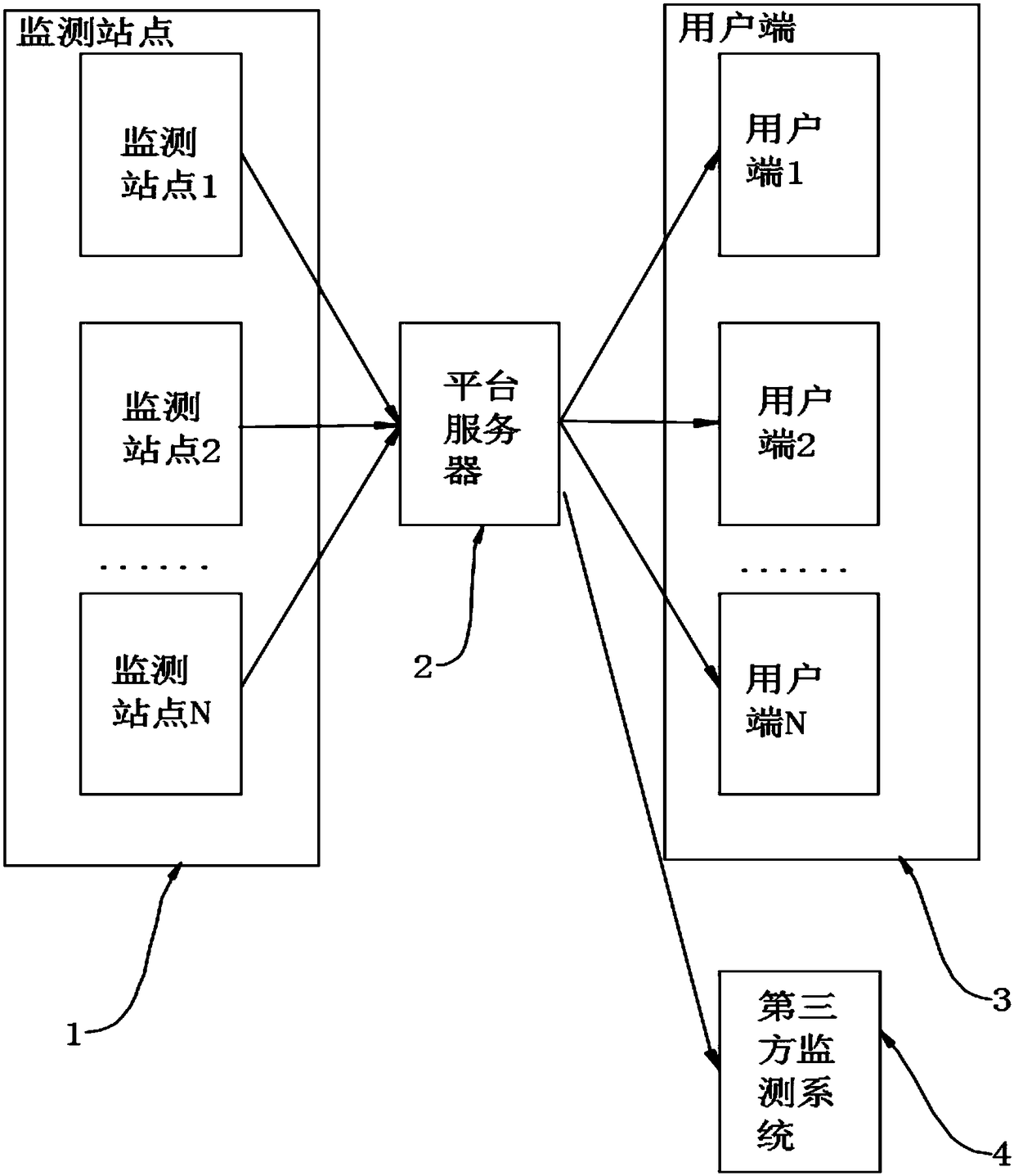
[0037] like figure 1 The shown a kind of geological hazard monitoring system includes monitoring site 1, platform server 2 and client terminal 3; the monitoring site 1 includes a number of GNSS monitoring equipment, and the number of GNSS monitoring equipment distributed in the monitoring site 1 of each project will monitor data Upload to the platform server 2; the platform server 2 is operated by the technical service provider, and the platform server 2 performs centralized calculation, filtering and statistics on the monitoring data uploaded by each monitoring site and generates early warning information; each client 3 receives The calculation data and early warning information corresponding to the corresponding monitoring site 1 uploaded by the platform server 2 .
[0038] By setting up the platform server 2 to perform unified management and calculation of the monitoring data uploaded by each monitoring site 1, and send the calculation data and early warning information to ...
Embodiment 2
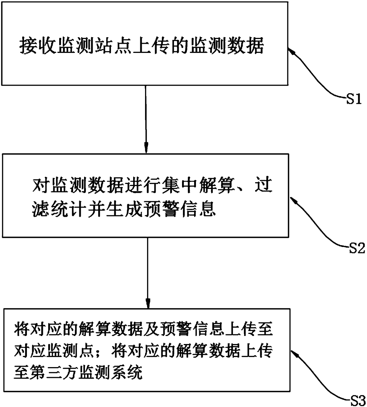
[0042] like figure 2 A kind of geological disaster monitoring method shown, comprises the following steps:
[0043] S1: Receive the monitoring data uploaded by the monitoring site;
[0044] S2: Perform centralized calculation of monitoring data, filter statistics and generate early warning information;
[0045] S3: Upload the corresponding calculation data and early warning information to the monitoring site.
[0046] Through the unified management and calculation of geological disaster monitoring projects in various places, the work efficiency of technical service providers can be improved and their labor maintenance costs can be reduced. At the same time, equipment costs and labor costs of users can be reduced, and more effective and efficient Economical and more convenient geological disaster monitoring service.
[0047] Specifically, the uploading step also includes uploading the corresponding calculation data to a third-party monitoring system. By uploading the calcula...
Embodiment 3
[0049] like figure 2 As shown, Embodiment 3 discloses an electronic device, including a memory, a processor, and a computer program stored in the memory and operable on the processor. When the processor executes the program, the following steps are implemented:
[0050] S1: Receive the monitoring data uploaded by the monitoring site;
[0051] S2: Perform centralized calculation of monitoring data, filter statistics and generate early warning information;
[0052] S3: Upload the corresponding calculation data and early warning information to the monitoring site.
[0053] It should be noted that one or more processors and memories can be used, and the program is stored in the memory and configured to be executed by the processor. When the processor executes the program, the geological disaster monitoring method of Embodiment 2 is realized. The electronic device may be a series of electronic devices such as a mobile phone, a computer, and a tablet computer.
[0054] Specifica...
PUM
 Abstract
Description
Claims
Application Information