Hyperspectral-remote-sensing-image classification technology combining spectral, spatial and hierarchical information

A technology of hierarchical structure and image classification, applied in the field of image processing, can solve the problems of large band correlation, insufficient extraction of spatial information, and high dimension of hyperspectral images, so as to reduce the misclassification of categories, improve the classification accuracy of ground objects, and improve the accuracy of ground object classification. The effect of accurate classification accuracy

Active Publication Date: 2018-08-21
CHINA UNIV OF GEOSCIENCES (WUHAN)
View PDF8 Cites 10 Cited by
  • Summary
  • Abstract
  • Description
  • Claims
  • Application Information

AI Technical Summary

Problems solved by technology

However, hyperspectral images have high dimensionality, high band correlation, noise and mixed pixels, and limited ground truth data references, which bring great challenges to the analysis and processing of hyperspectral remote sensing information.
The single-kernel image classification method based on spectral features only determines the category of pixels based on the spectral features of ground objects, and does not use the spatial information of the image, so the classification accuracy obtained by this type of method is difficult to further improve
The composite nuclear image classification method based on spectral and spatial information is bas

Method used


Image

  • Hyperspectral-remote-sensing-image classification technology combining spectral, spatial and hierarchical information
  • Hyperspectral-remote-sensing-image classification technology combining spectral, spatial and hierarchical information
  • Hyperspectral-remote-sensing-image classification technology combining spectral, spatial and hierarchical information

Examples


Embodiment Construction

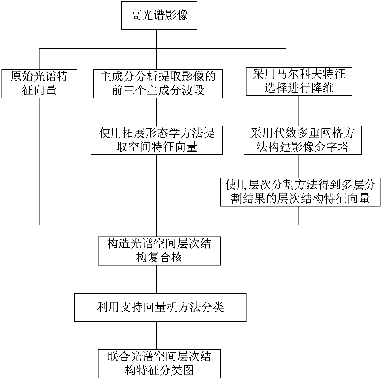
[0048] In order to make the purpose, technical solution and advantages of the present invention clearer, the embodiments of the present invention will be further described below in conjunction with the accompanying drawings.

[0049] Please refer to figure 1 , an embodiment of the present invention provides a hyperspectral image classification method that provides joint spectral, spatial and hierarchical information, comprising the following steps:

[0050] S1. Input the hyperspectral image to be classified obtained by the optical sensor; and input the ground survey data sample set corresponding to the hyperspectral image to be classified;

[0051] S2. According to the coordinate positions of all samples in the ground survey data sample set, extract the pixels corresponding to the coordinate positions in the original hyperspectral image to form a reference data sample set;

[0052] S3. The reference data sample set of the obtained hyperspectral image includes multiple informati...


PUM


Abstract

The invention discloses a hyperspectral-remote-sensing-image classification technology combining spectral, spatial and hierarchical information. The technology includes: inputting a to-be-classified hyperspectral image, and extracting a reference data sample set; selecting a training sample set of supervised classification; using principal component analysis to extract top-three principal component wavebands of the image, and using an extension morphology method to extract spatial feature vectors; using Markov feature selection to carry out dimension reducing on the original image, using the algebraic multi-grid method to construct the image pyramid, and using a hierarchical segmentation method to obtain multi-layer segmentation results; combining original spectral feature vectors, the spatial feature vectors and hierarchical feature vectors to construct multiple kernel matrices; using a support vector machine method to calculate kernel matrix differences to obtain final class attribute labels; and outputting a final image classification graph. The invention provides an effective classification method, which can fully extract and mine image information, and can effectively improveclassification accuracy of the hyperspectral image.

Description

technical field [0001] The invention relates to the technical field of image processing, in particular to a hyperspectral image classification method combining spectral, spatial and hierarchical information. Background technique [0002] Compared with multispectral remote sensing images, hyperspectral remote sensing images have richer information, which can accurately reflect the attribute differences between different types of ground objects, realize accurate extraction and identification of ground objects, and provide more accurate hyperspectral remote sensing image analysis. Lay a good foundation with industry applications. However, hyperspectral images have high dimensionality, high band correlation, noise and mixed pixels, and limited ground truth data references, which bring great challenges to the analysis and processing of hyperspectral remote sensing information. The single-kernel image classification method based on spectral features only determines the classifica...

Claims


Application Information

Patent Timeline
IPC IPC(8): G06K9/00G06K9/62
CPCG06V20/13G06V20/194G06F18/2135G06F18/2411G06F18/214
Inventor 王毅段和祥
Owner CHINA UNIV OF GEOSCIENCES (WUHAN)
Why Eureka
Try Eureka