
Road edge detection method based on laser radar and camera

A technology of laser radar and detection method, which is applied in the field of intelligent transportation, to achieve the effect of overcoming the huge point cloud data, improving detection accuracy and real-time detection

Active Publication Date: 2018-09-11
CHONGQING UNIV OF POSTS & TELECOMM
View PDF6 Cites 59 Cited by
  • Summary
  • Abstract
  • Description
  • Claims
  • Application Information

AI Technical Summary

Problems solved by technology

[0006] In view of this, the object of the present invention is to provide a roadside detection method based on laser radar and camera, which can fully utilize the advantages of multi-sensor fusion, improve the detection accuracy, stability and robustness of the roadside, and can detect the roadside in real time. , to overcome many problems of single sensor in environment perception application

Method used


Image

  • Road edge detection method based on laser radar and camera
  • Road edge detection method based on laser radar and camera
  • Road edge detection method based on laser radar and camera

Examples


Embodiment Construction

[0040] Hereinafter, the preferred embodiments of the present invention will be described in detail with reference to the accompanying drawings.

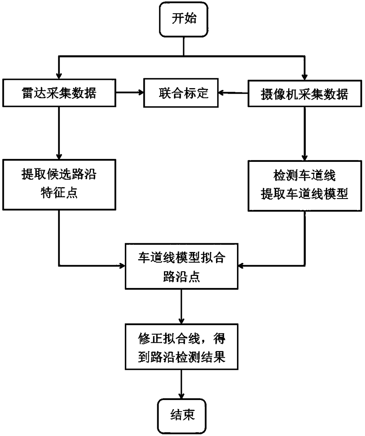
[0041] In this embodiment, the IBEO-LUX 2010 four-line lidar is used as the radar point cloud data acquisition sensor, and the low-light camera is used as the image data acquisition sensor, and an algorithm is written in the VS2013 environment to implement a roadside detection method in an unmanned vehicle. The specific implementation is as figure 1 As shown, including the following steps:

[0042] Step 1. Use lidar to obtain roadside point cloud data, and use a camera to obtain road image data; the radar point cloud data includes a plurality of scan points containing polar coordinate information; the image data includes images of lane lines and roadsides;

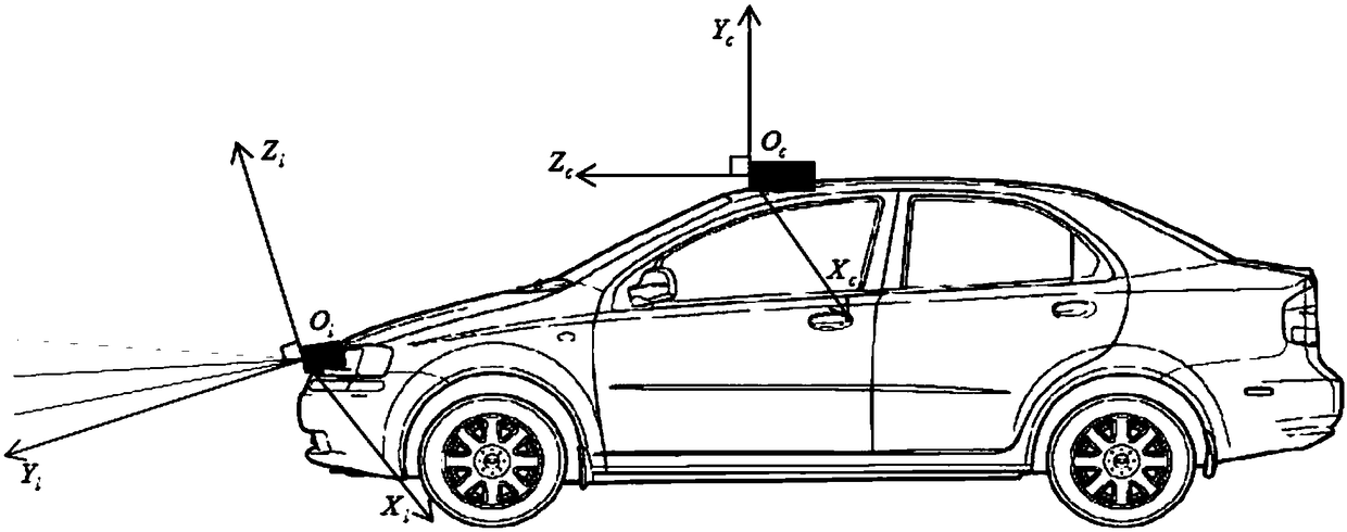
[0043] Step 2: Preprocess the radar data and camera data separately, and perform joint calibration;

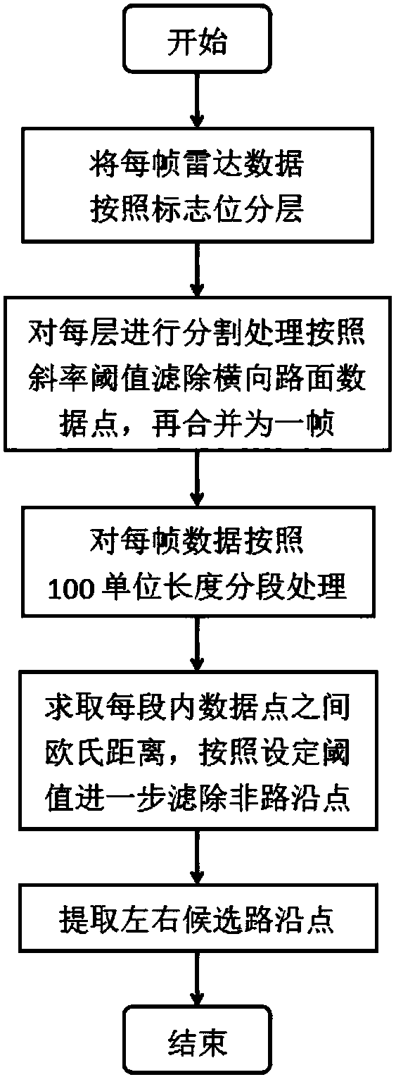
[0044] Step 3: Process each frame of radar point cloud data. For each layer of scan ...


PUM


Abstract

The invention relates to a road edge detection method based on a laser radar and a camera, and belongs to the field of intelligent traffic. The method comprises the steps: acquiring road edge point cloud data through the laser radar; acquiring road image data through the camera; separately preprocessing the radar data and the camera data, and performing joint calibration; processing each frame ofradar point cloud data, and extracting candidate road edge feature points for each scanning line according to the linear features of a road edge through a method based on a distance; processing each frame of image data, and detecting a lane line in the image through a mature method, and extracting a lane line model; carrying out the fitting of the extracted candidate feature points through the lane line model; determining the distances between the candidate road edge points and a fitting line, correcting the fitting line through the road edge points, and obtaining a road edge detection result.The method can make the most of the advantages of the laser radar and the camera to precisely and stably detect the road edge.

Description

Technical field [0001] The invention belongs to the field of intelligent transportation and relates to a roadside detection method based on a laser radar and a camera. Background technique [0002] With the development of society, economy and technology, there are more and more vehicles on traffic roads, and the road environment is becoming more and more complicated. The subsequent traffic accidents also occur frequently. In order to reduce the occurrence of such situations, intelligent transportation In intelligent transportation, intelligent vehicles are a key part of intelligent transportation. The emergence of intelligent vehicles helps drivers to drive and reduces the frequency of traffic accidents. [0003] Driverless vehicles are an important part of the intelligent transportation system. Driverless vehicles in the driving urban environment need to have a good perception of the surrounding complex traffic environment, including the perception of the maximum driving boundary ...

Claims


Application Information

Patent Timeline
IPC IPC(8): G01S17/93G01S17/02
CPCG01S17/86G01S17/931
Inventor 蒋建春王旭华朱浩
Owner CHONGQING UNIV OF POSTS & TELECOMM
Learn More