Urban group boundary identification method and device, equipment and storage medium

A technology of boundary recognition and urban agglomeration, applied in the computer field, can solve the problems of high subjectivity, lack of theoretical basis, and complicated methods of urban agglomeration boundaries

Active Publication Date: 2018-09-11
LANZHOU JIAOTONG UNIV
View PDF4 Cites 9 Cited by
  • Summary
  • Abstract
  • Description
  • Claims
  • Application Information

AI Technical Summary

Problems solved by technology

[0005] The present invention provides a method, device, equipment and storage medium for identifying urban agglomeration boundaries to solve the problems of greater subjectivity, complicated methods, or lack of theoretical basis for identifying urban agglomeration boundaries in countries and regions. Flexible, accurate and time-sensitive identification of urban agglomeration boundaries

Method used


Image

  • Urban group boundary identification method and device, equipment and storage medium
  • Urban group boundary identification method and device, equipment and storage medium
  • Urban group boundary identification method and device, equipment and storage medium

Examples


Embodiment 1

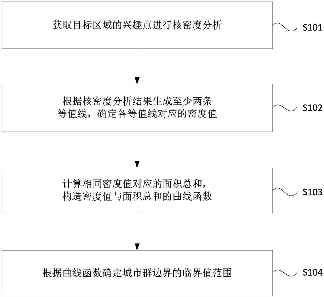
[0040] figure 1 It is a flow chart of an urban agglomeration boundary identification method provided in Embodiment 1 of the present invention. This embodiment is applicable to the situation of identifying urban agglomeration boundaries, and the method can be executed by the urban agglomeration boundary identification device or equipment provided in the embodiment of the present invention , the device can be implemented in the form of hardware and / or software, specifically including the following steps:

[0041] S101. Obtain interest points in the target area to perform kernel density analysis.

[0042] Among them, the target area is the area of ​​actual human activities to be studied. Since the urban agglomeration is uncertain at this time, the obtained points of interest are also the points of interest in the target area of ​​actual human activities. The point of interest (Point of Interest, POI) refers to spatial features with geographical identification, and is the basic d...

Embodiment 2

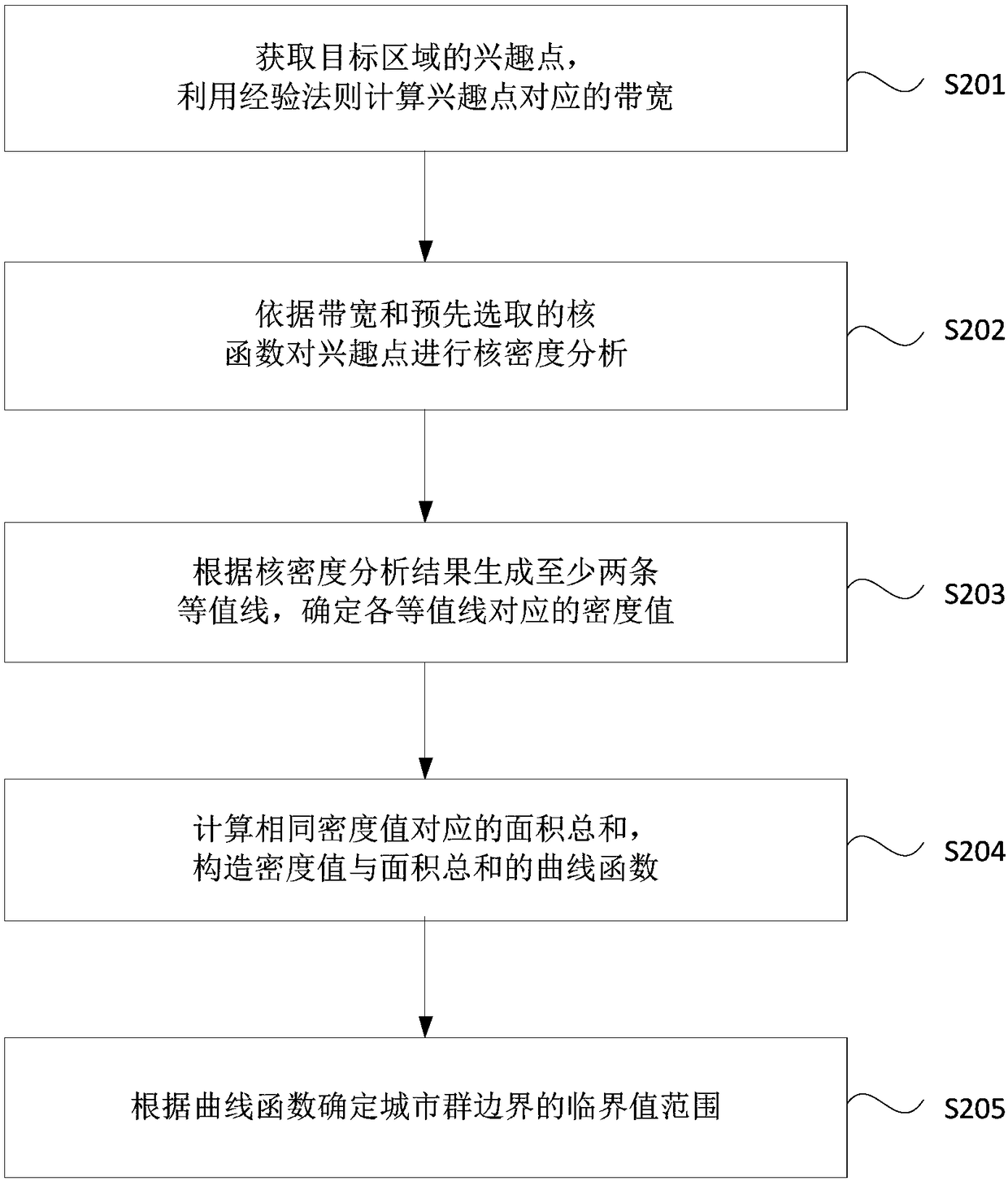
[0064] figure 2 It is a flow chart of a method for identifying an urban agglomeration boundary provided by Embodiment 2 of the present invention. In this embodiment, on the basis of the above-mentioned embodiments, S101 in the above-mentioned embodiments is further explained to obtain the interest points of the target area for kernel density analysis. The method includes:

[0065] S201. Acquire interest points in the target area, and calculate bandwidth corresponding to the interest points by using empirical rules.

[0066] When analyzing interest points, a smaller bandwidth can reflect local changes, but may cause peaks with large errors in the analysis results; a larger bandwidth reflects changes in the overall scale, but may miss or smooth out some Important details and features conceal the real spatial structure of urban agglomeration density. Therefore, it is very important to determine a reasonable bandwidth. It is necessary to determine the reasonable bandwidth of th...

Embodiment 3

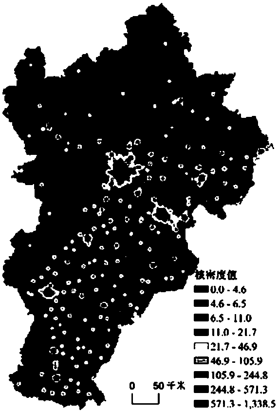
[0085] On the basis of the above-mentioned embodiments, this embodiment provides a preferred embodiment, taking China's three major urban agglomerations (Beijing-Tianjin-Hebei urban agglomeration, Yangtze River Delta urban agglomeration and Pearl River Delta urban agglomeration) as examples, combined with Figure 3- FIG. 7 is a further schematic illustration of a method for identifying the boundary of an urban agglomeration proposed by the above-mentioned embodiments of the present application.

[0086] The first step is to use the crawler software to obtain the points of interest in the target area of ​​the three major urban agglomerations in the electronic map provided by the data supplier, load the obtained points of interest with the shapefile data of the type of point of interest through ArcGIS software, set the coordinate system and carry out Gauss Kruger projection, complete data preprocessing of points of interest.

[0087] The second step is to perform kernel density a...


PUM


Abstract

The embodiment of the invention discloses an urban group boundary identification method and device, equipment and a storage medium. The method includes the steps of acquiring interesting points of a target area for nuclear density analysis; generating at least two contour lines according to results of the nuclear density analysis, and determining a density value corresponding to each contour line;calculating the sum of areas corresponding to the same density value, and constructing a curve function of the sum of the density values and the areas; determining a critical value range of boundaries of an urban group according to the curve function. According to the embodiment, the practical problems that the boundaries of national and regional identification urban groups are high in subjectivity and methods are complicated or lack theoretical bases are solved, and the boundary range of the urban group can be flexibly and accurately identified in real time according to distribution conditions of the spatial interesting points of actual human activities.

Description

technical field [0001] Embodiments of the present invention relate to the field of computer technology, and in particular, to a method, device, equipment, and storage medium for identifying an urban agglomeration boundary. Background technique [0002] Urban agglomeration is the theme space form of China's new urbanization development, and also the most dynamic and potential growth pole in China's future economic development. Therefore, rationally defining the scale and boundaries of urban agglomerations is an important prerequisite for understanding and studying urban agglomerations, and it is also the key to the country's implementation of the spatial governance system and the study of future urban agglomerations. [0003] At present, in the field of urban agglomeration boundary identification, the commonly used methods are index method and model method. Among them, the index method refers to the use of statistical yearbooks, surveys and other data to select a series of m...

Claims


Application Information

Patent Timeline
Patent Type & Authority Applications(China)
IPC IPC(8): G06F17/50G06F17/30
CPCG06F30/20
Inventor 周亮赵琪杨帆孙东琪
Owner LANZHOU JIAOTONG UNIV
Why Eureka
Try Eureka