Bus line optimizing method based on taxi GPS data and mobile phone signaling data

A technology of GPS data and mobile phone signaling, applied in data processing applications, computer components, forecasting, etc., can solve problems such as unreasonable bus line settings, low bus line operation efficiency, and inability to meet demand well, and achieve bus operation High efficiency, saving manpower and material resources, strong representative effect

Active Publication Date: 2018-09-21
HARBIN INST OF TECH
View PDF4 Cites 30 Cited by
  • Summary
  • Abstract
  • Description
  • Claims
  • Application Information

AI Technical Summary

Problems solved by technology

[0009] The purpose of the present invention is to solve the problem that the existing bus lines are unreasonably set up, cannot meet the needs well, and do not conform to the actual situation, resulting in low operating efficiency of the bus lines, and propose a bus system based on taxi GPS and mobile phone signaling data. Line Optimization Method

Method used


Image

  • Bus line optimizing method based on taxi GPS data and mobile phone signaling data
  • Bus line optimizing method based on taxi GPS data and mobile phone signaling data
  • Bus line optimizing method based on taxi GPS data and mobile phone signaling data

Examples


specific Embodiment approach 1

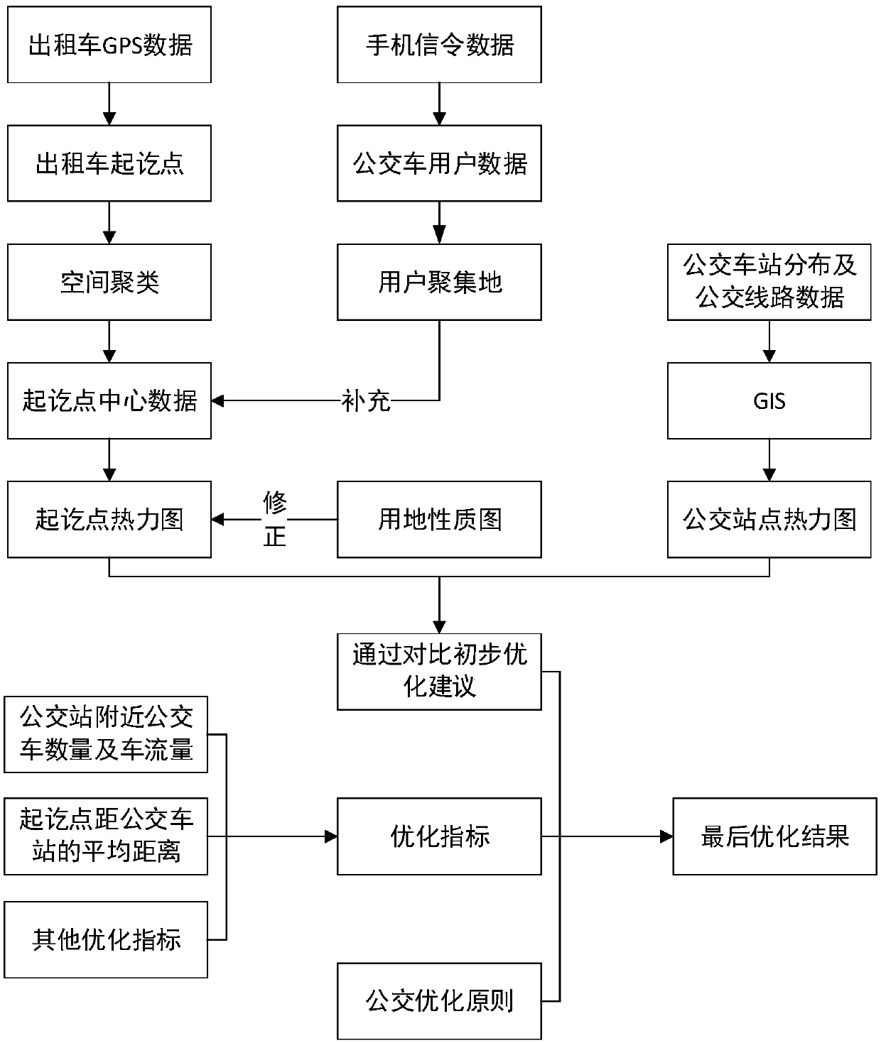
[0033] Specific implementation mode one: combine figure 1 Describe the present embodiment, a kind of bus line optimization method based on taxi GPS and mobile phone signaling data of the present embodiment concrete process is:

[0034] The method is a bus line optimization method based on vehicle GPS data and mobile phone GPS data. On the one hand, the existing mobile phone signaling data is obtained, and at the same time, the start and end points of taxi travel are integrated and clustered to obtain the distribution map of travel demand points. On the other hand, the GPS data of other vehicles or the traffic flow information of the road are obtained to facilitate the evaluation of the smoothness of bus travel. In addition, it is necessary to obtain the route and station layout information of the current bus operation.

[0035] Line optimization is performed based on the above information. Match and fit the thermal distribution map of travel demand points generated by integ...

specific Embodiment approach 2

[0057] Specific implementation mode two: the difference between this implementation mode and specific implementation mode one is: the identification of origin and destination in the step two one; the specific process is:

[0058] Identify according to the status information and instantaneous vehicle speed in the GPS data, first identify the instantaneous speed as 0 o'clock, and then identify whether the vehicle status in the GPS data is in the passenger-carrying state when the same vehicle speed is 0; if the status value is 0, then it is Empty driving state, 1 is the passenger loading state, changing from 1 to 0 is the unloading state, this point is the destination point, and the state value changes from 0 to 1 is the passenger loading state, this point is the starting point, and the starting and ending point of the trip will be Identify and serve as the basis for visualization.

[0059] Other steps and parameters are the same as those in Embodiment 1.

specific Embodiment approach 3

[0060] Specific embodiment three: the difference between this embodiment and specific embodiment one or two is that in the step two or three, the starting and ending points are clustered using DBSCAN or K-Means clustering algorithm to obtain the clustering result, according to the clustering result Get the heat map of origin and destination distribution; the specific process is:

[0061] Commonly used clustering algorithms are DBSCAN, K-Means and other spatial clustering algorithms, which can be used in matlab, pathon, SPSS and R languages. Generally, the clustering can be realized by calling the clustering program directly. The specific steps are as follows. In this case, the K-Means algorithm is used as an example to implement it using matlab.

[0062] The steps of the K-Means algorithm are as follows:

[0063] 1) Randomly select K initial centroids

[0064] 2) Calculate the distances from all samples to the K centroids respectively

[0065] 3) If the sample is closest t...


PUM


Abstract

The invention relates to a bus line optimizing method based on taxi GPS data and mobile phone signaling data, and aims to solve the problem of low operation efficiency of a bus line because the existing bus line is unreasonable in setting, cannot meet needs very well and does not conform to the actual situation. The bus line optimizing method comprises the following specific processes: 1, acquiring the taxi GPS data, acquiring the mobile phone signaling data, acquiring a land use map and acquiring bus stop data; 2, processing the data acquired in the step 1; 3, calculating bus line optimizingindexes according to the step 2; 31, calculating the distances from an origin point and a destination point to the nearest bus stop; 32, determining the number of bus lines included in the bus stop and the traffic flow; 33, calculating the average running speed of a road vehicle; 4, setting optimizing measures according to the optimizing indexes. The bus line optimizing method is applied to the field of public transportation planning.

Description

technical field [0001] The invention relates to a bus line optimization method based on taxi GPS and mobile phone signaling data, and belongs to the field of public transport planning. Background technique [0002] At present, the conventional bus network in various cities has been very developed, but with the increase of car ownership, the emergence of urban traffic congestion has a great impact on the operation efficiency of the bus network. In order to improve the operation efficiency of the bus, scholars proposed There are many optimization methods. [0003] Since the 1980s, my country began to study the optimization of urban conventional bus route network. Yang Zhaosheng assigned the bus OD to the travel route, and obtained the solution with the least passenger workload. Professor Wang Wei's method of laying out the bus network one by one with the goal of maximizing direct passenger flow. [0004] At this stage, scholars have established many optimization algorithms,...

Claims


Application Information

Patent Timeline
Patent Type & Authority Applications(China)
IPC IPC(8): G06Q10/04G06Q50/30G06K9/62
CPCG06Q10/047G06Q50/30G06F18/23213
Inventor 左文泽胡晓伟安实张瀚麟张锋
Owner HARBIN INST OF TECH
Why Eureka
Try Eureka