Mosaic method for large-scale ground-distance satellite-borne SAR images

An image mosaic, large-scale technology, applied in image enhancement, image analysis, graphic image conversion, etc., can solve the problems of laborious, time-consuming, and difficult to eliminate color difference in the mosaic process, and achieve the effect of protecting texture details and reducing demand.

Active Publication Date: 2022-02-15
HEFEI UNIV OF TECH
View PDF3 Cites 0 Cited by
  • Summary
  • Abstract
  • Description
  • Claims
  • Application Information

AI Technical Summary

Problems solved by technology

These methods usually need to register overlapping image data using visually positioned homonymous points or visual features extracted by some algorithm, and the entire mosaic process is laborious and time-consuming; It can only realize the gradual transition of overlapping areas in one direction, and it is difficult to eliminate the problem of chromatic aberration caused by overlapping areas in multiple directions; in addition, some methods require higher memory capacity of the computer

Method used


Image

  • Mosaic method for large-scale ground-distance satellite-borne SAR images
  • Mosaic method for large-scale ground-distance satellite-borne SAR images
  • Mosaic method for large-scale ground-distance satellite-borne SAR images

Examples


Embodiment Construction

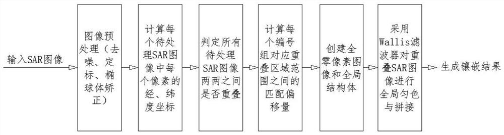
[0082] The embodiments of the present invention are described in detail below. This embodiment is implemented on the premise of the technical solution of the present invention, and detailed implementation methods and specific operating procedures are provided, but the protection scope of the present invention is not limited to the following implementation example.

[0083] The large-scale ground-distance spaceborne SAR image mosaic method includes the following steps:

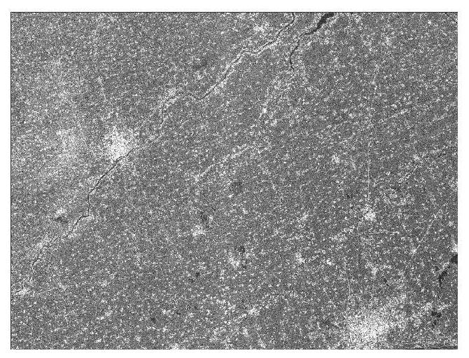
[0084] (1) Image preprocessing: In order to ensure the quality of the mosaic results, it is first necessary to preprocess the SAR images of the spaceborne ground-range wide mode; the three SAR images selected in this step are all from the Sentinel-1 satellite launched by the European Space Agency. SAR images taken in China, such as image 3 , 4 , 5 show three original SAR images:

[0085] The longitude of the image ranges from 73° east longitude to 135° east longitude, and the latitude ranges from 3° north l...


PUM


Abstract

The invention provides a large-scale ground-distance satellite-borne SAR image mosaic method, which relates to the field of satellite SAR (Synthetic Aperture Radar) image mosaic. The original image is firstly subjected to necessary preprocessing, and then the preprocessed image is extracted with geographic location information to The location information is used as prior knowledge to correct the cross-correlation of the image to obtain the mosaic error information, and use the mosaic error information to compensate the image mosaic error; after the mosaic error compensation, the Wallis filter is used to search for the updated SAR image. The method is used for uniform color processing, and the mosaiced image is finally generated; the present invention provides an optional solution for the determination of the matching offset by adapting the cross-correlation method according to different terrains or the binary matching statistics method based on the zero-crossing point; providing A search and update strategy, which guarantees the effect of uniform color processing in multiple overlapping areas and directions, and can well protect the texture details in the image.

Description

technical field [0001] The invention relates to the field of satellite SAR (Synthetic Aperture Radar) image mosaic, in particular to a large-scale ground-distance spaceborne SAR image mosaic method. Background technique [0002] Spaceborne synthetic aperture radar (SAR) has become an important tool in the field of surveying and mapping and earth science research because of its large area and all-weather and day-night imaging capabilities. Mosaicing of multiple SAR images from the same and adjacent imaging tracks is particularly useful for monitoring and analyzing the spatial and temporal variation of global processes. Spaceborne SAR mosaic products can be widely used in land use, land cover change, mapping, coastline, desertification, wetland and glacier monitoring and other fields. The key to the mosaic of ground-to-spaceborne SAR is to eliminate the geometric structure dislocation and radiation difference between the mosaic images, and it is not limited by the large-capac...

Claims


Application Information

Patent Timeline
Patent Type & Authority Patents(China)
IPC IPC(8): G06T3/40G06T5/00G06T5/50G06T7/32
CPCG06T3/4038G06T5/002G06T5/50G06T7/32G06T2207/20221G06T2207/10044G06T2207/20024
Inventor 郎文辉余不凡石聪聪赵子航
Owner HEFEI UNIV OF TECH
Why Eureka
Try Eureka