UAV-assisted WSN, as well as method for designing node scheduling, route planning and power distribution of same
A wireless sensor network and path planning technology, which is applied in the field of wireless communication technology and the Internet of Things, and can solve the problems of difficult solution process and low transmission power.
- Summary
- Abstract
- Description
- Claims
- Application Information
AI Technical Summary
Problems solved by technology
Method used
Image
Examples
Embodiment Construction
[0067] The system model of the method of the present invention is as figure 1 Shown. Combine below figure 2 The algorithm flow chart shown in the present invention specifically illustrates a non-UAV-assisted wireless sensor network based on the minimization of transmit power and its node scheduling and path planning power allocation, including the following steps:
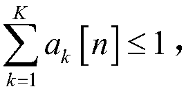
[0068] 1). Establish a three-dimensional space rectangular coordinate system (x, y, z), and the z-axis coordinates represent the height and position information of the space. K single-antenna ground terminal nodes are randomly distributed at fixed positions in the xy plane, and the position coordinates of the kth ground terminal node are (x k ,y k ,0) T , And the position coordinates of all terminal nodes form a set w k =(x k ,y k ,0) T . The UAV base station node flies in a three-dimensional space according to a certain path, and has a fixed flying height H. The single flight time of the UAV base station is T, and...
PUM
 Abstract
Description
Claims
Application Information
 - R&D
- Intellectual Property
- Life Sciences
- Materials
- Tech Scout
- Unparalleled Data Quality
- Higher Quality Content
- 60% Fewer Hallucinations
Browse by: Latest US Patents, China's latest patents, Technical Efficacy Thesaurus, Application Domain, Technology Topic, Popular Technical Reports.
© 2025 PatSnap. All rights reserved.Legal|Privacy policy|Modern Slavery Act Transparency Statement|Sitemap|About US| Contact US: help@patsnap.com


