Supercharge Your Innovation With Domain-Expert AI Agents!

Geographic information data decryption method

A geographic information data and decryption technology, which is applied in the field of remote sensing image surveying and mapping, can solve the problems that the information security situation cannot be ignored, and achieve the effect of improving the decryption accuracy

Inactive Publication Date: 2018-10-09
STATE GRID SHAANXI ELECTRIC POWER RES INST +2
View PDF6 Cites 7 Cited by
  • Summary
  • Abstract
  • Description
  • Claims
  • Application Information

AI Technical Summary

Problems solved by technology

[0004] With the rapid development of information technology, the situation of information security cannot be ignored. New technologies represented by smart terminals, Web2.0, Internet of Things and cloud computing, on the one hand, bring convenience to life and work. The ubiquity of these technologies also brings more security risks

Method used


Image

  • Geographic information data decryption method
  • Geographic information data decryption method
  • Geographic information data decryption method

Examples


Embodiment Construction

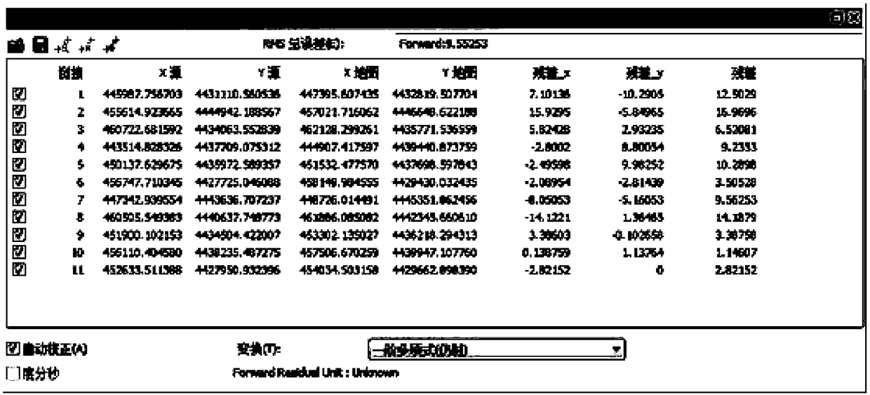
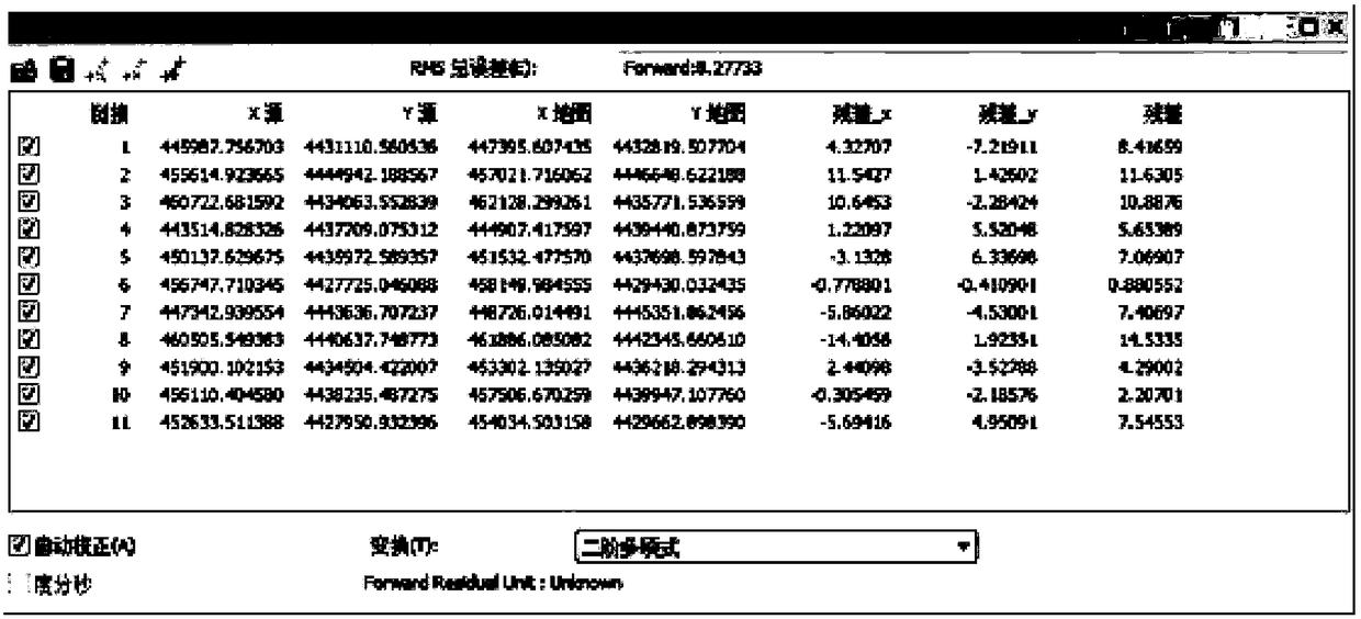
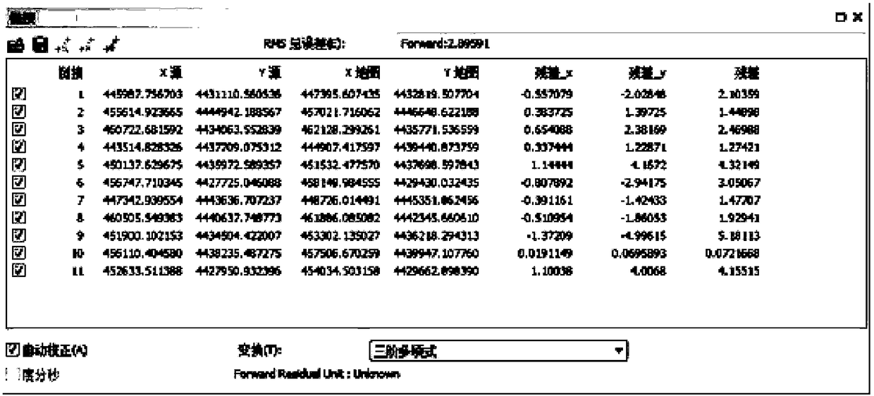
[0048] In order to have a further understanding of the technical solution and beneficial effects of the present invention, the technical solution of the present invention and its beneficial effects will be described in detail below in conjunction with the accompanying drawings.

[0049] 1. Decryption of benchmark remote sensing images

[0050] The declassification of the reference remote sensing image is carried out through coordinate translation transformation, such as figure 1 As shown, the corresponding coordinate axes of the coordinate system XOY and the coordinate system X'O'Y' are parallel to each other and have the same positive direction. The coordinate system X'O'Y' is obtained by the parallel movement of the coordinate system XOY. Let the coordinates of point P in the coordinate system XOY be (x, y), the coordinates in X'O'Y' be (x', y'), and (a, b) be the coordinates of O' in the coordinate system XOY Coordinates, so: x=x'+a, y=y'+a, which is the coordinate relati...


PUM


Abstract

The invention relates to a geographic information data decryption method, which comprises the following steps of: obtaining a reference remote sensing image of a target area; acquiring a plurality ofremote sensing sub-images of the target area; acquiring vector data of the target area; carrying out data decryption processing on the reference remote sensing image through coordinate translation transformation so as to realize the position decryption of the reference remote sensing image; using the control points on the plurality of remote sensing sub-images and the same name control points on the reference remote sensing image to align the plurality of remote sensing sub-images to complete the data decryption of each remote sensing sub-image; carrying out space transformation on the vectordata by using the same point control points on the decrypted remote sensing sub-images and the vector data, so as to complete the spatial position decryption of the vector data. According the invention, the reference remote sensing image is decrypted, the remote sensing sub-images are decrypted and the vector data is decrypted, the decryption precision is improved, and the decrypted image splicingis also realized.

Description

technical field [0001] The invention relates to the technical field of remote sensing image surveying and mapping, in particular to a method for decrypting geographic information data. Background technique [0002] At present, there are some problems in the environmental protection work of the State Grid Corporation of China, which to a certain extent restrict the rapid advancement of the feasibility study, environmental impact assessment, approval, and completion acceptance of the power transmission and transformation project, and have problems in the environmental protection and water conservation acceptance of the project after completion. Due to the lack of relevant data on the distribution of environmentally sensitive areas, in the site selection and construction stages of power transmission and transformation projects, some projects have insufficient measures and management support measures to avoid environmentally sensitive areas; the environmental impact of power tran...

Claims


Application Information

Patent Timeline
IPC IPC(8): G06F21/60G06F21/62G06T7/33G06T3/00
CPCG06F21/602G06F21/6209G06T7/337G06T2207/10032G06T3/147G06T3/14
Inventor 吴健白晓春耿明昕吕平海赵亚林鱼小兵郭季璞
Owner STATE GRID SHAANXI ELECTRIC POWER RES INST
Features
  • R&D
  • Intellectual Property
  • Life Sciences
  • Materials
  • Tech Scout
  • Unparalleled Data Quality
  • Higher Quality Content
  • 60% Fewer Hallucinations
Learn More