Confidential topographic map transmission method, confidential topographic map transmission system and use method of confidential topographic map transmission system
A transmission method and topographic map technology, applied in transmission systems, digital transmission systems, and key distribution, can solve problems such as file loss, inability to meet the requirements of intelligent pipeline construction, and adding fixed constants
- Summary
- Abstract
- Description
- Claims
- Application Information
AI Technical Summary
Problems solved by technology
Method used
Image
Examples
Embodiment 1
[0079] Embodiment 1, a confidential topographic map transmission method, comprising:
[0080] Step 1, the coordinate data of the collection points formed by the coordinates of the 4 map root control points or the corner points of the picture frame or the corner points of the feature in the confidential topographic map data of the pipeline construction site surveying and mapping, and the surveying and mapping control points in the same coordinate system as the confidential topographic map The result table is stored in the sending security machine, respectively recorded as the first data and the second data, and the four collection points are respectively marked as No. 1 collection point to No. 4 collection point;
[0081] Step 2, in the sending security machine, the surveyed and mapped confidential topographic map is arbitrarily translated by a certain distance and arbitrarily rotated by a certain angle to form the translated topographic map data, which is recorded as the fourth...
Embodiment 2
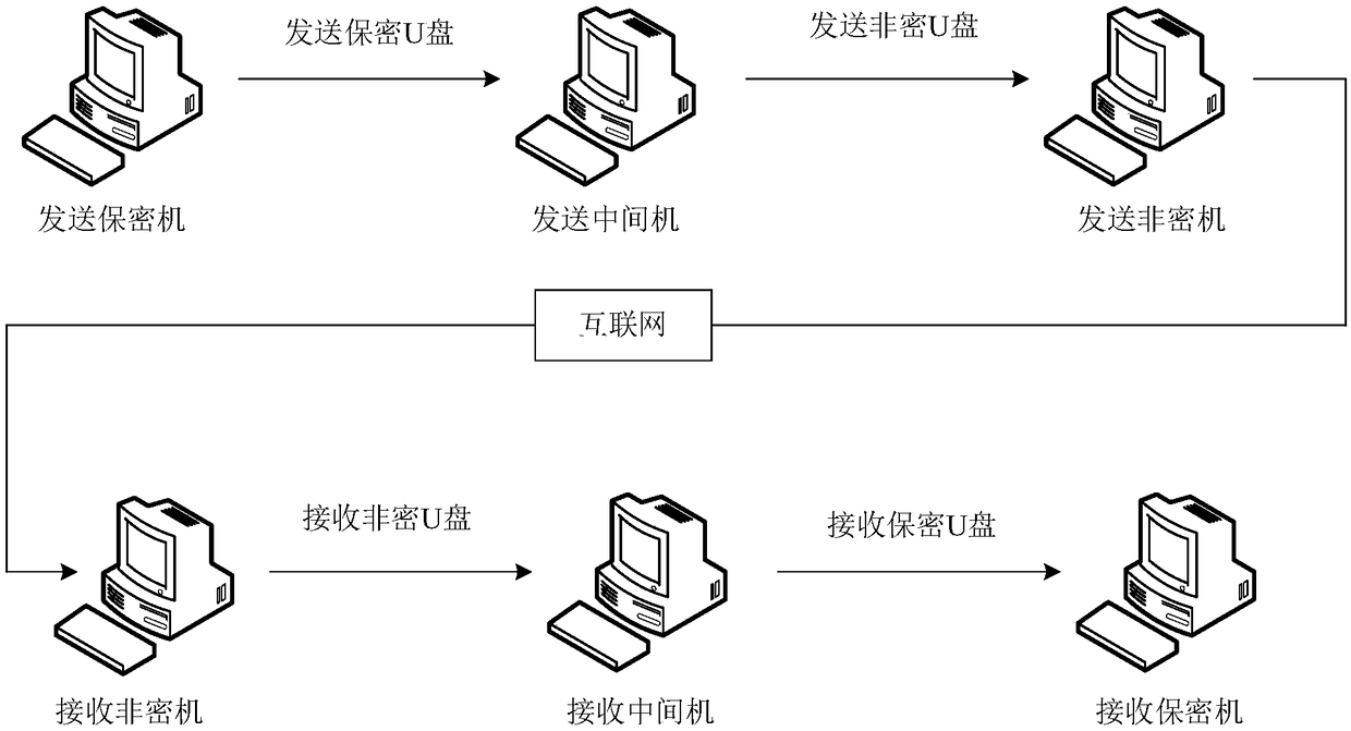
[0120] Example 2, such as figure 1 As shown, a confidential topographic map transmission system includes:
[0121] Sending security machine, which is used to store the coordinate data of the collection points formed by the coordinates of the 4 map root control points or the corner points of the picture frame or the corner points of the feature in the confidential topographic map data of on-site surveying and mapping, and the surveying and mapping in the same coordinate system as the confidential topographic map The result table of control points and the confidential topographic map of surveying and mapping are arbitrarily translated by a certain distance and rotated by a certain angle to form the translated topographic map data, which are respectively recorded as the first data, the second data and the fourth data, and the first data and the second data The data is calculated as non-confidential data with a relative relationship, which is recorded as the third data, and the th...
Embodiment 3
[0133] Embodiment 3, a method of using a confidential topographic map transmission system, comprising:
[0134] Step S1, compiling the control point file, which is the second data;
[0135] Step S2, bringing the control point file to the construction site;
[0136] Step S3, taking the control point file to other office locations that need to receive confidential topographic maps;
[0137] Step S4, collect the coordinates of 4 collection points in the confidential topographic map at the construction site, and compile the collection point file, which is the first data;
[0138] Step S5, storing the sum of the second data and the first data in the sending security machine;
[0139] Step S6, calculating the relational data file in the sending security machine, which is the third data;
[0140] Step S7, in the sending security machine, the confidential topographic map is arbitrarily translated by a certain distance and rotated by a certain angle to form the translated topographi...
PUM
 Abstract
Description
Claims
Application Information
 - R&D
- Intellectual Property
- Life Sciences
- Materials
- Tech Scout
- Unparalleled Data Quality
- Higher Quality Content
- 60% Fewer Hallucinations
Browse by: Latest US Patents, China's latest patents, Technical Efficacy Thesaurus, Application Domain, Technology Topic, Popular Technical Reports.
© 2025 PatSnap. All rights reserved.Legal|Privacy policy|Modern Slavery Act Transparency Statement|Sitemap|About US| Contact US: help@patsnap.com

