Tank truck lateral overturning early warning system based on GIS

An early warning system and liquid tanker technology, applied in the field of traffic safety, can solve the problems of driver's psychological impact, insufficient consideration of changes, accident occurrence, etc., to avoid personnel and economic losses, high reliability, and enhance the effect of universal applicability

An early warning system and liquid tanker technology, applied in the field of traffic safety, can solve the problems of driver's psychological impact, insufficient consideration of changes, accident occurrence, etc., to avoid personnel and economic losses, high reliability, and enhance the effect of universal applicability

CN108657175AActive Publication Date: 2018-10-16HEFEI UNIV OF TECH

Image

  • Tank truck lateral overturning early warning system based on GIS
  • Tank truck lateral overturning early warning system based on GIS
  • Tank truck lateral overturning early warning system based on GIS

Examples


Embodiment Construction

[0050] The present invention will be further described below in conjunction with the accompanying drawings and embodiments.

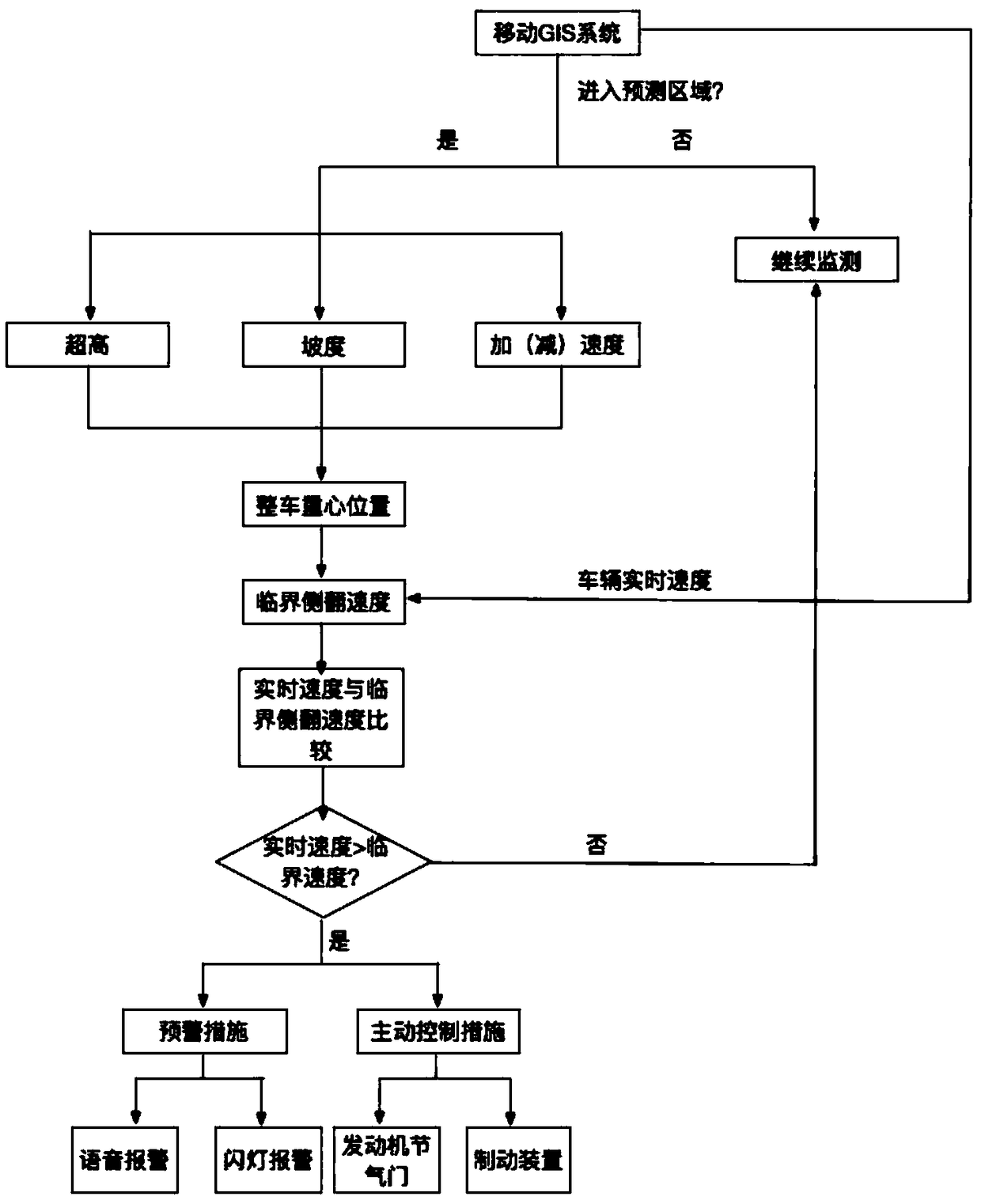
[0051] Such as figure 1 As shown in (flow chart), the liquid tank truck rollover warning and control device based on geographic information system (GIS) includes a GIS system module 1, a rollover critical speed judgment module 2, an early warning module 3, an active control module 4, and a vehicle information module 5 . The vehicle information module 5 includes a liquid level sensor 6 in the tank, and a liquid weight sensor 7 in the tank links to each other with the vehicle information module 5. Wherein the rollover critical speed judgment module 2 is connected with the GIS system module 1, the early warning module 3 is connected with the rollover critical speed judgment module 2, and the active control module 4 is connected with the rollover critical speed judgment module 2.

[0052] The GIS system is placed inside the tank truck and consists of two...


PUM


Abstract

The invention discloses a tank truck lateral overturning early warning system based on a GIS. The system comprises a mobile GIS module, a vehicle information module, a lateral overturning state judgment module, an early warning module and an active speed control module. In the system, the mobile GIS module obtains vehicle position information and obtains information of a bend and a road in the heading direction through a geographic information system; the vehicle information module stores vehicle parameter information and obtains in-tank liquid information in real time; the lateral overturningstate judgment module combines the information of the two above modules to establish a calculation model of the lateral overturning critical speed of a tank truck when the tank truck travels on the bend, compares the current traveling speed of the vehicle with the minimum lateral overturning critical speed and judges whether the vehicle can be overturned or not according to a comparison result; the early warning module warns a driver to control the vehicle speed in the modes of voice and the like when the vehicle is in lateral overturning danger; and the active speed control module reduces the vehicle speed through control of an engine throttle valve and a brake device under an emergency. The system guarantees the safety of the driver and the vehicle.

Description

technical field [0001] The invention relates to the field of traffic safety, in particular to a GIS system-based rollover warning system for tank trucks. Background technique [0002] As the country vigorously develops digital highway construction, GIS-based highway 3D GIS technology has been first implemented in many highways across the country. The current 3D GIS technology for roads can generate road ground models and create digital roads; its database can manage various information related to ground objects conveniently and quickly, and can query and retrieve according to various given conditions to provide more information. A large number of roadbed and pavement, facilities along the road, bridge intercommunication, traffic control point weather station, toll station control point and other basic road right of way attribute data provide more direct and effective technical support for the visualization of road maintenance management. [0003] As the main way of long-dis...

Claims


Application Information

Patent Timeline
16 Oct 2018
Publication
CN108657175A
IPC
B60W30/04; B60W40/105; B60W50/14; B60W10/06; B60W10/184
CPC
B60W10/06; B60W10/184; B60W30/04; B60W40/105; B60W50/14; B60W2050/143; B60W2300/12; B60W2520/10
Inventors
张卫华; 魏田宇