Stony desertification determining method based on radar backscattering coefficient time series

A technology of backscatter coefficient and time series, applied in the direction of using re-radiation, radio wave measurement system, radio wave reflection/re-radiation, etc., can solve the problems of unfavorable object area judgment, radar image only has single-band information, etc. To achieve the effect of improving the accuracy

Inactive Publication Date: 2018-11-06
GUIZHOU NORMAL UNIVERSITY
View PDF5 Cites 0 Cited by
  • Summary
  • Abstract
  • Description
  • Claims
  • Application Information

AI Technical Summary

Problems solved by technology

[0003] The technical problem to be solved by the present invention is to provide a method for judging rocky desertification based on the time series of radar backscatter coefficients, so as to solve the problem that traditional optical remote sensing images in the prior art are easily affected by multiple factors such as time and weather. Only with single-band information, both methods are not conducive to judging whether the target area belongs to the type of rocky desertification

Method used


Image

  • Stony desertification determining method based on radar backscattering coefficient time series
  • Stony desertification determining method based on radar backscattering coefficient time series
  • Stony desertification determining method based on radar backscattering coefficient time series

Examples


Embodiment 1

[0029] A method for judging rocky desertification based on the time series of radar backscatter coefficients, comprising the following steps:

[0030] Step 1: Select the radar data of the object within one year, at least one radar data per month, and the polarization mode of the radar data is consistent, so as to ensure the accuracy of the rocky desertification information extraction results in a certain area;

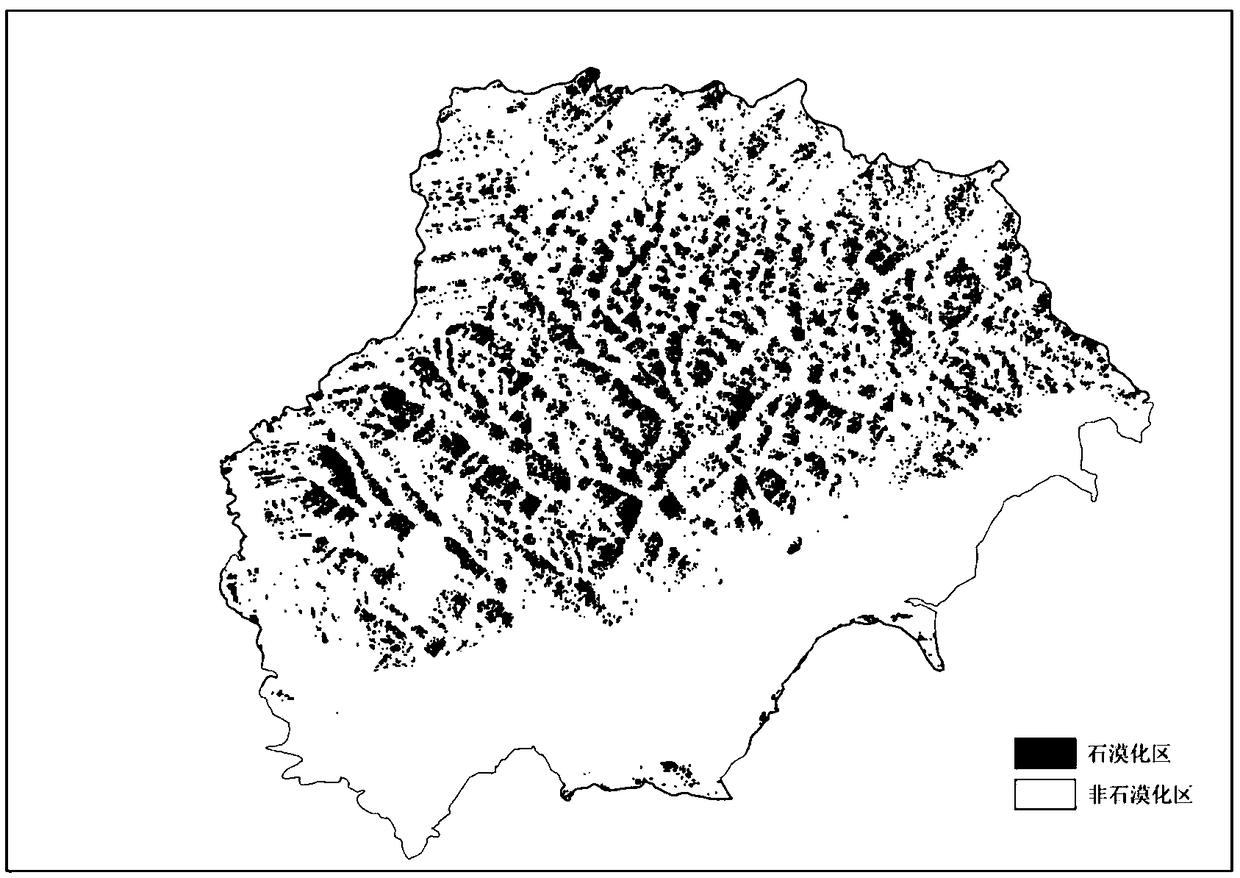
[0031] Select the area within the Qixingguan District of Bijie City, Guizhou Province with a longitude and latitude span of 104°2′00″ to 104°49′26″E, 26°27′58″ to 26°50′08″N (hereinafter referred to as the target area) as The place where the invention plan is implemented. The radar data selects C-band SAR radar data, and the data acquisition time is January 9, February 5, March 3, April 16, May 20, June 21, and July 17, 2016. On Sunday, August 19, September 21, October 23, November 18, and December 19, the data polarization mode is VV.

[0032] Step 2: In order to qu...


PUM


Abstract

The invention discloses a stony desertification determining method based on a radar backscattering coefficient time series. The method comprises firstly performing multi-temporal radar data selectionon a region with to-be-extracted rocky desertification information; then performing radiometric calibration, terrain radiation correction and speckle noise filtering on the radar data; constructing atime series based on a backscattering coefficient by using the processed radar data; and finally, determining the rocky desertification category of the target region by a DTW algorithm. The method hashigh rock desertification determining precision and solves defects that optical remote sensing is liable to be affected by cloudy and rainy weather and a single-temporal radar may cause the lack of information due to speckle noise.

Description

technical field [0001] The invention belongs to the field of rocky desertification control, in particular to a rocky desertification judging method based on the time series of radar backscatter coefficients. Background technique [0002] Rocky desertification areas are often cloudy and rainy, and although traditional optical remote sensing images have rich spectral information, they are easily affected by multiple factors such as time and weather, which creates considerable difficulties in obtaining data in rocky desertification areas . Radar images have all-weather and all-weather imaging characteristics that are not constrained by weather conditions. The image texture information is rich, and the outline of the ground objects is clear, but it only has single-band information. Both methods are not conducive to the judgment of whether the target area belongs to the type of rocky desertification . Therefore, using multi-temporal radar images to extract rocky desertification...

Claims


Application Information

Patent Timeline
Patent Type & Authority Applications(China)
IPC IPC(8): G01S13/88G01S13/89G01S7/40G01S7/41
CPCG01S7/40G01S7/41G01S13/88G01S13/89
Inventor 熊康宁陈希兰安军陈丽莎
Owner GUIZHOU NORMAL UNIVERSITY
Why Eureka
Try Eureka