Method and system for change detection based on multi-temporal remote sensing image and GIS data

A remote sensing image and change detection technology, which is applied in the field of remote sensing and geographic information systems, can solve the problems of low utilization rate of mutual relations, difficulty in ensuring the accuracy of change information, etc., and achieve the effect of improving accuracy

Active Publication Date: 2018-11-20
POLYU RES BASE SHENZHEN
View PDF7 Cites 27 Cited by
  • Summary
  • Abstract
  • Description
  • Claims
  • Application Information

AI Technical Summary

Problems solved by technology

Because this method does not make full use of the category attribute information of GIS data, the utilization rate of the relati...

Method used


Image

  • Method and system for change detection based on multi-temporal remote sensing image and GIS data
  • Method and system for change detection based on multi-temporal remote sensing image and GIS data

Examples


Embodiment Construction

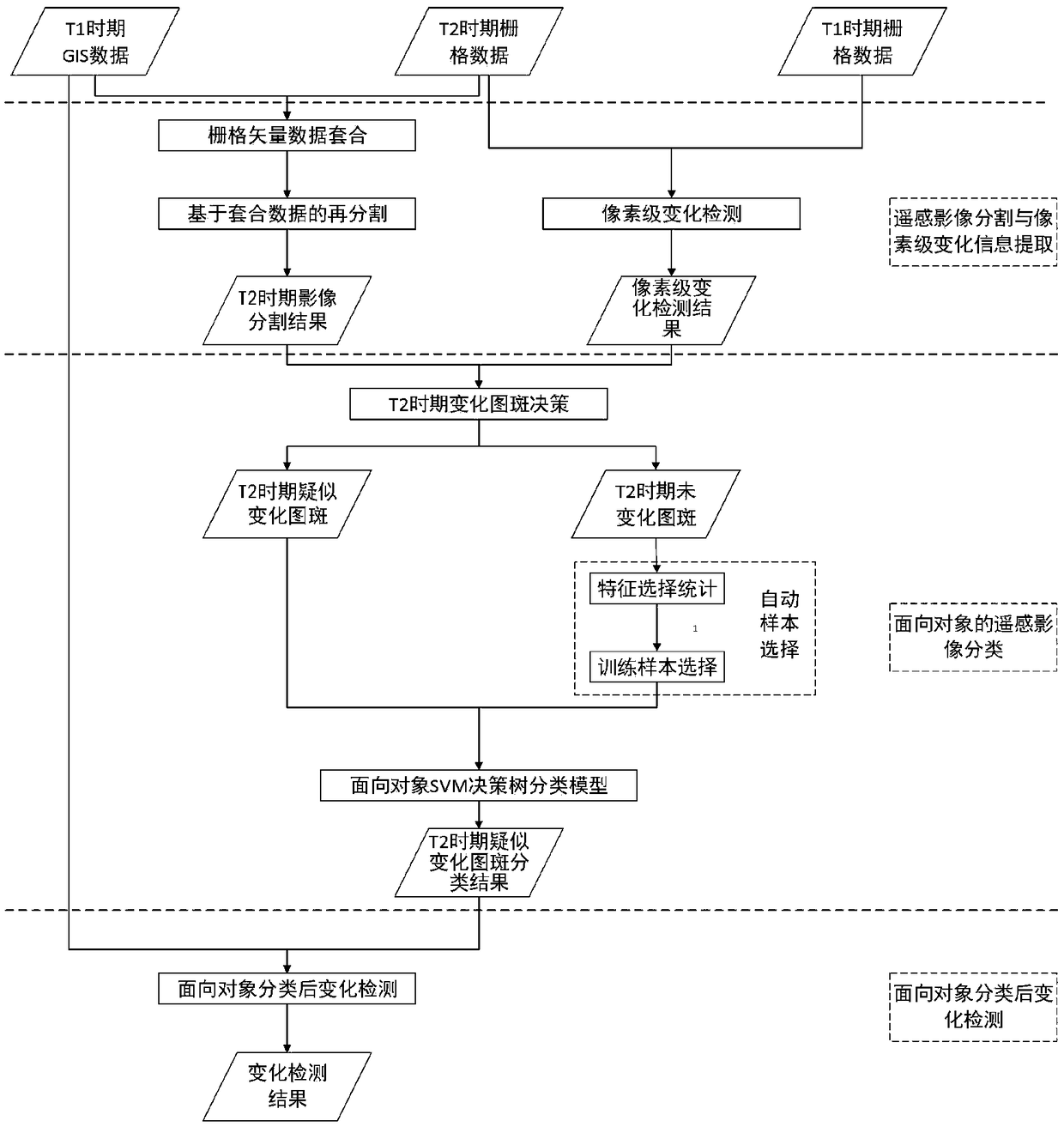
[0046] Below in conjunction with accompanying drawing and specific algorithm describe in detail the specific embodiment of the present invention, as figure 1 As shown, an object-oriented automatic detection method for change information based on multi-temporal remote sensing images and GIS data, the steps are as follows:

[0047] 1. Remote sensing image segmentation and pixel-level change information extraction

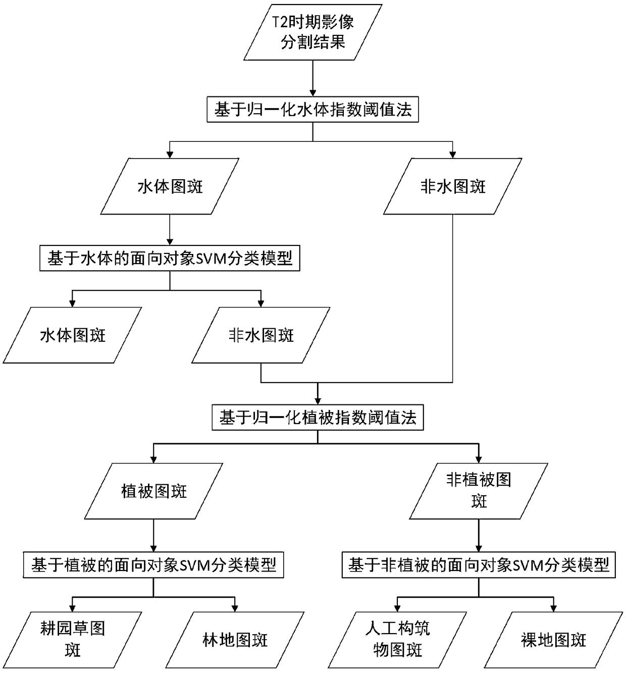
[0048] This step is mainly to use GIS vector data and multi-scale segmentation algorithm to segment the raster data in T2 period to obtain map spot information. Pixel-level change detection results.

[0049] 1.1. Remote sensing image segmentation

[0050] 1.1.1. Raster and vector data fit

[0051] According to the GIS vector data in the T1 period and the raster data in the T2 period, the raster data in the T2 period is combined by using the category attribute information and geometric shape information of the GIS vector data to obtain the grid corresponding to the ...


PUM


Abstract

The invention discloses a method and a system for change detection based on a multi-temporal remote sensing image and GIS data. The method is aimed at solving problems existing in segmentation, classification and change detection methods based on multi-temporal images and GIS data. The method includes the following steps: step 1, segmentation of a remote sensing image and extraction of pixel-levelchange information, mainly including remote sensing image segmentation and pixel-level change detection; step 2, object-oriented remote sensing image classification, mainly including change polygon decision, automatic sample selection and object-oriented SVM decision tree classification model; step 3, change detection after the object-oriented classification. Compared with existing methods of extracting change information using remote sensing images and GIS data, the method can realize automatic and large-area application change information detection method flow, can fully excavate relationship between remote sensing images and GIS data, utilizes attribute information such as type of the GIS data, and improves accuracy of change information extraction.

Description

technical field [0001] The present invention relates to the field of remote sensing and geographic information system (GIS, Geographic Information System), in particular to a method for automatically detecting changes in remote sensing images and GIS data, and in particular to an object-oriented automatic detection of change information using multi-temporal remote sensing images and GIS data Methods. Background technique [0002] In the field of remote sensing, change detection is the process of using remote sensing images of different time phases in the same area to obtain the changed area by comparing the differences in spectral reflectance, texture and other characteristics. Change detection using remote sensing images has been widely used in environmental monitoring, agricultural surveys, urban expansion studies, disaster monitoring, damage assessment and other fields. In the field of GIS, GIS data is the symbolic expression of surface features and features, and is the ...

Claims


Application Information

Patent Timeline
IPC IPC(8): G06T7/00G06T7/11G06T7/136G06K9/00G06K9/62G06F17/30
CPCG06T7/0002G06T7/11G06T7/136G06T2207/10032G06T2207/20081G06V20/13G06F18/2411
Inventor 史文中李振轩张敏张芮陈善雄占昭
Owner POLYU RES BASE SHENZHEN
Why Eureka
Try Eureka