A submarine line detection method based on side-scan sonar data fusion and precision processing
A technology of data fusion and side-scan sonar, which is applied in the direction of sound wave reradiation, radio wave measurement system, measurement device, etc., can solve the problems such as the complex implementation process of LOG operator submarine line extraction, and achieve the effect of solving the complex implementation process
- Summary
- Abstract
- Description
- Claims
- Application Information
AI Technical Summary
Problems solved by technology
Method used
Image

Examples
Embodiment 1
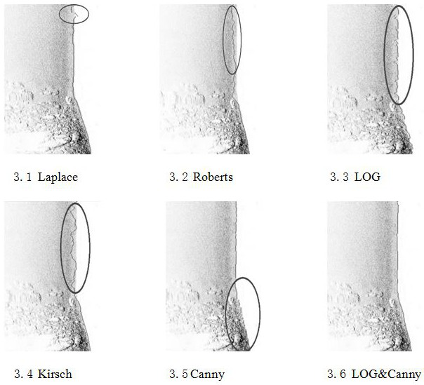
[0082] Embodiment 1 Comparative Analysis of Edge Detection Algorithms
[0083] By comparing five edge detection algorithms such as Laplace, Roberts, Kirsch, Canny, and LOG to analyze their advantages and disadvantages, it is verified that when the noise in the water column area is weak, the simple edge detection algorithm can monitor the seabed line better. Wherein the method effect of LOG&Canny combination of the present invention is better.
[0084] Table 1 time comparison of each method
[0085]
[0086] Table 1 records the time required for each method to run. This method can calculate the result in about 0.5s, which ensures the accuracy while also ensuring the efficiency. Although the latter methods have improved in time, they cannot guarantee Accuracy of bottom line detection.
[0087] image 3 , it can be seen that the detection effects of Kirsch algorithm, Roberts algorithm, Laplace algorithm, LOG algorithm, and Canny algorithm increase sequentially. The Kirsch ...
Embodiment 2
[0092] Embodiment 2 Implementation process of a submarine line detection method based on side-scan sonar data fusion and precision processing
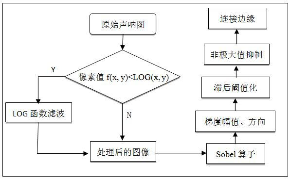
[0093] step1: Convert the sound wave intensity to gray scale. Decode the XTF data to generate a grayscale file;
[0094] step2: Load the image. Build a Bitmap type variable and load a complete single-strip submarine sonar image f(x,y);
[0095] step3: Image filtering. Calculate LOG(x, y) using formula (2) to filter and denoise the original sonar image f(x, y), and obtain the image f'(x, y) after removing the Gaussian noise of the image;
[0096] step4: image sharpening. The edge strength of the image will be reduced during the filtering process in step 3, so Laplacian is used to sharpen the image to obtain f″(x,y);
[0097] step5: Gradient amplitude and direction angle calculation. Use the Sobel first-order differential template to calculate the gradients in the horizontal and vertical directions, and use formulas (3) and (4) to ca...
Embodiment 3
[0102] Example 3 Specific application and comparison in Shenzhen Dapeng Bay sea area
[0103] The experiment adopts the survey data of Shenzhen Dapeng Bay sea area, and uses dual-frequency side-scan sonar equipment to simultaneously collect high-frequency (high-resolution, span 2*75m) and low-frequency (normal resolution, span 2*200m) two 100% overlap of adjacent track line measurement results, which are carried out synchronously with single-beam sounding, and 171 survey lines have been completed. The SSS instrument is Edgetech 4200FS, the frequency is 385KHz, and the single-beam sounder model is HY1600. The range of survey area is as Figure 7 As shown, the water depth variation in the survey area is 5-15m. There are not many types of geomorphology in the survey area, but there are many in number, mainly including: sand spots, fishing nets, sand pits, anchor trenches (anchor marks), reefs, etc.
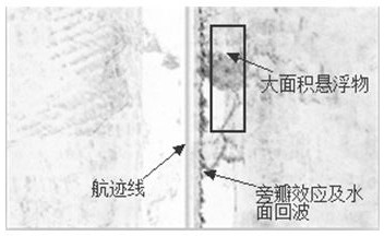
[0104] Select the area with high noise in the water column area of the sonar...
PUM
 Abstract
Description
Claims
Application Information
 - R&D
- Intellectual Property
- Life Sciences
- Materials
- Tech Scout
- Unparalleled Data Quality
- Higher Quality Content
- 60% Fewer Hallucinations
Browse by: Latest US Patents, China's latest patents, Technical Efficacy Thesaurus, Application Domain, Technology Topic, Popular Technical Reports.
© 2025 PatSnap. All rights reserved.Legal|Privacy policy|Modern Slavery Act Transparency Statement|Sitemap|About US| Contact US: help@patsnap.com