Atmospheric correction method for infrared channel of common-caliber high-rail remote sensing satellite

A remote sensing satellite and atmospheric correction technology, applied in the field of remote sensing image processing, can solve problems such as difficulty in real-time atmospheric correction, unfavorable commercial application of common aperture high-orbit remote sensing images, etc. Effect

Active Publication Date: 2018-11-27
BEIJING INST OF SPACECRAFT SYST ENG
View PDF10 Cites 12 Cited by
  • Summary
  • Abstract
  • Description
  • Claims
  • Application Information

AI Technical Summary

Problems solved by technology

Because water vapor changes frequently in space and time, it brings great difficulties to real-time atmospheric correction
The existing technology fails to effectively use the thermal infrared split window image to perform real-time atmospheric

Method used


Image

  • Atmospheric correction method for infrared channel of common-caliber high-rail remote sensing satellite
  • Atmospheric correction method for infrared channel of common-caliber high-rail remote sensing satellite
  • Atmospheric correction method for infrared channel of common-caliber high-rail remote sensing satellite

Examples


Embodiment Construction

[0035] The present invention will be described in detail below in conjunction with the accompanying drawings and specific embodiments.

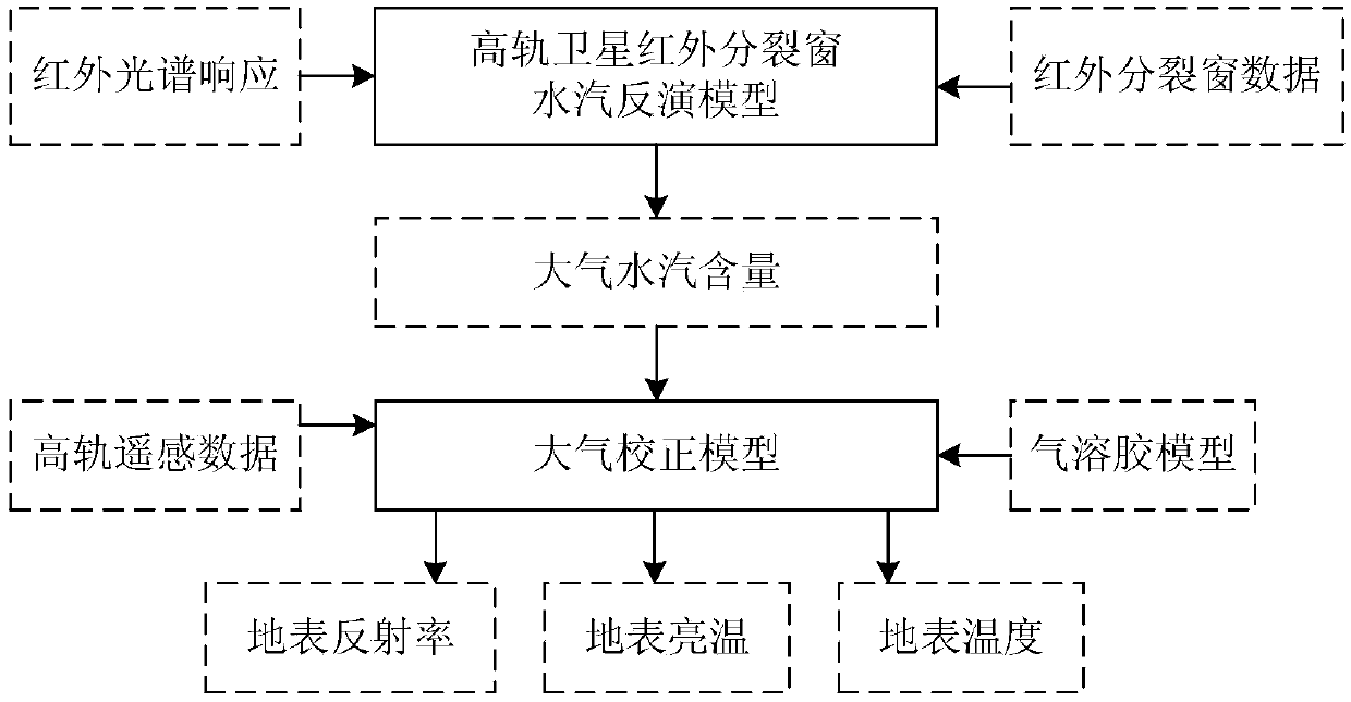
[0036] High-orbit remote sensing satellites have designed split-window channels in the thermal infrared band. Theoretically, for two thermal infrared bands with different water vapor absorptivity, the difference in the brightness temperature images can be used to estimate the water vapor content of the entire atmospheric column. Based on this principle, the present invention proposes an atmospheric correction method for the infrared channel of a common-aperture high-orbit remote sensing satellite.

[0037] Such as figure 1 As shown, taking the imaging data of high-orbit remote sensing satellites as an example, a method for atmospheric correction of infrared channels of common aperture high-orbit remote sensing satellites proposed by the present invention includes the following steps:

[0038] (1), by thermal infrared absorption channel B 1...


PUM


Abstract

The invention discloses an atmospheric correction method for an infrared channel of a common-caliber high-rail remote sensing satellite. The method comprises: step one, constructing an atmospheric vapor inversion model of a high-rail thermal-infrared split window and carrying out calculation to obtain an atmospheric column vapor content W of an image coverage area at a satellite imaging time; steptwo, according to atmospheric correction coefficients of all visible-near-infrared channels of a high-rail remote sensing satellite under different imaging conditions and atmospheric conditions, forming an atmospheric correction coefficient look-up table; step three, retrieving the atmospheric correction coefficient look-up table to obtain an atmospheric correction coefficient and calculating surface reflectances of all visible-near-infrared channels of the satellite to complete atmospheric correction of a visible-near-infrared band; step four, calculating atmospheric transmissivity values tau 11 and tau 12 of a thermal infrared absorption channel B11 and a transmission channel B12; and step five, completing surface temperature inversion by using an thermal infrared split window surface temperature inversion model, thereby obtaining a surface temperature. With the method disclosed by the invention, the satellite image quality as well as the remote sensing observation accuracy of the surface radiation amount and the reflection amount is improved.

Description

technical field [0001] The invention relates to an atmospheric correction method for an infrared channel of a common-aperture high-orbit remote sensing satellite, which is used for improving image quality and belongs to the technical field of remote sensing image processing. Background technique [0002] When high-orbit satellites image the earth, in addition to the visible spectrum, there are also medium / long-wave infrared spectrums to observe ground targets at the same time. Since the three channels share the front-end optical system, the same area can be imaged simultaneously, so the images of the three channels have high time, space and spectral correlation. Through radiometric inversion of the infrared spectrum images of the medium-wave infrared and long-wave infrared channels, the data related to the atmospheric influence at the imaging moment can be analyzed, thus providing an analysis basis for the visible light channel to eliminate the atmospheric influence and impr...

Claims


Application Information

Patent Timeline
IPC IPC(8): G01J5/00
CPCG01J5/00G01J2005/0077G01J5/804
Inventor 杨国巍孔祥皓陈卓一李果张胜王成伦刘凤晶王丽俐李响赵利民
Owner BEIJING INST OF SPACECRAFT SYST ENG
Why Eureka
Try Eureka