
Satellite-borne multi-spectral remote sensing image fusion method based on super-resolution enhancement

A remote sensing image fusion and multi-spectral image technology, which is applied in the field of spaceborne multi-spectral remote sensing image fusion based on super-resolution enhancement, can solve problems such as the inability to improve the resolution of multi-spectral images, and achieve improved spatial geometric resolution and wide application value. , the effect of reducing the difficulty of design

Inactive Publication Date: 2018-12-04
ACAD OF OPTO ELECTRONICS CHINESE ACAD OF SCI
View PDF3 Cites 11 Cited by
  • Summary
  • Abstract
  • Description
  • Claims
  • Application Information

AI Technical Summary

Problems solved by technology

Since the spatial resolution of the original multispectral image and the original panchromatic image are the same, it is impossible to improve the resolution of the multispectral image through traditional fusion methods. necessary

Method used


Image

  • Satellite-borne multi-spectral remote sensing image fusion method based on super-resolution enhancement
  • Satellite-borne multi-spectral remote sensing image fusion method based on super-resolution enhancement
  • Satellite-borne multi-spectral remote sensing image fusion method based on super-resolution enhancement

Examples


Embodiment Construction

[0022] The following describes the technical solutions in the embodiments of the present invention clearly and completely with reference to the accompanying drawings in the embodiments of the present invention. Obviously, the described embodiments are only a part of the embodiments of the present invention, rather than all the embodiments. Based on the embodiments of the present invention, all other embodiments obtained by those of ordinary skill in the art without creative work shall fall within the protection scope of the present invention.

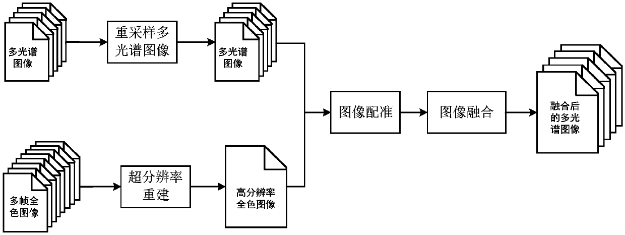
[0023] The embodiment of the present invention provides a space-borne multispectral remote sensing image fusion method based on super-resolution enhancement. According to the characteristics of "CX6(02)" high-resolution micro-nano satellite coagulation scanning imaging characteristics, a targeted super-resolution fusion enhancement scheme is designed, using only Panchromatic image sequences and multispectral image sequences with the same sp...


PUM


Abstract

The invention discloses a satellite-borne multi-spectral remote sensing image fusion method based on super-resolution enhancement. The method comprises: acquiring RGB multi-spectral images and carrying out re-sampling processing; acquiring multi-frame full-color images and performing super-resolution reconstruction to obtain a high-resolution full-color image; carrying image registration on each image among the resampled multi-spectral images and the high-resolution full-color image to obtain registered multi-spectral images; and carrying out feature conversion on the registered multi-spectralimages to obtain fused multi-spectral images. According to the method disclosed by the invention, the spatial geometric resolution of multi-spectral images can be improved and the optical system design difficulty can be reduced only by using the multi-spectral images and full-color image having the same spatial resolutions; and the micro-nano satellite multi-spectral remote sensing data have thegreat application value.

Description

Technical field [0001] The invention relates to the technical field of remote sensing data processing, in particular to a spaceborne multispectral remote sensing image fusion method based on super-resolution enhancement. Background technique [0002] Image fusion refers to the integration of multi-band information from a single sensor or multi-source heterogeneous data information provided by different sensors to make up for the shortcomings of a single data source and eliminate possible redundancy and contradictions between multi-sensor information to form A clear, complete and accurate information description of the target. An efficient image fusion method can comprehensively process multi-source data information as needed, thereby effectively improving image imaging quality, increasing the utilization of data information, increasing the reliability of target detection and recognition, and improving the robustness of the system. [0003] At present, image fusion has considerable...

Claims


Application Information

Patent Timeline
Patent Type & Authority Applications(China)
IPC IPC(8): G06T5/50G06T3/40G06T7/33G06K9/62
CPCG06T3/4061G06T5/50G06T7/337G06T2207/20221G06T2207/10036G06T2207/10041G06F18/2135G06F18/25
Inventor 孙建颖谭政吕群波尹增山赵娜李伟艳方煜刘扬阳高爽李平付
Owner ACAD OF OPTO ELECTRONICS CHINESE ACAD OF SCI
Learn More