A ship track data fusion method based on lstm model

A data fusion, ship technology, applied in the field of ship information perception and fusion, can solve the problem of unable to obtain target video information and surrounding environment information, unable to actively obtain specific target information, etc., to improve detection performance and reduce the loss of information. , the effect of improving the resolution

Active Publication Date: 2022-03-15
WUHAN UNIV OF TECH
View PDF5 Cites 0 Cited by
  • Summary
  • Abstract
  • Description
  • Claims
  • Application Information

AI Technical Summary

Problems solved by technology

However, AIS also has shortcomings. Since the device is characterized by passively receiving information, it cannot actively obtain specific target information; the ship position provided by AIS is only a coordinate point, and it cannot obtain target video information and surrounding environment information.
[0004] Therefore, AIS cannot be used as the only navigation and collision avoidance equipment during navigation

Method used


Image

  • A ship track data fusion method based on lstm model
  • A ship track data fusion method based on lstm model
  • A ship track data fusion method based on lstm model

Examples


Embodiment Construction

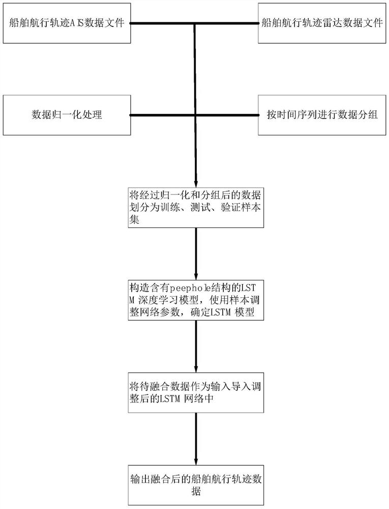
[0057] In order to facilitate those of ordinary skill in the art to understand and implement the present invention, the present invention will be described in further detail below in conjunction with the accompanying drawings and embodiments. It should be understood that the implementation examples described here are only used to illustrate and explain the present invention, and are not intended to limit this invention.

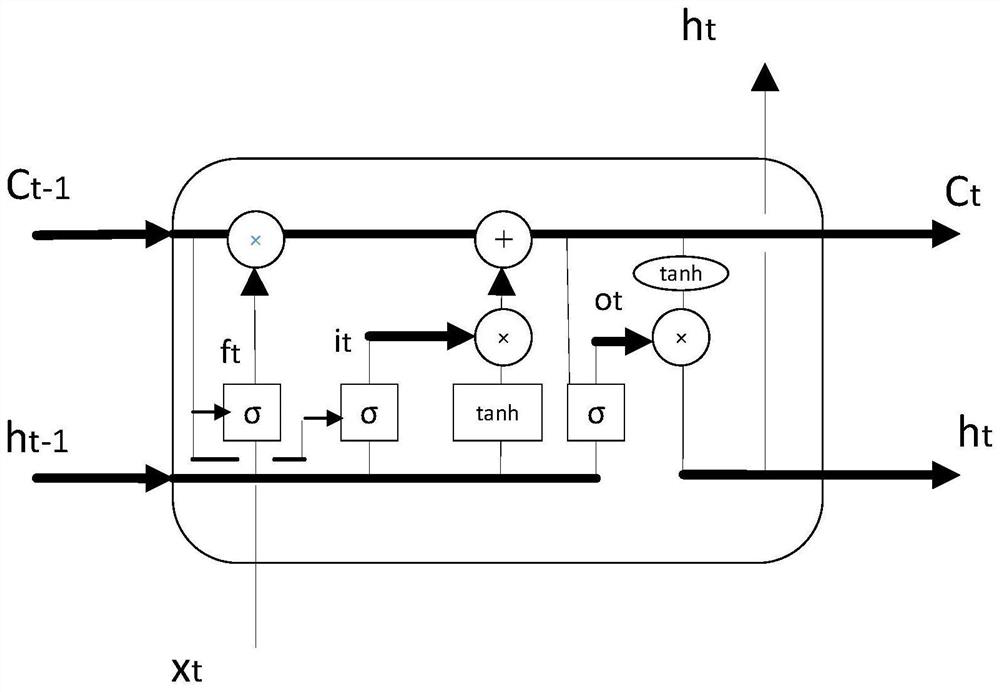
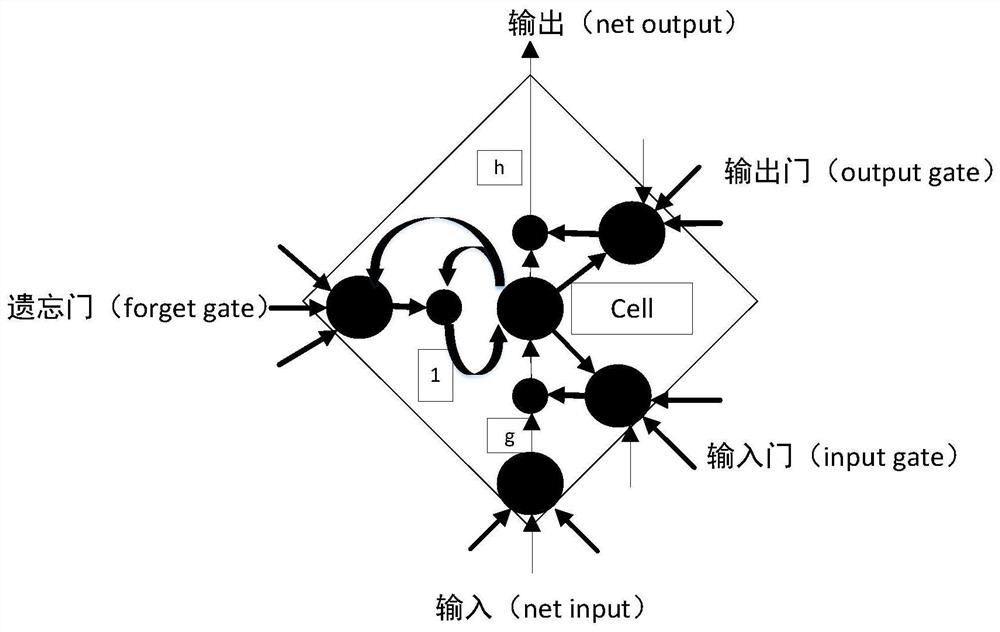
[0058] Combine below Figure 1 to Figure 3 Introduce the embodiment of the present invention, the embodiment of the present invention specifically includes the following steps:

[0059] Step 1: Collect the ship's voyage trajectory collected by the AIS system, ship-borne radar and high-precision GPS during a voyage as historical data, collect the dynamic latitude and longitude coordinate information of the ship during a period of voyage through the AIS system, and collect the ship's voyage information through the ship-borne radar The dynamic image coordinate ...


PUM


Abstract

The invention proposes a ship track data fusion method based on the LSTM model. The invention collects the ship's voyage trajectory collected by the AIS system, ship-borne radar and high-precision GPS during a voyage of the ship as historical data, collects the dynamic latitude and longitude coordinate information of the ship during a period of voyage through the AIS system, and collects the ship's voyage information through the ship-borne radar. The dynamic image coordinate information during a period of navigation is used as the training data; the radar latitude and longitude coordinate information, AIS coordinate information and high-precision GPS latitude and longitude coordinate information are respectively normalized; the normalized shipborne radar, AIS system and The coordinate information of the ship's navigation track collected by high-precision GPS is grouped to obtain the group coordinate information; the radar and AIS coordinate information after normalization and grouping is used as the training set to conduct preliminary training on the LSTM model, and then use the group-normalized high-precision GPS The coordinate information adjusts the weight parameters of the LSTM model. The invention has the advantage of improving the accuracy of ship track fusion.

Description

technical field [0001] The invention relates to the field of ship information perception and fusion, in particular to a ship track data fusion method based on an LSTM model. Background technique [0002] The world has entered the development period of "Industry 4.0", and made a key explanation on high-tech ships and ship intelligent manufacturing. Nowadays, with the rapid economic development and the rapid development of marine ships in the direction of technology and speed, the number of ships, especially the number of ships transporting dangerous goods, is increasing, and the density of ships is increasing. The above reasons directly lead to a sharp increase in safety hazards in maritime traffic. Occurs frequently, which not only makes life and property suffer a major threat, but also causes environmental pollution of the ocean to a large extent. In order to ensure the safety of maritime navigation and improve the efficiency of shipping management, the requirements for co...

Claims


Application Information

Patent Timeline
Patent Type & Authority Patents(China)
IPC IPC(8): G01S13/58G01S13/86G01S19/45
CPCG01S13/58G01S13/86G01S19/45
Inventor 谢磊陆楠楠张笛张金奋包竹薛双飞夏文涛
Owner WUHAN UNIV OF TECH
Why Eureka
Try Eureka