Navigation enhancement method and system based on low-orbit constellation

A low-orbit constellation and low-orbit satellite technology, applied in the field of satellite navigation, can solve the problems of accelerating the convergence of precise single-point positioning, low service coverage and availability, and insignificant changes in satellite space geometry, so as to reduce complexity and Cost, shorten the initialization time, and speed up the effect of the convergence speed

Active Publication Date: 2018-12-14
BEIJING FUTURE NAVIGATION TECH CO LTD
View PDF7 Cites 38 Cited by
  • Summary
  • Abstract
  • Description
  • Claims
  • Application Information

AI Technical Summary

Problems solved by technology

Since the convergence speed of the user's service accuracy is closely related to the geometric configuration of the navigation satellite space and the change rate of the geometric configuration, the augmented satellites of the above-mentioned systems are all in the middle and high orbits, and the angles that the satellites sweep across the zenith in a short period of time are small. The change in geometric configuration is not obvious, and the effect on accelerating the convergence of precise single-point positioning is limited. In the case of fixed ambiguity, the convergence time still needs at least 6 minutes, which cannot meet the current needs of high-precision real-time positioning.
[0004] The ground-based augmentation system and PPP+RTK technology can quickly achieve the rapid convergence of high-precision positioning, but limited by the layout of ground stations and communication links, the service coverage and availability are low, and cannot meet the needs of large-scale high-precision public applications

Method used


Image

  • Navigation enhancement method and system based on low-orbit constellation
  • Navigation enhancement method and system based on low-orbit constellation
  • Navigation enhancement method and system based on low-orbit constellation

Examples


Embodiment Construction

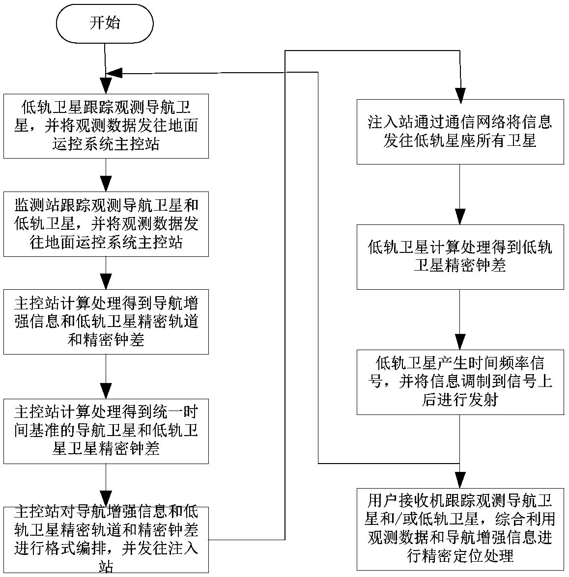
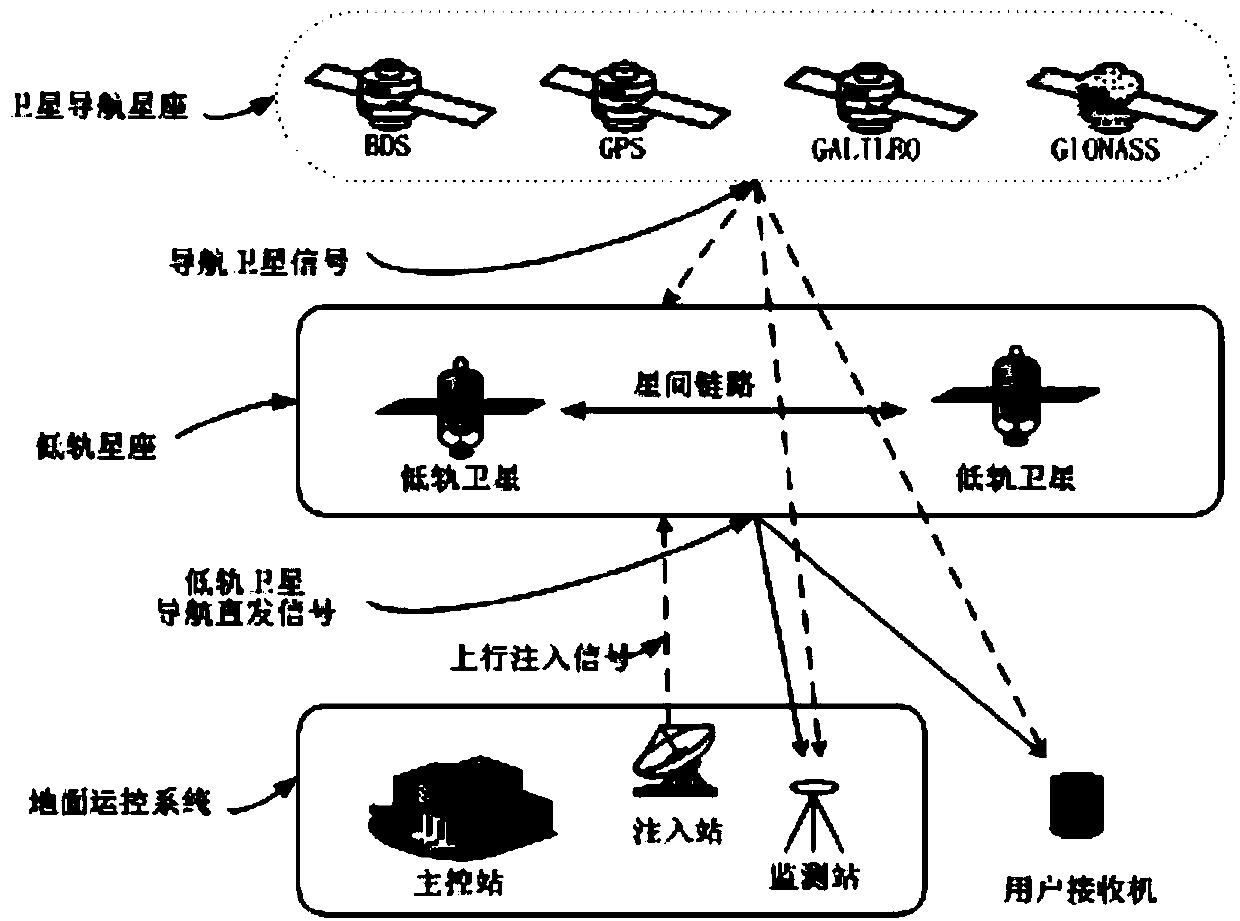
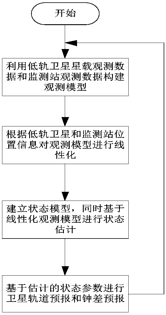
[0040] Exemplary embodiments of the present disclosure will be described in more detail below with reference to the accompanying drawings. Although exemplary embodiments of the present disclosure are shown in the drawings, it should be understood that the present disclosure may be embodied in various forms and should not be limited by the embodiments set forth herein. Rather, these embodiments are provided for more thorough understanding of the present disclosure and to fully convey the scope of the present disclosure to those skilled in the art.

[0041] Those skilled in the art can understand that, unless otherwise defined, all terms (including technical terms and scientific terms) used herein have the same meaning as commonly understood by those of ordinary skill in the art to which this invention belongs. It should also be understood that terms, such as those defined in commonly used dictionaries, should be understood to have meanings consistent with the meanings in the co...


PUM


Abstract

The invention provides a navigation enhancement method and system based on a low-orbit constellation. The method comprises the following steps: (a) broadcasting a navigation direct transmission signaland navigation enhancement information by using a low-orbit constellation satellite; (b) comprehensively utilizing the navigation direct transmission signals of the navigation satellite and the low-orbit satellite, and the navigation enhancement information to carry out precision location, speed measurement and timing by a user. The method can enhance the observation space geometrical configuration of the user by using the low-orbit satellite fast-moving feature and shorten the precise positioning initialization time of the user. The user receiver has the same hardware configuration as the universal satellite navigation receiver. Only needing to receive the direct transmission signals of the navigation satellite and the low-orbit satellite in one direction can rapid precise positioning beachieved, without needing to consider other data communication links. The navigation enhancement system comprises a low-orbit constellation, a ground control system and a user receiver. The system can achieve global coverage and provide the user with real-time precision positioning, speed measurement and timing services with high precision and high integrity.

Description

technical field [0001] The invention relates to the technical field of satellite navigation, in particular to a navigation enhancement method and system based on a low-orbit constellation. Background technique [0002] Existing global satellite navigation systems (GNSS), including Beidou, GPS, GLONASS, Galileo, etc., only provide users with navigation and positioning services better than 10 meters, which can no longer meet the needs of high-precision users. [0003] With the progress and development of core technologies such as real-time orbit and clock difference and precise point positioning technology, medium and high orbit satellite augmentation systems represented by Navcom's StarFire system and Fugro's OmniStar system have enabled the differential positioning system to reach a new level. stage. However, the above-mentioned system schemes are basically similar, and they all forward the enhanced information of the navigation system to the user terminal by renting a tran...

Claims


Application Information

Patent Timeline
Patent Type & Authority Applications(China)
IPC IPC(8): G01S19/10G01S19/07
CPCG01S19/07G01S19/10G01S19/073G01S19/02G01S5/14G01S19/46H04B7/19G01S19/11G01S19/256G01S19/51G01S19/55H04B7/18521
Inventor 穆旭成
Owner BEIJING FUTURE NAVIGATION TECH CO LTD
Why Eureka
Try Eureka