Dam settlement monitoring method based on high-score image and lifting/lowering orbit InSAR

A technology for settlement monitoring and lifting rails, which is used in height/level measurement, measuring devices, surveying and mapping, and navigation. Prospects, increasing speed and scope of monitoring, saving time and labor costs and the effect of project capital investment costs

Active Publication Date: 2018-12-18
湖南中科星图信息技术股份有限公司 +1
View PDF0 Cites 25 Cited by
  • Summary
  • Abstract
  • Description
  • Claims
  • Application Information

AI Technical Summary

Problems solved by technology

However, due to the obvious difference in the environment of the railway and the embankment, the correlation between this document and the present invention is different, the lifting rail is different, the observation object of the embankment is different, and the way of determining the weight is obviously different.

Method used


Image

  • Dam settlement monitoring method based on high-score image and lifting/lowering orbit InSAR
  • Dam settlement monitoring method based on high-score image and lifting/lowering orbit InSAR
  • Dam settlement monitoring method based on high-score image and lifting/lowering orbit InSAR

Examples


Embodiment Construction

[0029] Embodiments of the technical solutions of the present invention will be described in detail below in conjunction with the accompanying drawings. The following examples are only used to illustrate the technical solutions of the present invention more clearly, and therefore are only examples, rather than limiting the protection scope of the present invention.

[0030] The implementation of this case is as follows:

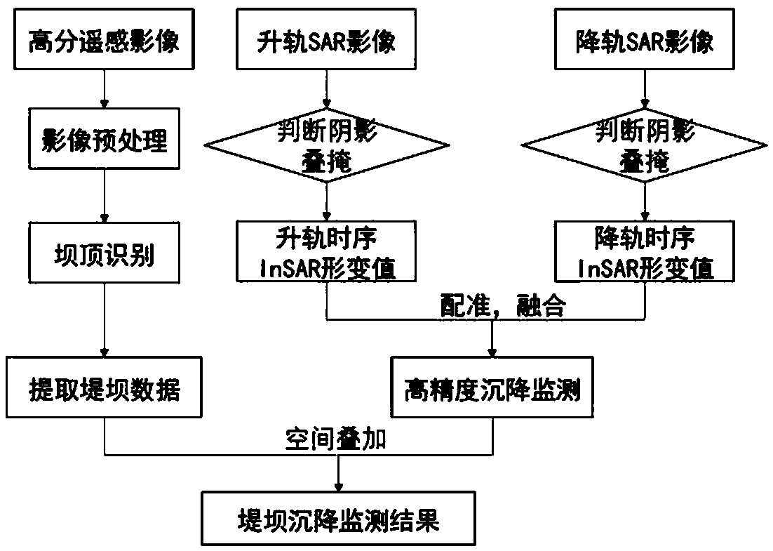
[0031]1. Location extraction of dams based on high-resolution images

[0032] Firstly, preprocessing such as radiometric correction and geometric correction is carried out on the image data of Gaofen 2. Since the dam crest is generally a road or cement concrete structure, it can be clearly distinguished in the remote sensing image, and then the dam crest data is obtained through semi-automatic interpretation. On this basis, the inner and outer slopes of the dam are extracted through manual vector editing, so as to obtain the precise geographical location and ...


PUM


Abstract

The invention relates to a dam settlement monitoring method based on high-score image and lifting/lowering orbit InSAR, comprising the following steps: A. dam position information extract: obtaining the high-definition image data of the dam by satellite to obtain the precise geographic position and range of the target dam surface; B. PS-InSAR deformation rate acquisition: using N SAR images acquired by satellite in the same area, selecting one SAR image as a main image, and generating a differential interferometric phase map by using DEM and orbital data to obtain DEM error and deformation rate; C. settlement rate calculation of the fused lifting/lowering orbit: according to the reflection characteristics of different regions of the dam and the geometrical distortion region, fusing the deformation monitoring method of the lifting/lowering orbit InSAR with different visual directions to obtain high-precision settlement information; and D. dam settlement information extract; performing spatial superposition operation on the obtained fused high-precision deformation field and the dam data extracted from the high-score image to obtain the settlement deformation information on the dam surface, thereby realizing the settlement monitoring of the dam.

Description

technical field [0001] The invention relates to the field of deformation monitoring in the surveying and mapping science and technology industry, and more specifically, relates to a method for identifying the range of a dam body through a high-resolution satellite optical image, and then using the SAR image of the lifting rail to monitor the settlement of the dam based on PS-InSAR technology. Background technique [0002] Drought and flood disasters occur frequently around the lake, and there are many unstable factors in the surrounding river embankments and dam embankments, and dam breaks, bank breaks, and mouth breaches occur from time to time. At present, the main means of monitoring and early warning of dams is to obtain various data of dams through manual measurement or sensor technology. Manual measurement requires a lot of labor time and professional technicians to monitor the dam for a long time; and the application of sensor technology requires a lot of money to bui...

Claims


Application Information

Patent Timeline
Patent Type & Authority Applications(China)
IPC IPC(8): G01C5/00G01S13/90
CPCG01C5/00G01S13/9023
Inventor 李建辉甘洁张贵谭三清罗望军俞友良
Owner 湖南中科星图信息技术股份有限公司
Why Eureka
Try Eureka