Airborne system and method for detection, localization and image acquisition of buried objects, method of characterizing subsoil composition

A technology of airborne system and positioning system, which is applied in multiple system fields to achieve good target detection effect

Inactive Publication Date: 2021-05-07
UNIVERSITY OF OVIEDO +1
View PDF13 Cites 0 Cited by
  • Summary
  • Abstract
  • Description
  • Claims
  • Application Information

AI Technical Summary

Problems solved by technology

Although the accuracy of reconstructing soil layer parameters is high even in the case of highly heterogeneous soils, the main disadvantage is the need to train characteristic algorithms, which, in addition to restricting the algorithm to a specific GPR system, requires that the real conditions in many different cases be considered under a large number of training measurements (applying the algorithm in another GPR system will require building a new database)

Method used


Image

  • Airborne system and method for detection, localization and image acquisition of buried objects, method of characterizing subsoil composition
  • Airborne system and method for detection, localization and image acquisition of buried objects, method of characterizing subsoil composition
  • Airborne system and method for detection, localization and image acquisition of buried objects, method of characterizing subsoil composition

Examples


example 1

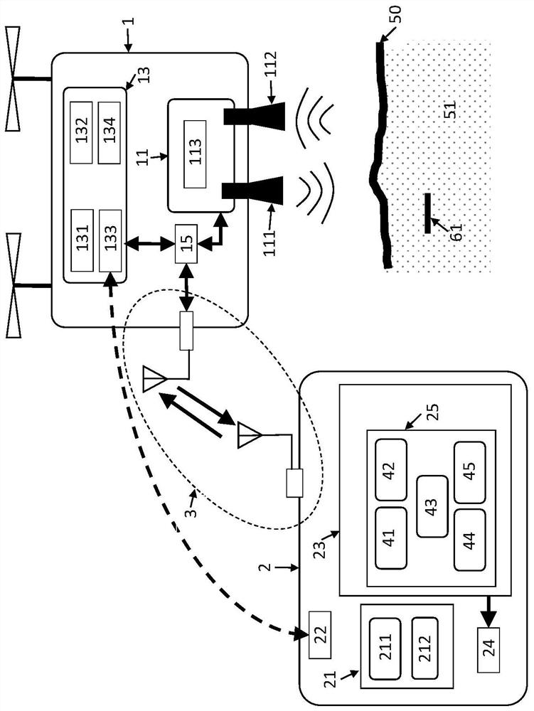
[0155] A first embodiment of the invention is based on the use of a single flight module (1) consisting of an unmanned aerial vehicle, in particular a multi-rotor aircraft, more specifically an octo-rotor aircraft, and its corresponding controller and battery pack . The octorotor used together with the controller and batteries has a maximum take-off weight of 6 kg and a payload capacity of 1.5 kg. This payload capacity is used to fit and integrate the following elements into the octocopter:

[0156] - flight control unit (15), implemented using a microcontroller (Raspberry Pi type) and programmed to collect information, control flight parameters of the flight module (1) from the radar unit (11) and the positioning and guidance system (13), And exchange information with the ground station (2). The octocopter includes a three-axis stabilization system mounted with a radar unit (11) to partially compensate for oscillations generated during flight.

[0157] - IEEE 802.11 (Wi-Fi...

example 2

[0168] For this example, the system described in Example 1 was used, but the helical receiver antenna (112) was replaced by a two-element array receiver antenna (112): one consisting of a right-handed circularly polarized helical antenna, Another element consisting of a left-handed circularly polarized helical antenna, both with gain and S11 similar to the transmit antenna. Each element of the array is connected to a switch that allows acquisition of the received radar signal in one element of the array or another element of the array.

example 3

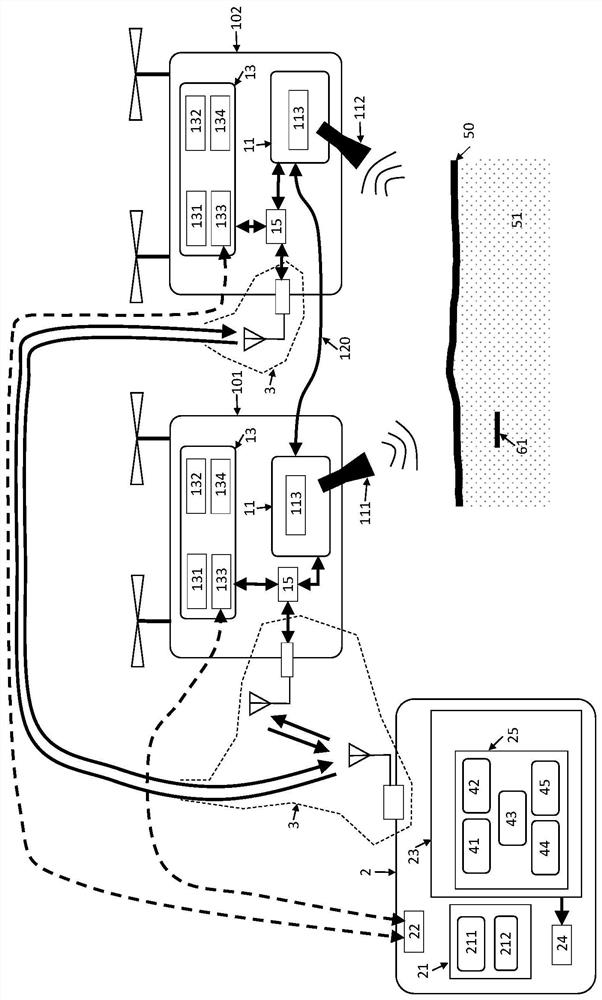
[0170] To achieve this, a system similar to that described in Example 1 is used, but with two flight modules (octorotors): the flight module (1), which is a flight launcher with a radar unit (11) that transmits radar signals a receiver module (101); and another flight module (1), which is a receiver flight module (102) with a radar unit (11) for capturing radar signals.

[0171] The synchronization between the transmitter flight module (101) and the receiver flight module (102) is realized through the communication device, and the communication device includes the radar module (113) on the transmitter flight module (101) and the receiver flight module (102) A real-time two-way radar communication system (120) between the radar modules (113) on the system. The communication system is included within the functionality of the radar module (113) (PulsOnP410) so that this existing functionality can be used to extend the system to multistatic mode.

[0172] Position the transmitter...


PUM


Abstract

The present invention relates to airborne systems and methods for detection, localization and image acquisition of buried objects and characterization of subsoil composition. The system comprises at least one flight module (1) with a radar unit (11) for emitting and / or capturing radar signals and a positioning and guidance system (13) with an accuracy equal to or less than three centimeters and a ground station (2). ), the ground station (2) has a flight control system (21) and a radar signal processing unit (23) to which a radar signal processing algorithm (25) is applied. The invention also relates to methods for detecting, locating and imaging buried objects, and methods for characterizing subsoil composition. The invention is suitable for use in areas where detection of buried objects is required, for example in civil applications (detection of anti-personnel mines), pipeline inspection or in archaeology.

Description

technical field [0001] The present invention relates to systems for acquiring images of any buried object of any composition and characterizing the composition of the subsoil. A system includes at least one transmitter flight module and receiver flight module, a ground station, and a communication system between the elements. Another system is similar to the aforementioned system, but it includes at least one transmitter flight module and another receiver flight module. The invention also relates to a radar signal processing method for acquiring radar images of the subsoil and of possible objects buried in the subsoil, including detection and localization of the objects, and for characterizing the composition of the subsoil. [0002] The invention is suitable for use in those areas where detection of buried objects is required, eg for civil applications in mine detection, pipeline detection, archaeology or hole or cavity detection. Background technique [0003] The detecti...

Claims


Application Information

Patent Timeline
Patent Type & Authority Patents(China)
IPC IPC(8): F41H11/13G01S13/88
CPCG01S13/88G01S13/904G01S13/9076B64C39/024F41H11/136B64U2101/30F41H11/13G01S13/885B64U30/20B64U2201/20B64U2201/104G01C11/00G01S7/003G01S7/40G01S19/43
Inventor 博尔哈·冈萨雷斯·巴尔德斯尤里·阿尔瓦雷斯·洛佩斯安娜·阿尔博莱亚尤兰达·罗德里格斯·瓦凯罗玛利亚·加西亚·费尔南德斯费尔南多·拉斯-埃拉斯·安德烈安东尼奥·加西亚·皮诺
Owner UNIVERSITY OF OVIEDO
Why Eureka
Try Eureka