Method and apparatus for mapping river course map to web map

A map and river channel technology, which is applied in graphics and image conversion, image analysis, image data processing, etc., can solve problems such as two-dimensional map registration errors, and achieve accurate registration results

Active Publication Date: 2019-01-04
广州市鑫广飞信息科技有限公司
View PDF3 Cites 5 Cited by
  • Summary
  • Abstract
  • Description
  • Claims
  • Application Information

AI Technical Summary

Problems solved by technology

However, due to compression deformation in the process of drawing a 3D map into a 2D map, there will be some errors in the registration of the 2D map with the actual latitude and longitude

Method used


Image

  • Method and apparatus for mapping river course map to web map
  • Method and apparatus for mapping river course map to web map
  • Method and apparatus for mapping river course map to web map

Examples


Embodiment Construction

[0045] The following will clearly and completely describe the technical solutions in the embodiments of the present invention with reference to the accompanying drawings in the embodiments of the present invention. Obviously, the described embodiments are only some, not all, embodiments of the present invention. Based on the embodiments of the present invention, all other embodiments obtained by persons of ordinary skill in the art without making creative efforts belong to the protection scope of the present invention.

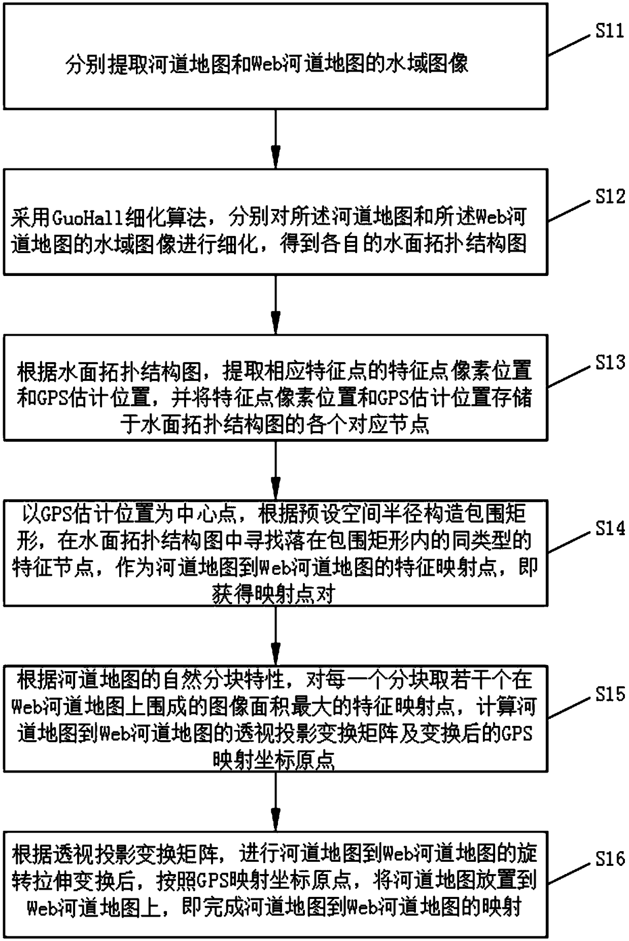
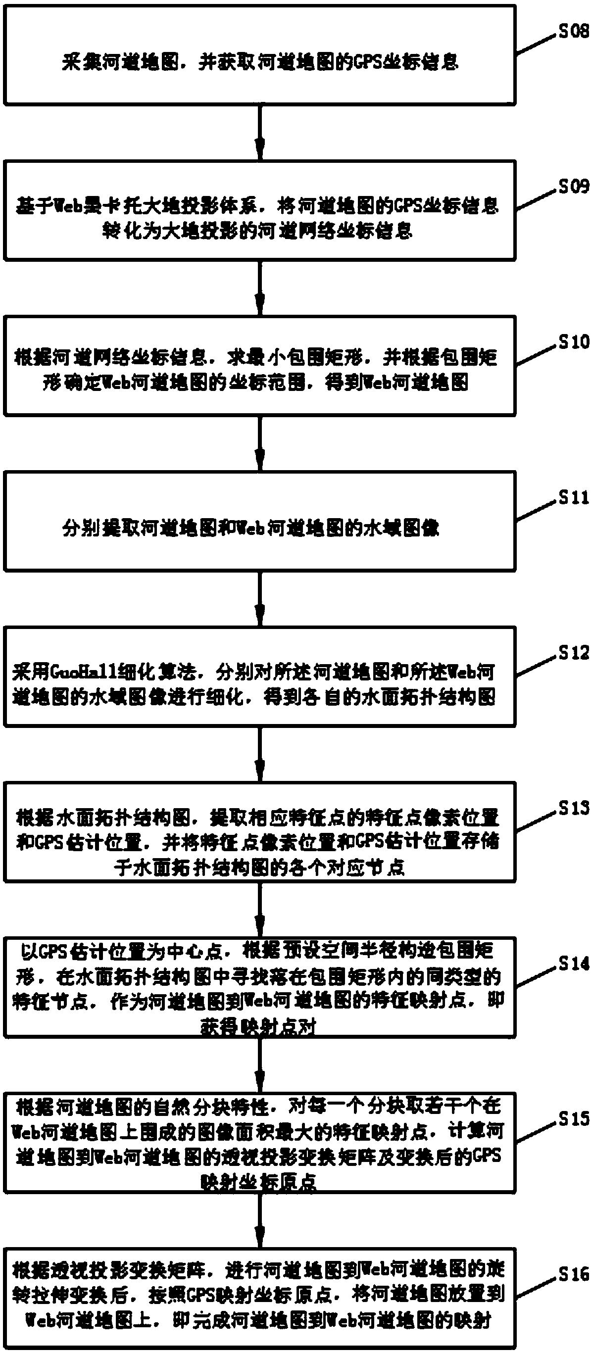
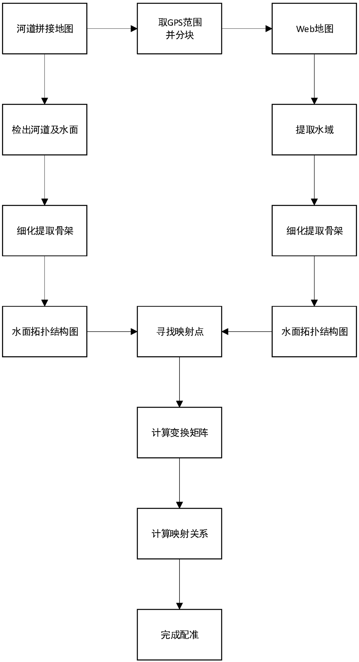
[0046] see figure 1 .

[0047] like figure 1 As shown, the method for mapping a river course map to a Web map provided by an embodiment of the present invention includes:

[0048] S11, extracting the water area images of the river course map and the Web river course map respectively.

[0049] S12. Using the GuoHall thinning algorithm, respectively thinning the water area images of the river channel map and the Web river channel map to obtain respective water ...


PUM


Abstract

The invention discloses a method and a device for mapping a river course map to a Web map. The method comprises the following steps: water area images of a river course map and a Web river course mapare respectively extracted; the topological structure of water surface is obtained by a thinning algorithm; according to the surface topology map, the pixel positions of the feature points and the GPSestimated positions are extracted, and the pixel positions of the feature points and the GPS estimated positions are stored in the corresponding nodes of the surface topology map; the pixel positionsof the feature points and the GPS estimated positions of the feature points are extracted from the surface topology map; a mapping point pair is obtained through a corresponding node; the transformation matrix of perspective projection from river map to Web river map and the origin of GPS mapping after transformation are calculated by using mapping point pairs; a perspective projection transformation matrix is used to complete the mapping from a river map to a Web river map. By adopting the invention, the accurate registration of the real geographical environment and the Web map can be realized.

Description

technical field [0001] The invention relates to the technical field of map registration, in particular to a method and a device for mapping a river map to a Web map. Background technique [0002] At present, positioning systems are widely used in plane maps, such as Baidu Maps and Gaode Maps, etc., but such maps cannot accurately and intuitively and clearly reflect the pattern and topography of the real geographical environment, and the user experience is not ideal. [0003] In order to solve the above problems, in the prior art, a two-dimensional map formed after compression and projection of a three-dimensional map is usually used to reflect the real geographical environment. However, since there will be compression deformation in the process of drawing the three-dimensional map into a two-dimensional map, there will be certain errors in the registration between the two-dimensional map and the actual latitude and longitude. Contents of the invention [0004] The technic...

Claims


Application Information

Patent Timeline
Patent Type & Authority Applications(China)
IPC IPC(8): G06T3/00G06T3/40G06T7/33
CPCG06T3/0031G06T3/4038G06T7/33
Inventor 沈伟李瑞程
Owner 广州市鑫广飞信息科技有限公司
Why Eureka
Try Eureka