Shipborne sandstone volume automatic computation method supporting real-time monitoring

A real-time monitoring and automatic calculation technology, applied in the field of geospatial information systems, can solve problems such as lack of calculation accuracy, large amount of data, and complex data scenarios

Active Publication Date: 2019-08-13
浙江中海达空间信息技术有限公司
View PDF11 Cites 15 Cited by
  • Summary
  • Abstract
  • Description
  • Claims
  • Application Information

AI Technical Summary

Problems solved by technology

[0003] In order to solve the above problems, the purpose of the present invention is to provide a real-time monitoring ship-borne sandstone volume automatic calculation method, the method for the floating platform to obtain point cloud data scene complex, large amount of data, using sample downsampling and The cluster analysis based on the preset seed points realizes the fast and accurate extraction of the target ship in the point cloud scene; considering the floating nature of the ship during transportation, the local feature error of the point cloud data is caused, the global feature is introduced, and the plane is used as the primitive Realize the automatic registration of point cloud data; considering the impact of the lack of ship point cloud data on the calculation accuracy of sand and gravel volume, the present invention uses the improved bilinear nearest neighbor interpolation algorithm to realize the repair of scanning data loopholes, thereby realizing the accuracy of ship transportation of sand and gravel. Real-time data collection, efficient transmission, accurate calculation

Method used


Image

  • Shipborne sandstone volume automatic computation method supporting real-time monitoring
  • Shipborne sandstone volume automatic computation method supporting real-time monitoring
  • Shipborne sandstone volume automatic computation method supporting real-time monitoring

Examples


Embodiment Construction

[0050] The preferred embodiments of this patent will be described in further detail below in conjunction with the accompanying drawings.

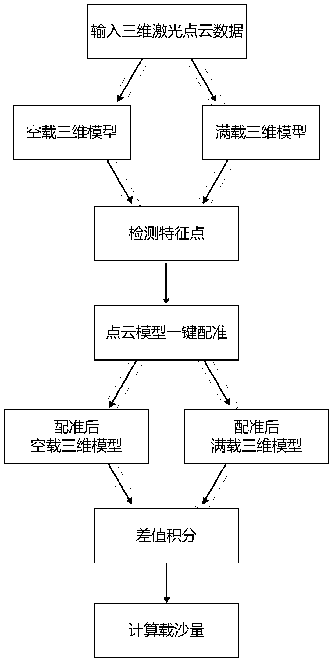
[0051] The invention discloses a method for automatically calculating the volume of ship-borne sand and gravel supporting real-time monitoring, see figure 1 , the principle of this method is to obtain the 3D model of the empty ship and the 3D model of the fully loaded ship, detect and extract the feature point pairs of the point cloud data, and then realize the automatic registration of the high-precision point cloud, and finally according to the elevation of the empty and full ship point cloud data The value is integrated by the difference to calculate the sand load of the ship.

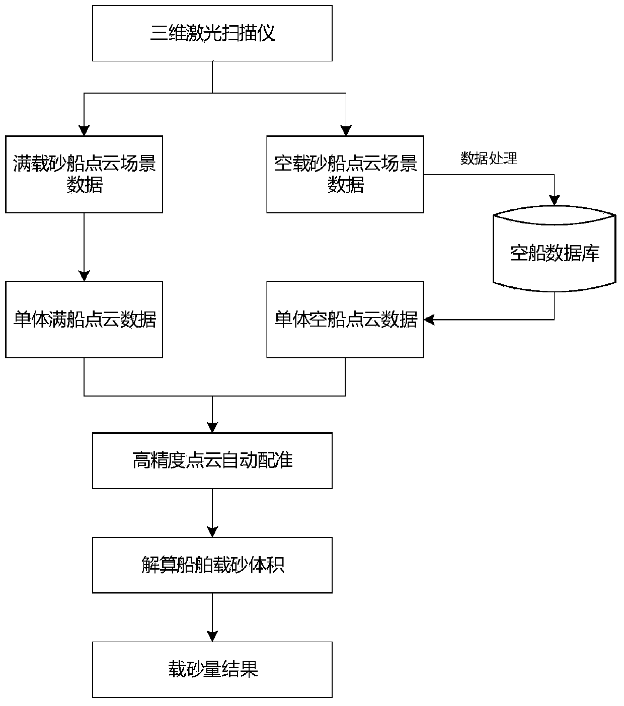
[0052] Overall technical process of the present invention is as figure 2 As shown, firstly, the point cloud data of the empty sand carrier is obtained by using the 3D laser scanner equipment, and the standardized processing and modeling are put into the warehou...


PUM


Abstract

The invention relates to a shipborne sandstone volume automatic computation method supporting real-time monitoring. The method comprises the following steps: configuring a three-dimensional laser scanner; scanning a no-load sand ship, automatically identifying to extracting a target monomer clean ship in scene point cloud data, performing point cloud loophole auto-patching, and establishing a no-load sand ship point cloud data model; scanning a fully-loaded sand ship, automatically identifying to extract the target monomer fully-loaded ship data in the scene point cloud data; performing high-precision automatic registering on the no-load and fully-loaded monomer sand ship point cloud data; extracting the cabin region data of the sand ship point cloud data at two stages, and resolving the volume of the ship sand transport quantity through elevation difference integral. The real-time collection, efficient transmission and precise computation on the ship sandstone transport data can be realized through the method disclosed by the invention.

Description

technical field [0001] The invention relates to the technical field of geospatial information systems, in particular to an automatic calculation method for ship-borne sandstone volume supporting real-time monitoring. Background technique [0002] The existing management methods in the sand mining and sand transportation industry are still at a relatively backward technical level. There is no accurate calculation method for the volume of sand excavated by ships, and the actual volume of the ship cannot be accurately measured by manual measurement of "draft level". . With the development of information technology and the continuous deepening of sand and gravel work, how to use 3S technology to automatically, quickly and accurately obtain the volume of sand and gravel has become an urgent problem to be solved. In the past ten years, with the rapid development of 3D lidar and multi-temporal point cloud registration technology, the large-scale point cloud data that can be quickl...

Claims


Application Information

Patent Timeline
Patent Type & Authority Applications(China)
IPC IPC(8): G01B11/00
CPCG01B11/00
Inventor 谢潇王登星张叶廷黄爽许飞
Owner 浙江中海达空间信息技术有限公司
Why Eureka
Try Eureka