Construction site comprehensive spatial monitoring system based on Beidou high-precision positioning and BIM

A construction site and space monitoring technology, applied in the field of monitoring systems, can solve problems such as high-rise or super high-rise building dynamics, high-precision mobility monitoring, etc., to reduce times and frequencies, improve construction accuracy, and reduce cumulative measurement errors Effect

Inactive Publication Date: 2019-01-08
NANTONG SIJIAN CONSTR GRP
View PDF1 Cites 14 Cited by
  • Summary
  • Abstract
  • Description
  • Claims
  • Application Information

AI Technical Summary

Problems solved by technology

Using this technology to establish a temporary origin in the construction area of ​​the building foundation pit, the error range is controlled at the millimeter level, but the equipment is all fixed during the entire monitoring process, which cannot meet the dynamic and mobile high-precision monitoring of high-rise or super high-rise buildings

Method used


Image

  • Construction site comprehensive spatial monitoring system based on Beidou high-precision positioning and BIM

Examples


Embodiment example

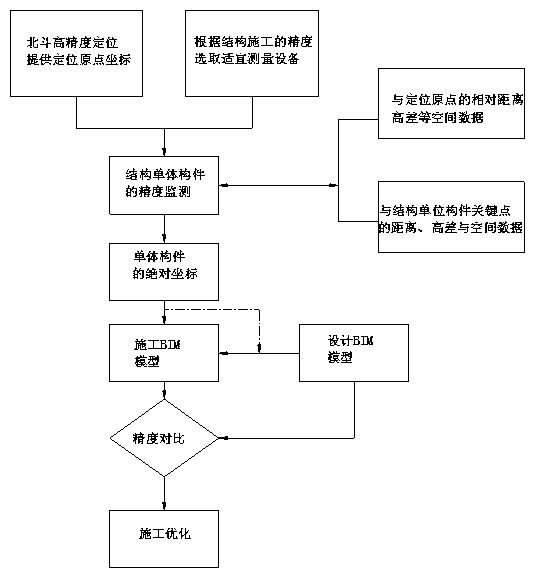
[0031] 1. According to the accuracy requirements of structural construction, select satellite positioning equipment with positioning accuracy that meets the requirements, and directly locate around the proposed residential building to determine the coordinates of the origin;

[0032] 2. Calculate the relative coordinates of the key nodes of the structure through the designed BIM model, and measure and locate the origin, the relative distance and height difference of the key points of the structural unit components by using the photoelectric rangefinder, total station and laser scanner;

[0033] 3. Through data exchange, calculate the absolute coordinates of the key nodes of the structure through the relative distance, height difference and origin coordinates between devices;

[0034] 4. Change the absolute coordinates of the design BIM model of the key structural nodes to the absolute coordinates calculated in step (3), and the design BIM is updated to the construction BIM mode...


PUM


Abstract

The invention discloses a construction site comprehensive spatial monitoring system based on Beidou high-precision positioning and BIM. The traditional survey mode is not satisfactory in survey accuracy and efficiency for construction projects with complex topography and large construction scale. By introducing Beidou high-definition positioning into the traditional measurement technology and combining with modern wireless transmission technology, the system establishes a mm-level comprehensive measurement system at the construction site. On this basis, the BIM technology is used to compare the spatial coordinates of the design model and the construction model, so as to realize the whole process precision control and scientific deviation correction of the construction site.

Description

technical field [0001] The invention relates to a monitoring system applied to civil engineering, construction engineering and water conservancy engineering, in particular to a construction site comprehensive spatial monitoring system based on Beidou high-precision positioning and BIM. Background technique [0002] Traditional construction surveys use total stations and photoelectric rangefinders to achieve precision control of buildings. Generally speaking, in low-rise buildings or ordinary high-rise buildings, the application of traditional measurement tools can meet the design requirements. But at this stage, underground projects and super high-rise buildings emerge in endlessly, and expressways and railways are common. Without exception, the above-mentioned projects have strict requirements on measurement accuracy. However, traditional measurement technology relies on optical measurement to continuously expand the measurement range, which leads to an increase in the num...

Claims


Application Information

Patent Timeline
Patent Type & Authority Applications(China)
IPC IPC(8): G06F17/50G06Q50/08G01S19/42
CPCG01S19/42G06Q50/08
Inventor 耿裕华徐卓李星星俞国兵陈建军周昕朱岭
Owner NANTONG SIJIAN CONSTR GRP
Why Eureka
Try Eureka