Driverless car travelling right of way planning method based on traffic rules constraint

An unmanned vehicle and right-of-way technology, applied in the directions of road network navigators, measuring devices, instruments, etc., can solve the problem of not considering the constraints of traffic rules and so on.

Active Publication Date: 2019-01-11
JIANGSU UNIV
View PDF4 Cites 6 Cited by
  • Summary
  • Abstract
  • Description
  • Claims
  • Application Information

AI Technical Summary

Problems solved by technology

[0004] Purpose of the invention: Aiming at the problem that the existing unmanned vehicle driving road environment modeling method does not consider the traffic rule constraints, the present invention proposes three types of constraints based on these traffic rule constrain...

Method used


Image

  • Driverless car travelling right of way planning method based on traffic rules constraint
  • Driverless car travelling right of way planning method based on traffic rules constraint
  • Driverless car travelling right of way planning method based on traffic rules constraint

Examples


Embodiment

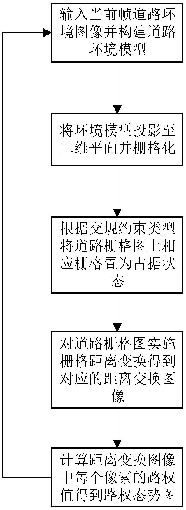
[0027] like figure 1 As shown, a method for planning the right of way for unmanned vehicles based on traffic regulations constraints in this embodiment includes the following steps:

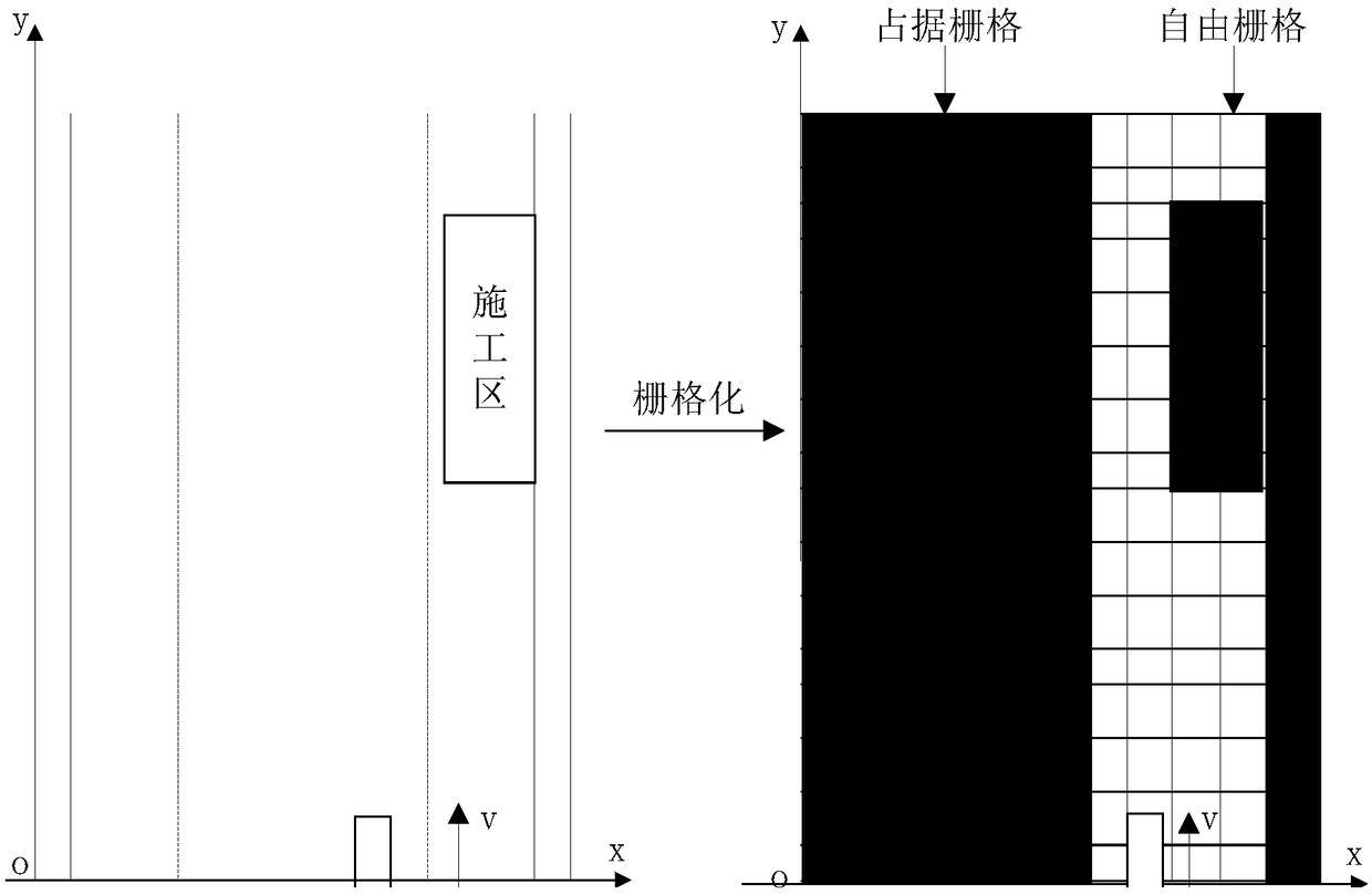
[0028] Step (1), converting the road environment image into a road top view and rasterizing the road top view, the specific steps are as follows:

[0029] For the road environment image collected by the binocular camera, the coordinates of any point in the pixel coordinate system are [u, v] T , then according to the perspective camera model, the coordinates P(X, Y, Z) of the space point P corresponding to the pixel in the world coordinate system can be obtained:

[0030]

[0031] In the formula, K is the internal parameter of the camera, and R, t is the external parameter of the camera.

[0032] Using formula (1), the point cloud data of the road environment can be calculated according to the road environment image, and the top view of the road can be obtained by projecting the point cloud d...


PUM


Abstract

The invention discloses a driverless car travelling right of way planning method based on traffic rules constraint. The method comprises the following steps: firstly, recovering a road environment model from a road environment image acquired by a camera, projecting the model to a two-dimensional plane and executing gridding; then, setting corresponding grids on a road grid map to be in an occupiedstate according to the type of the traffic regulation constraint; further performing grid distance conversion for the road grid map to obtain a corresponding distance conversion image; and finally, calculating a right of way value of each pixel in the distance conversion image to obtain a right of way situation map. By implementation of the method above, a driverless car is enabled to travel safely under the premise of obeying the traffic rules in regulated roads, and a problem that the traffic rules constraint is not considered in the existing driverless car travelling road environment modelling method is solved.

Description

technical field [0001] The invention belongs to the technical field of driving environment perception for unmanned vehicles, and in particular relates to a road right planning method for driving unmanned vehicles that introduces traffic rule constraints into a vehicle driving environment model. Background technique [0002] Unmanned driving technology mainly includes environmental perception technology, intelligent decision-making technology, path planning technology, control technology and vehicle architecture, among which environmental perception technology is the most basic and crucial component of the unmanned driving technology system. Technology uses sensors such as lidar and cameras to obtain information about the surrounding environment of the vehicle and build a model of the vehicle's driving environment, which is a necessary prerequisite for autonomous and safe driving of unmanned vehicles. [0003] In 2008, Kammel and Pitzer proposed an environment perception meth...

Claims


Application Information

Patent Timeline
IPC IPC(8): G01C21/34
CPCG01C21/3415G01C21/3446G01C21/3492
Inventor 汤传业赵鑫文蔡英凤陈建锋王海何友国陈龙江浩斌
Owner JIANGSU UNIV
Why Eureka
Try Eureka