
Satellite navigation receiver with improved ambiguity resolution

A satellite navigation and ambiguity technology, applied in satellite radio beacon positioning systems, instruments, measurement devices, etc., can solve the problems of not being stable, robust and accurate at the same time, achieve fast initialization time, reduce Dynamic range, the effect of mitigating potential numerical problems

Active Publication Date: 2019-01-11
DEERE & CO
View PDF9 Cites 0 Cited by
  • Summary
  • Abstract
  • Description
  • Claims
  • Application Information

AI Technical Summary

Problems solved by technology

However, current PPP-RTK systems usually do not have simultaneously stable, robust and accurate real-time integer ambiguity resolution with fast initialization time

Method used


Image

  • Satellite navigation receiver with improved ambiguity resolution
  • Satellite navigation receiver with improved ambiguity resolution
  • Satellite navigation receiver with improved ambiguity resolution

Examples


Embodiment Construction

[0016] The following specification describes, illustrates, and illustrates one or more specific embodiments of the invention in accordance with the principles of the invention. The description is provided not to limit the invention to the embodiments described herein, but to explain and teach the principles of the invention so that those of ordinary skill in the art can understand these principles and, based on that understanding, can apply them to not only Implement the embodiments described herein and implement other embodiments that may occur in light of these principles. The scope of the invention is intended to cover all such embodiments as may come within the scope of the appended claims either literally or under the doctrine of equivalents.

[0017] It should be noted that in the specification and drawings, similar or substantially similar elements may be labeled with the same reference numerals. However, sometimes these elements may be labeled with different reference...


PUM


Abstract

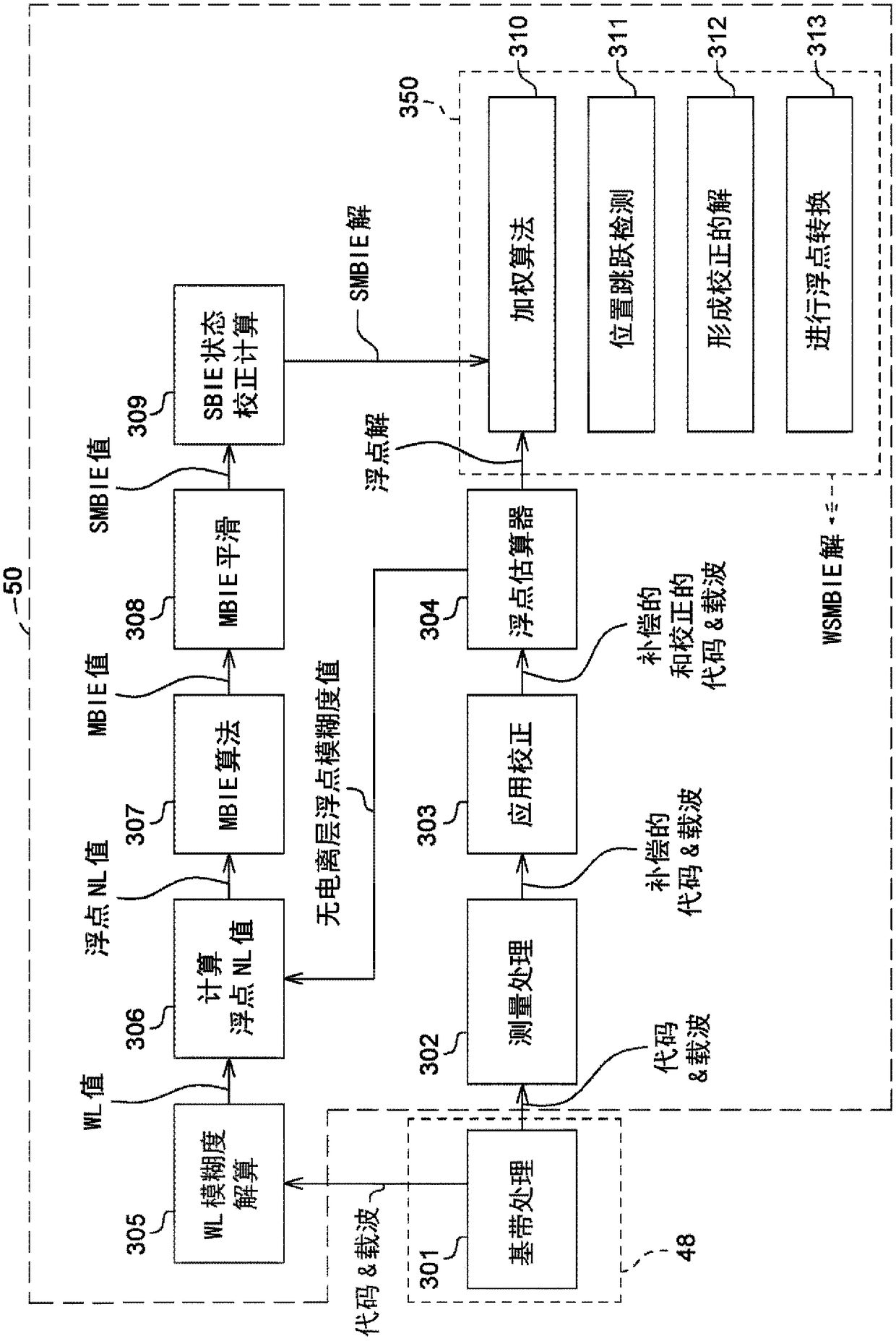
A satellite navigation receiver and associated methods are described that can provide improved integer ambiguity resolution and more accurate positioning information. A modified BIE process (307) maybe utilized to enable the receiver to perform the integer ambiguity resolution more optimally. The output of the modified BIE process may be time-domain smoothed (308) to provide a solution which is smoother in ambiguity space, and therefore also provide a position solution that is smoother in time. Transitions between an ambiguity-determined solution to a float solution, when necessary, may be smoothed in time. A weighting scheme (310) may dynamically blend the ambiguity-determined solution and the float solution to leverage the advantages of both solutions, such as faster pull-in, higher accuracy, and more stable and smooth performance.

Description

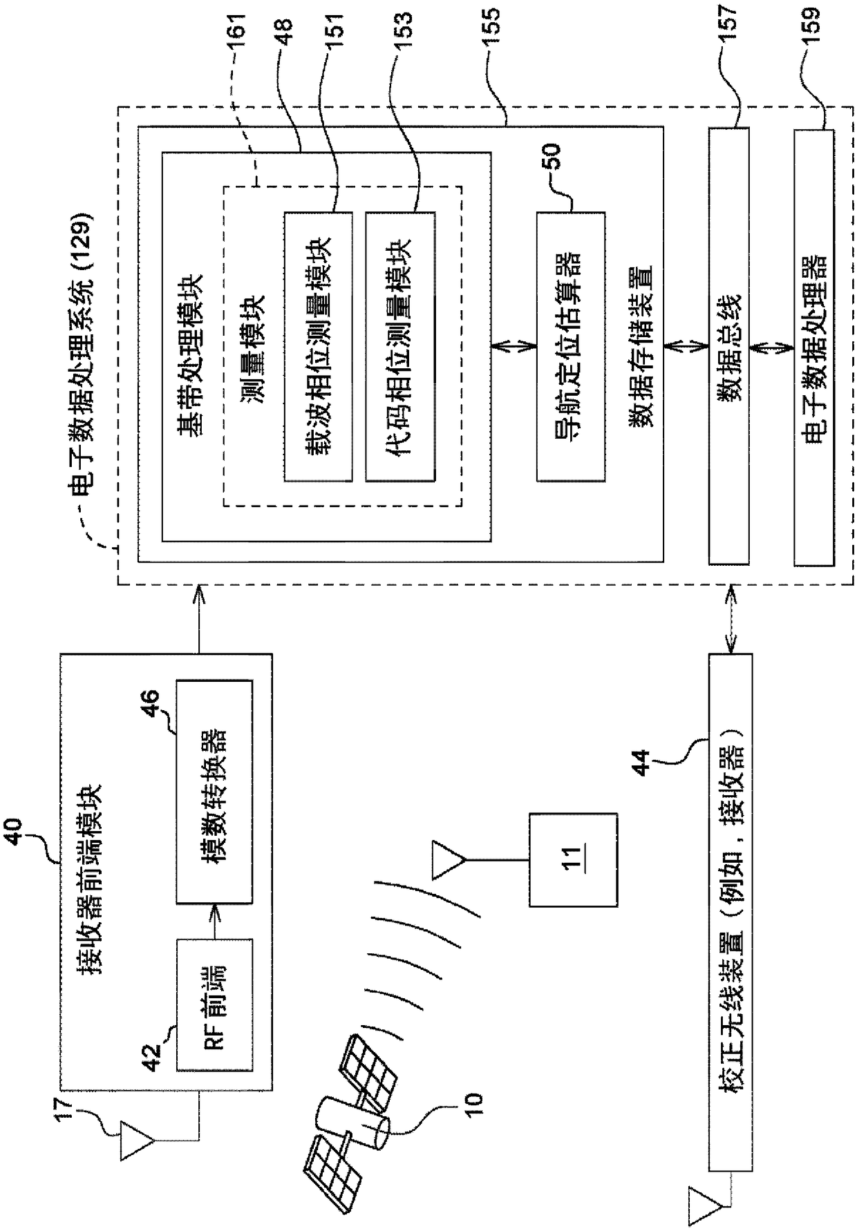
technical field [0001] This application generally relates to satellite navigation receivers with improved ambiguity resolution. In particular, the application relates to precise point positioning real-time kinematic (PPP-RTK) satellite navigation receivers and related methods for performing stable, robust and accurate integer ambiguity resolution with fast initialization. Background technique [0002] The Global Navigation Satellite System (GNSS) utilizes satellites to enable receivers to determine position, velocity and time with a very high degree of accuracy and precision using signals transmitted from the satellites. Such GNSS includes the Global Positioning System (GPS), the GLONASS Satellite Navigation System (GLONASS) and the Galileo Satellite Positioning System (Galileo). The signals transmitted from the satellites comprise one or more carrier signals transmitted at respective known frequencies, eg in GPS a first carrier (L1), a second carrier (L2) and an additional...

Claims


Application Information

Patent Timeline
Patent Type & Authority Applications(China)
IPC IPC(8): G01S19/00G01S19/38G01S19/39G01S19/40G01S19/42G01S19/43
CPCG01S19/37G01S19/33G01S19/44G01S19/32
Inventor 戴礼文迈克尔·A·塞特泽维
Owner DEERE & CO
Learn More