A dual-network-based aerial image difference detection method

An aerial image, difference detection technology, applied in biological neural network models, instruments, scene recognition and other directions, can solve problems such as difficulty in selecting effective feature descriptors, achieve the effect of easy expression, reduce requirements, and overcome high noise

Active Publication Date: 2021-06-11
NORTHWESTERN POLYTECHNICAL UNIV
View PDF5 Cites 0 Cited by
  • Summary
  • Abstract
  • Description
  • Claims
  • Application Information

AI Technical Summary

Problems solved by technology

The present invention adds deep learning to difference detection, since deep learning does not require manual design of features, it can avoid the problem of difficult selection of effective feature descriptors in image segmentation and difference detection

Method used


Image

  • A dual-network-based aerial image difference detection method
  • A dual-network-based aerial image difference detection method
  • A dual-network-based aerial image difference detection method

Examples


Embodiment Construction

[0074] Embodiments of the present invention are described in detail below, and the embodiments are exemplary and intended to explain the present invention, but should not be construed as limiting the present invention.

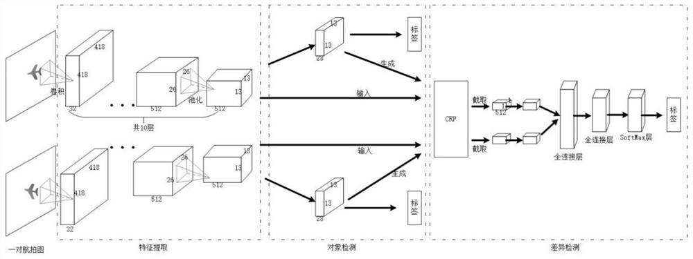
[0075] A kind of aerial image difference detection method based on double network in the present embodiment, comprises the following steps:

[0076] 1. Data collection and processing

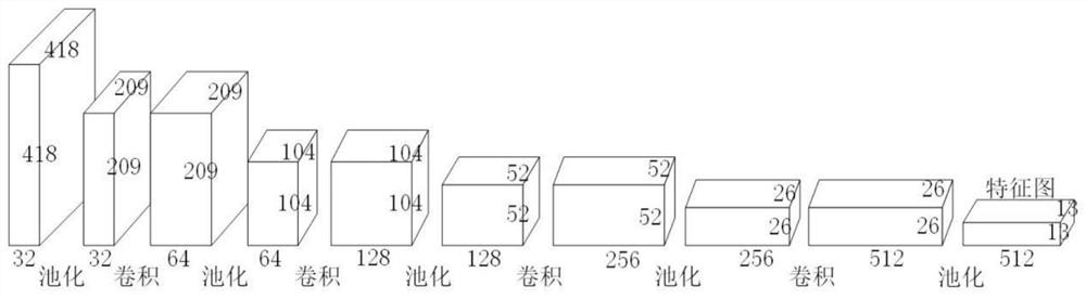
[0077] Neural networks are sensitive to the data they input, so in the field of deep learning, the processing of raw data is particularly important. Correctly processed data can not only speed up the convergence speed of network training, but also achieve better training results. The following introduces the data processing process in the present invention:

[0078] 1. Data collection

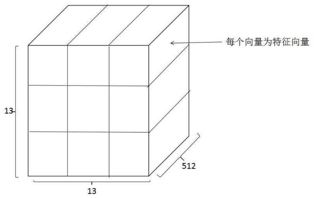
[0079] The drone flies along the same planned path at different times, and at the same time uses the drone's onboard camera to collect aerial pictures along the route. This results in a serie...


PUM


Abstract

The invention proposes a dual-network-based aerial image difference detection method, including image acquisition and processing, building a dual-network model, training the dual-network model and using the model. The present invention adds deep learning to the difference detection, since the deep learning does not need to manually design features, it can avoid the problem of difficult selection of effective feature descriptors in image segmentation and difference detection. The use of deep learning methods can also overcome the shortcomings of low robustness to illumination in the difference detection task of RGB images. At the same time, the present invention uses object detection to replace the traditional segmentation method, which can better distinguish individual objects, and the position coordinates of the objects are more accurate and easier to express. By calculating the ROI of the predicted frame after detection to determine the related objects of the two images, the requirements for registration accuracy can also be reduced. The important thing is that in the present invention, the semantic information of the object is added, and with the object category information, the anti-interference ability is stronger, and the difference type can be better analyzed.

Description

technical field [0001] The invention belongs to the field of image processing and machine vision, and relates to a method for detecting differences of aerial images based on double networks. Background technique [0002] In recent years, with the rapid development of drones, drone aerial photography has been widely used in fields such as agronomy, geology, forests, oceans, geographic surveying and mapping, military reconnaissance, and environmental protection. We measure the earth with unprecedented precision in terms of time and space, and collect various data quickly and accurately. In the past, data was acquired from the air, usually by using satellites or aircraft. But compared to these two, UAV is a superior "air sensor". The line of sight of satellites is blocked by clouds covering more than 2 / 3 of the earth, and drones can collect data more accurately and more frequently; compared with airplanes, drones are cheaper, easier to operate, and safer. UAVs can provide hi...

Claims


Application Information

Patent Timeline
Patent Type & Authority Patents(China)
IPC IPC(8): G06K9/00G06K9/32G06K9/62G06N3/04
CPCG06V20/13G06V10/25G06N3/045G06F18/214
Inventor 布树辉李清韩鹏程
Owner NORTHWESTERN POLYTECHNICAL UNIV
Why Eureka
Try Eureka