Multi-time-phase remote sensing inversion method of soybean biomass in black soil area by introducing topographic factor

A terrain factor and remote sensing inversion technology, which is applied to geographic information databases, instruments, character and pattern recognition, etc., can solve problems such as low accuracy and stability, single factor, difficult to apply statistical models and physical models, etc., to improve Accuracy and stability, solving the effect of space-time discontinuity

Inactive Publication Date: 2019-02-12
NORTHEAST AGRICULTURAL UNIVERSITY
View PDF4 Cites 6 Cited by
  • Summary
  • Abstract
  • Description
  • Claims
  • Application Information

AI Technical Summary

Problems solved by technology

[0003] Statistical models and physical models of traditional ground survey and monitoring are difficult to be practical, and there are certain difficulties and limitations in obtaining biomass no matter from the perspective of time or space; with the development of remote sensing technology, remote sensing data with higher spatial resolution can be accurately Capturing farmland soil and crop information can estimate biomass more quickly, accurately, efficiently and non-destructively
At present, the estimation model method based on traditional remote sensing vegetation index has single factors, low accuracy and stability, and cannot characterize the continuity of crop growth process, and it is difficult to meet the requirements of precise management at the field scale. Multi-temporal remote sensing inversion method is necessary

Method used


Image

  • Multi-time-phase remote sensing inversion method of soybean biomass in black soil area by introducing topographic factor
  • Multi-time-phase remote sensing inversion method of soybean biomass in black soil area by introducing topographic factor
  • Multi-time-phase remote sensing inversion method of soybean biomass in black soil area by introducing topographic factor

Examples


Embodiment Construction

[0026] The technical solutions in the embodiments of the present invention will be clearly and completely described below in conjunction with the accompanying drawings in the embodiments of the present invention. Obviously, the described embodiments are only some of the embodiments of the present invention, not all of them. Based on the embodiments of the present invention, all other embodiments obtained by persons of ordinary skill in the art without creative work all belong to the protection scope of the present invention.

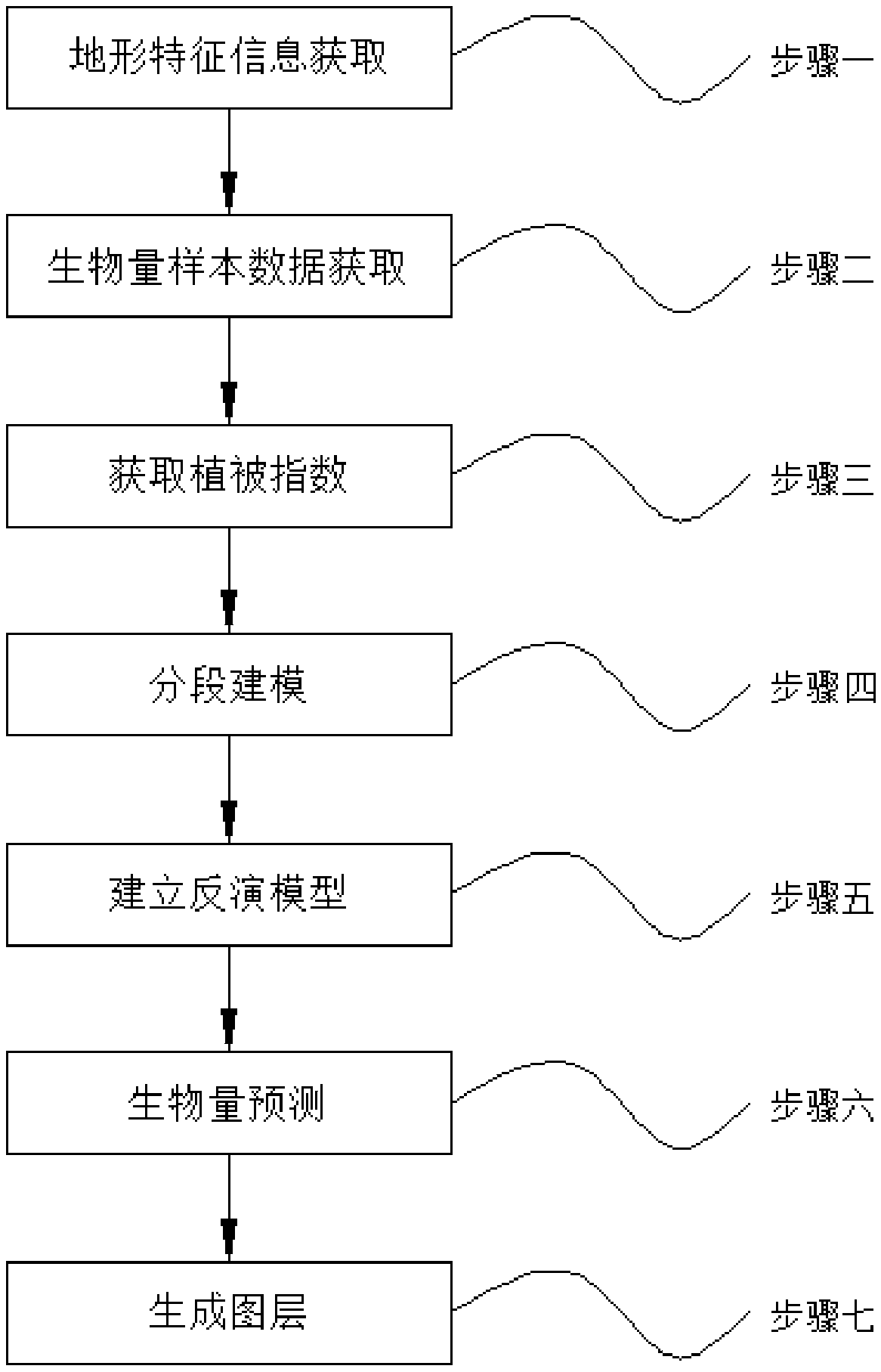
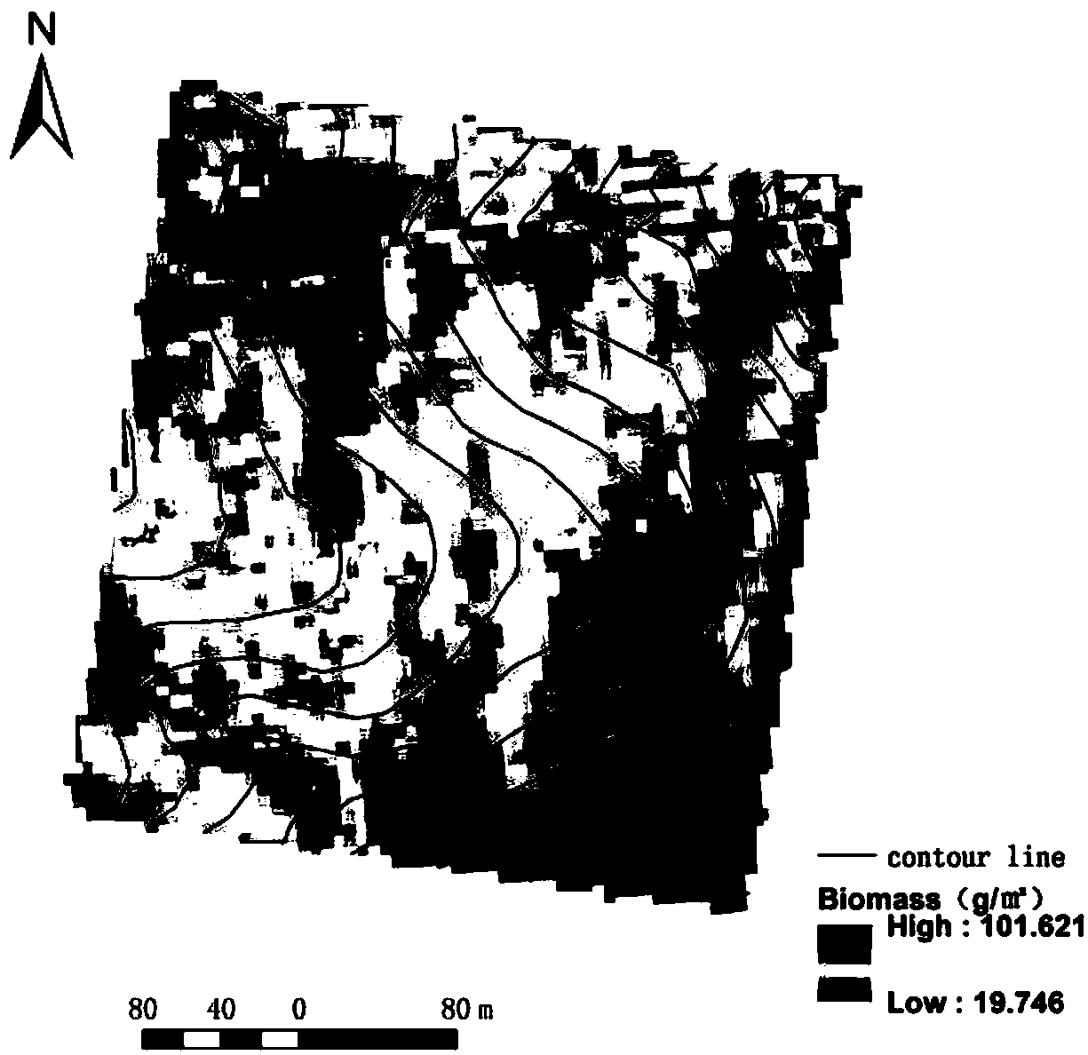
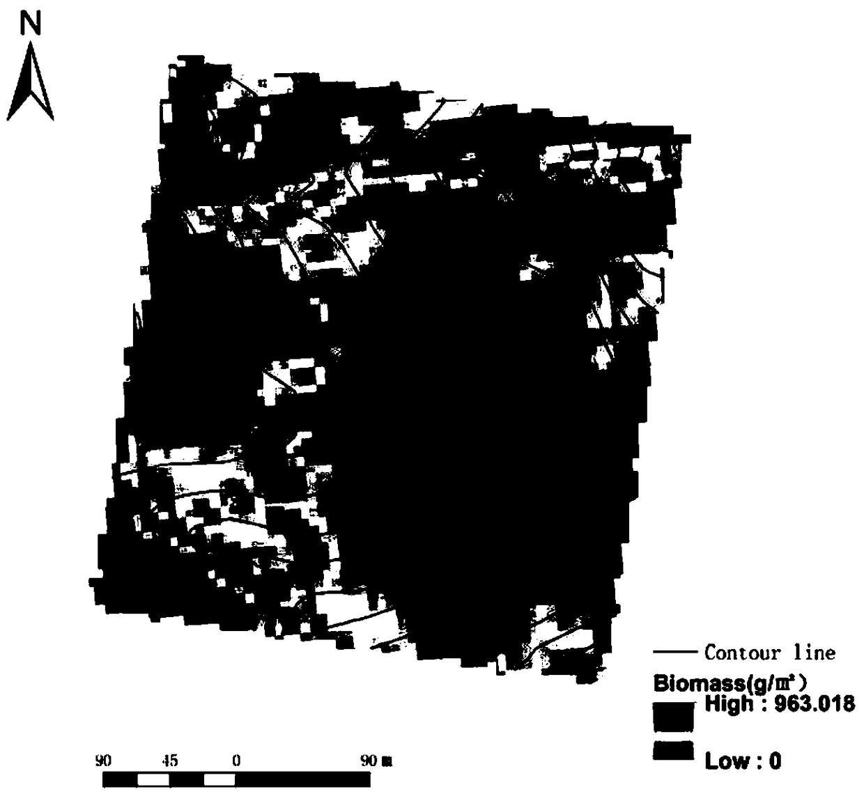
[0027] see Figure 1-4 , the present invention provides a technical solution:

[0028] The multi-temporal remote sensing inversion method of soybean biomass in black soil area with the introduction of terrain factors includes the following steps: Step 1, acquisition of terrain feature information; Step 2, acquisition of biomass sample data; Step 3, acquisition of vegetation index; Step 4, segmented modeling; Step 5, build an inversion model; Step 6, bio...


PUM


Abstract

The invention discloses a multi-time-phase remote sensing inversion method of the soybean biomass in a black soil area by introducing a topographic factor. The method comprises the following steps of1 acquiring the topographic characteristic information; 2 acquiring biomass sample data; 3 obtaining a vegetation index; 4 segmenting modeling; 5,establishing an inversion model; 6 predicting the biomass; 7 generating a map layer. In the step 1, the high-precision DEM data of the land block in the bare soil period is measured on the spot, and the starfish iRTK2 with the positioning accuracy of centimeters is used for the field survey of the land block in the study area, The method of the invention innovatively adds the topographic correlation factors on the basis of the traditional vegetationindex, which not only improves the accuracy and stability of the traditional model, but also can inversely estimate the crop growth for multiple periods, and at the same time, solves the problems of low precision and low stability of vegetation index model, and also solves the problem of temporal and spatial discontinuity of biomass inversion.

Description

technical field [0001] The invention relates to the technical field of multi-period precise inversion and monitoring of soybean biomass, in particular to a method for multi-temporal remote sensing inversion of soybean biomass in black soil areas by introducing terrain factors. Background technique [0002] Biomass is an important indicator for crop growth monitoring. Biomass per unit area reflects the growth of crop groups and is the basis for crop yield estimation. Biomass estimation is an important part of serving modern agriculture. Timely and accurate biomass simulation provides technical support for precise management of field-scale crops, and is of great significance to national agricultural decision-making, farmland production management, and grain storage security. [0003] Statistical models and physical models of traditional ground survey and monitoring are difficult to be practical, and there are certain difficulties and limitations in obtaining biomass no matter ...

Claims


Application Information

Patent Timeline
Patent Type & Authority Applications(China)
IPC IPC(8): G06K9/00G06K9/36G06F16/29
CPCG06V20/188G06V10/247G06V10/20
Inventor 张新乐徐梦园刘焕军潘越杨昊轩鲍依临
Owner NORTHEAST AGRICULTURAL UNIVERSITY
Why Eureka
Try Eureka