Multimode receiver joint location solution method

A joint positioning and receiver technology, applied in the field of global satellite navigation systems, can solve problems such as difficult engineering implementation and heavy computation

Inactive Publication Date: 2019-03-01
北极星云空间技术股份有限公司
View PDF6 Cites 13 Cited by
  • Summary
  • Abstract
  • Description
  • Claims
  • Application Information

AI Technical Summary

Problems solved by technology

When the number of satellites is n, the inverse matrix dimension n x n is required. At present, the number of satellites that can be tracked by the four major systems at the same time is as many as 40, so the implementation on the embedded system will bring a very heavy calculation load, and the engineering implementation is very difficult.

Method used


Image

  • Multimode receiver joint location solution method
  • Multimode receiver joint location solution method
  • Multimode receiver joint location solution method

Examples


Embodiment Construction

[0072] In the following description, numerous specific details are given in order to provide a more thorough understanding of the present invention. It will be apparent, however, to one skilled in the art that the present invention may be practiced without one or more of these details. In other examples, some technical features known in the art are not described in order to avoid confusion with the present invention.

[0073] In order to thoroughly understand the present invention, detailed steps and detailed structures will be provided in the following description, so as to illustrate the technical solution of the present invention. Preferred embodiments of the present invention are described in detail below, however, the present invention may have other embodiments besides these detailed descriptions.

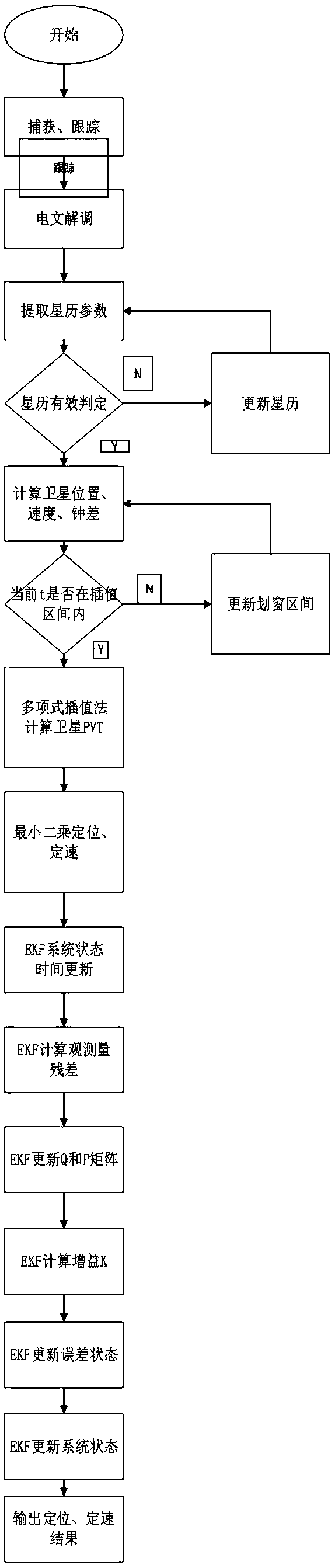
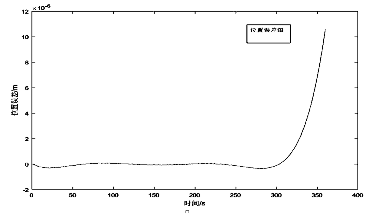
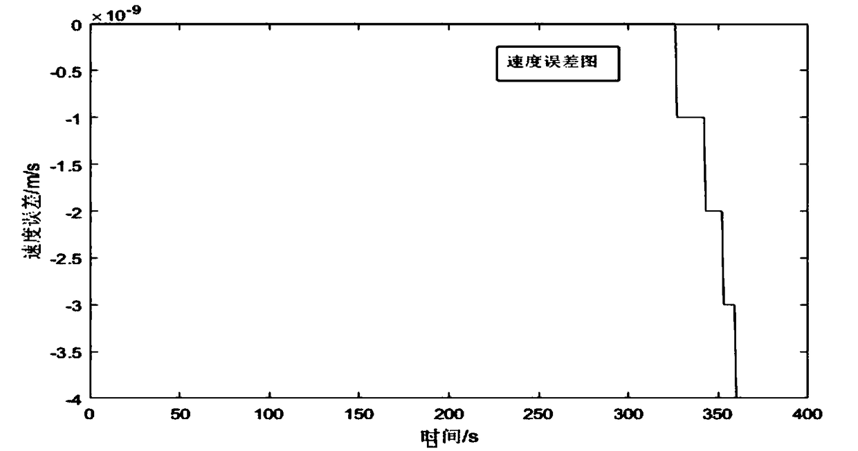
[0074] refer to Figure 1-Figure 2c As shown, a method for multi-mode receiver joint positioning solution provided by the present invention, the method includes the followi...


PUM


Abstract

The present invention provides a multimode receiver joint location solution method. The method comprises the following steps of: the step (1): calculating positions, speeds and clock corrections of six moments of a satellite by an ephemeris; the step (2): calculating a coefficient matrix A; the step (3): performing interpolation calculation of the position, the speed and the clock correction of the satellite at a t moment; the step (4): performing least squares localization solution; and the step (5): performing Kalman filtering solution. The method employs the satellite ephemeris parameters to calculate a satellite space position coordinate boundary value, in a sliding time interval, a polynomial fitting interpolation algorithm is employed to perform satellite orbit estimation to reduce the operation complexity of the satellite space position, the mode of combination of the least squares and the Kalman filtering is employed to perform receiver location solution, the Kalman filtering employs a serial update method to avoid the large-dimensionality matrix inversion operation and reduce the operation complexity so as to provide the high-frequency location result and meet the high-dynamic scene application.

Description

technical field [0001] The invention relates to the field of Global Navigation Satellite System (GNSS), in particular to a method for joint positioning and calculation of multi-mode receivers. Background technique [0002] At present, the global satellite navigation system (GNSS) mainly includes China's BDS, the United States' GPS, Russia's GLONASS, and Europe's Galileo. GNSS plays an extremely important role in both military and civilian fields. In military applications, it can improve the target hit rate of missiles; in the civilian field, GNSS can locate and navigate objects at all levels of sea, land, and air, including Ocean-going navigation and water diversion for ships, autonomous navigation for cars, route guidance for aircraft, approach and landing, etc. In addition, the core technology of various ground vehicle tracking and urban intelligent traffic management is GNSS positioning; it can also provide timing and frequency calibration for network systems such as ele...

Claims


Application Information

Patent Timeline
Patent Type & Authority Applications(China)
IPC IPC(8): G01S19/42G01S19/44
CPCG01S19/425G01S19/44
Inventor 张雪松杨华李斌侯启东张莲
Owner 北极星云空间技术股份有限公司
Why Eureka
Try Eureka