A remote sensing monitoring method for the whole process of land reclamation and reclamation area development

A technology of land reclamation and remote sensing monitoring, applied in the field of surveying and mapping engineering, can solve the problems of not reflecting the development time sequence process of the reclamation area, unfavorable to the refined management of the reclamation area, etc., to achieve intensive and efficient use of marine space resources and improve management. efficacy effect

Active Publication Date: 2019-03-08
NATIONAL MARINE ENVIRONMENTAL MONITORING CENTRE
View PDF3 Cites 4 Cited by
  • Summary
  • Abstract
  • Description
  • Claims
  • Application Information

AI Technical Summary

Problems solved by technology

However, the current reclamation monitoring only uses remote sensing images to simply monitor the distribution area and occupied sea area of ​​re...

Method used


Image

  • A remote sensing monitoring method for the whole process of land reclamation and reclamation area development
  • A remote sensing monitoring method for the whole process of land reclamation and reclamation area development
  • A remote sensing monitoring method for the whole process of land reclamation and reclamation area development

Examples


Embodiment Construction

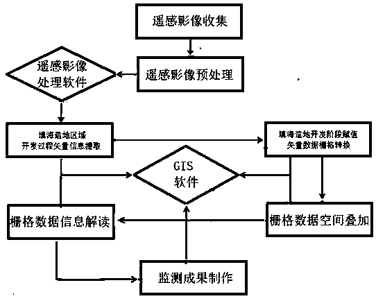
[0012] figure 1 A process flow of remote sensing monitoring in the whole process of development of land reclamation area is shown. It includes remote sensing image collection, remote sensing image preprocessing, extraction of vector information in the development process of reclamation and land reclamation, assignment of reclamation and development stage and conversion of vector data to raster, spatial overlay of raster data, interpretation of raster data information after spatial overlay, There are 7 process links in the production of monitoring results.

[0013] (1) Remote sensing image collection: try to collect remote sensing images with a spatial resolution better than 5m collected at the same period of each year (at least the same quarter).

[0014] (2) Remote sensing image preprocessing: It mainly includes geometric fine-tuning and image resampling. Geometric fine correction needs to collect at least 16 precise control points of ground measurement geographic location ...


PUM


Abstract

A remote sensing monitoring method for the whole process of land reclamation and reclamation area development belongs to the surveying and mapping engineering field. In this technology, the remote sensing images and the actual land reclamation area are used to construct the remote sensing image characteristic database of land reclamation increment period, settlement period, stock period and salesperiod, and then the remote sensing image database is used to classify and extract the land reclamation area in each remote sensing image sequence. The land reclamation regions extracted from each phase of remote sensing images are classified and assigned values, and then converted into grid format for spatial superposition. According to the spatial superposition of grid numerical, the whole process of land reclamation and development of each grid unit is analyzed, a remote sensing monitoring result map of the whole process of land reclamation and regional development is made, and the space-time holographic process of the land reclamation and regional development is analyzed and gathered. The monitoring method accurately monitors the holographic process of land reclamation, improves the management efficiency of marine natural resources, and achieves the purpose of intensive and efficient use of marine spatial resources.

Description

technical field [0001] The invention relates to a remote sensing monitoring method for the whole process of developing a land reclamation area, which belongs to the field of surveying and mapping engineering. It mainly uses high spatial resolution remote sensing images to carry out continuous monitoring of the reclamation area, and through the spatial overlay of the monitoring results, it is a remote sensing monitoring engineering technology that reflects the temporal and spatial holographic process of the development of the reclamation area. Background technique [0002] Land reclamation is the human marine development and utilization activity that reclaims the ocean to form land for social and economic development. In recent years, with the rapid social and economic development in developed coastal areas, there are more people and less land, and land resources are increasingly scarce, and the development space is severely limited. In order to expand the development space,...

Claims


Application Information

Patent Timeline
IPC IPC(8): G06K9/00G06K9/62
CPCG06V20/182G06F18/24
Inventor 索安宁初佳兰李飞卫宝泉宋德瑞赵建华
Owner NATIONAL MARINE ENVIRONMENTAL MONITORING CENTRE
Why Eureka
Try Eureka