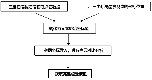
A method for three-dimensional comparison between spatial coordinate points and point cloud points
A technology of spatial coordinates and 3D comparison, applied in image data processing, instruments, 3D modeling, etc., can solve the problem of lack of local 3D reconstruction effect, and achieve the effect of small external influence, high precision and high flexibility
- Summary
- Abstract
- Description
- Claims
- Application Information
AI Technical Summary
Problems solved by technology
Method used
Image
Examples
Embodiment 1
[0026] 1. For 3D scanning, it is first necessary to ensure that the 3D scanner is built in a stable environment (including light environment: avoid strong light and backlighting; the stability of the 3D scanner, etc.), to ensure that the 3D scanning results will not be affected by external factors. Impact. Calibrating the machine is a particularly critical step before 3D scanning. During the calibration process, the position of the scanning device relative to the scanned object should be calculated according to the preset scanning mode of the 3D scanner. Some object surfaces are more difficult to scan. For these objects, it is necessary to use a matte white imaging agent to cover the surface of the scanned object, and spray a thin layer of imaging agent on the scanned object. The purpose is to better scan the three-dimensional features of the object, and the data will be more accurate. Use the 3D scanner to capture the 3D data of the scanned object from different angles, cha...
PUM
 Abstract
Description
Claims
Application Information
 - R&D
- Intellectual Property
- Life Sciences
- Materials
- Tech Scout
- Unparalleled Data Quality
- Higher Quality Content
- 60% Fewer Hallucinations
Browse by: Latest US Patents, China's latest patents, Technical Efficacy Thesaurus, Application Domain, Technology Topic, Popular Technical Reports.
© 2025 PatSnap. All rights reserved.Legal|Privacy policy|Modern Slavery Act Transparency Statement|Sitemap|About US| Contact US: help@patsnap.com

