Mountain fire monitoring and early warning method for transmission lines based on geostationary satellite monitoring data

A technology of transmission lines and monitoring data, which is applied to forest fire alarms, fire alarms that rely on radiation, and fire alarms. It can solve problems such as tourist mistakes, lax supervision, and threats to the safe and stable operation of the power grid. To achieve the effect of improving accuracy and improving precision

Active Publication Date: 2020-06-30
BEIJING E TECHSTAR
View PDF6 Cites 0 Cited by
  • Summary
  • Abstract
  • Description
  • Claims
  • Application Information

AI Technical Summary

Problems solved by technology

[0002] In recent years, with global warming and frequent extreme weather, the inland areas of our country have more and more hot and sunny weather in spring and autumn; at the same time, as a large agricultural country, our country has a tradition of burning straw and other agricultural waste since ancient times; Although our country strictly prohibits tourists from carrying any fire source when traveling up the mountain, but in some inaccessible areas, the supervision will be lax, and some tourists’ mistakes will lead to mountain fires
With the implementation of the policy of returning farmland to forests in our country, the protection of vegetation in mountainous areas is getting better and better. Once a wildfire occurs, it will spread rapidly. If it cannot be extinguished in time, it will cause the transmission line to trip due to the wildfire, which seriously threatens the safe and stable operation of the power grid.

Method used


Image

  • Mountain fire monitoring and early warning method for transmission lines based on geostationary satellite monitoring data
  • Mountain fire monitoring and early warning method for transmission lines based on geostationary satellite monitoring data
  • Mountain fire monitoring and early warning method for transmission lines based on geostationary satellite monitoring data

Examples


Embodiment Construction

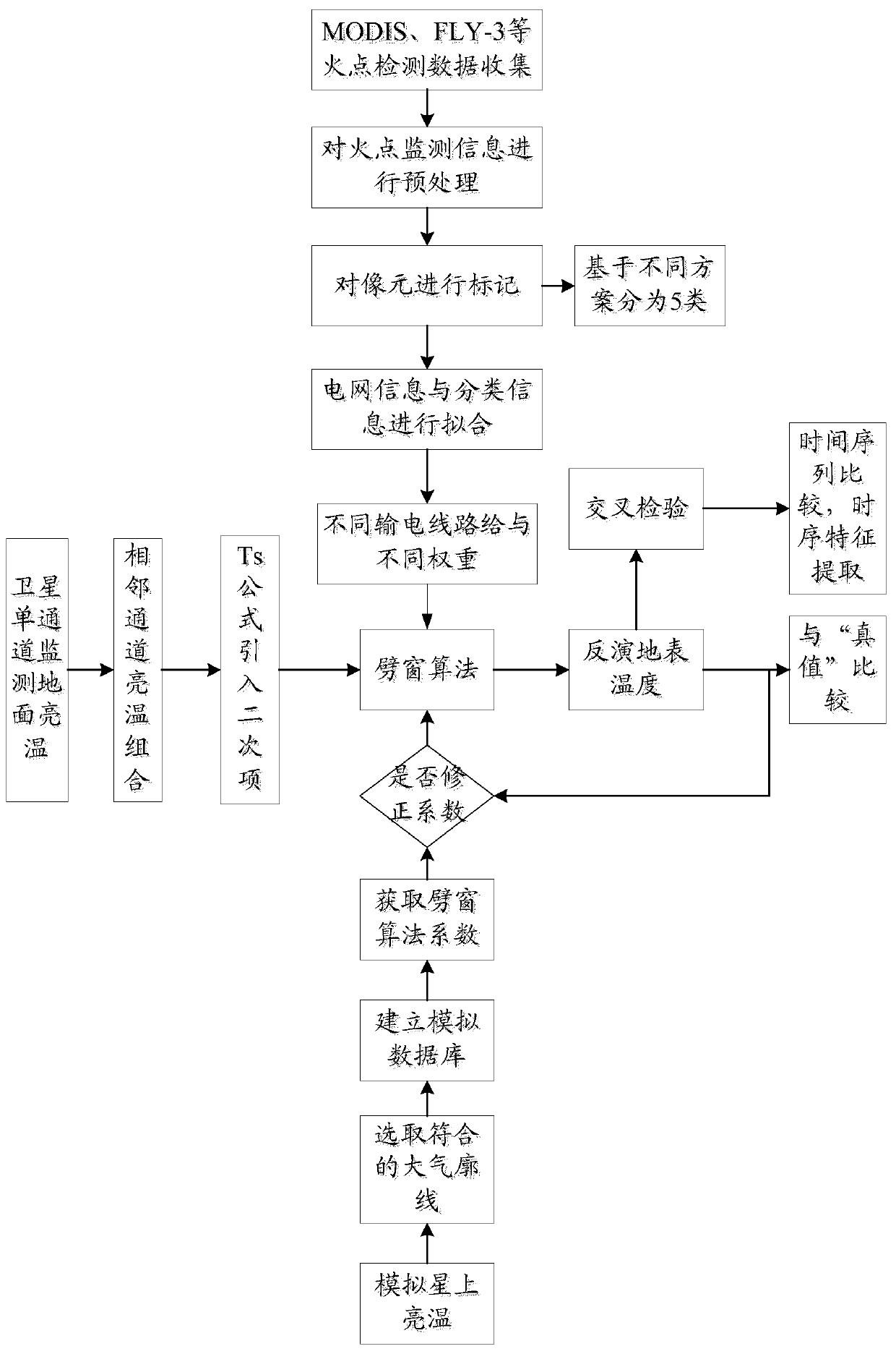
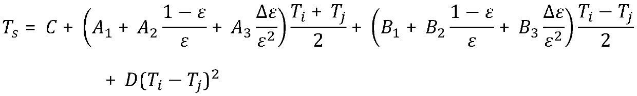
[0037] In order to make the technical problems, technical solutions and beneficial effects solved by the present invention clearer, the present invention will be further described in detail below in conjunction with the accompanying drawings and embodiments. It should be understood that the specific embodiments described here are only used to explain the present invention, not to limit the present invention.

[0038] The transmission lines of the power sector are mainly in the wild, and wildfires erupt very quickly. Therefore, the data calculation speed and transmission speed in fire point monitoring will affect the final loss of transmission lines and the speed of wildfire extinguishment. For the power sector, the traditional fire point monitoring method mainly has four shortcomings: 1. Due to the different work units, the meteorological department and the power department cannot carry out in-depth cooperation. Often the meteorological department detects the fire point, but it...


PUM


Abstract

The invention provides a power transmission line vegetation fire monitoring and early warning method based on geostationary satellite monitoring data. The method includes the steps that land cover types corresponding to the pixels of a landform picture are determined, and the weights of power transmission line units are calculated; the atmospheric profile of a monitoring area during monitoring isdetermined in real time; ground brightness temperature values measured by satellites in adjacent channels respectively are determined; inverse surface temperatures corresponding to the pixels are calculated; after being obtained, the inverse surface temperatures corresponding to the pixels are marked on the landform picture, centralized analysis of the distribution of the inverse surface temperatures on the landform picture is conducted, and then vegetation fire monitoring and early warning are conducted. The power transmission line vegetation fire monitoring and early warning method based onthe geostationary satellite monitoring data has the advantages that the precision of the inverse surface temperatures can be improved, and thus the accuracy of vegetation fire monitoring and early warning can be effectively improved when vegetation fire monitoring and early warning are conducted according to the inverse surface temperatures.

Description

technical field [0001] The invention belongs to the technical field of mountain fire monitoring and early warning, and in particular relates to a method for monitoring and early warning of mountain fires in power transmission lines based on static satellite monitoring data. Background technique [0002] In recent years, with global warming and frequent extreme weather, the inland areas of our country have more and more hot and sunny weather in spring and autumn; at the same time, as a large agricultural country, our country has a tradition of burning straw and other agricultural waste since ancient times; Although our country strictly prohibits tourists from carrying any fire source when traveling up the mountain, the supervision will be lax in some inaccessible areas, and some tourists' mistakes will cause mountain fires. With the implementation of the policy of returning farmland to forests in my country, the protection of vegetation in mountainous areas is getting better ...

Claims


Application Information

Patent Timeline
Patent Type & Authority Patents(China)
IPC IPC(8): G08B17/00G08B17/12
CPCG08B17/005G08B17/125
Inventor 钱苏晋杨馨李飞张悦
Owner BEIJING E TECHSTAR
Why Eureka
Try Eureka