Integrated space and terrestrial information based stereoscopic monitoring method for air pollution and monitoring system

A monitoring system and air pollutant technology, applied in the field of three-dimensional air pollution monitoring method and monitoring system of space-ground integration, can solve the problems of low distance resolution and time resolution accuracy

Inactive Publication Date: 2019-03-29
天津珞雍空间信息研究院有限公司
View PDF5 Cites 13 Cited by
  • Summary
  • Abstract
  • Description
  • Claims
  • Application Information

AI Technical Summary

Problems solved by technology

[0005] The present invention aims at the technical defects of the prior art, and provides a space-ground integrated air pollution three-dimensional monitoring method and monitorin

Method used


Image

  • Integrated space and terrestrial information based stereoscopic monitoring method for air pollution and monitoring system
  • Integrated space and terrestrial information based stereoscopic monitoring method for air pollution and monitoring system

Examples


Embodiment 1

[0044] A space-ground integrated three-dimensional monitoring method for air pollution, such as figure 2 shown, including:

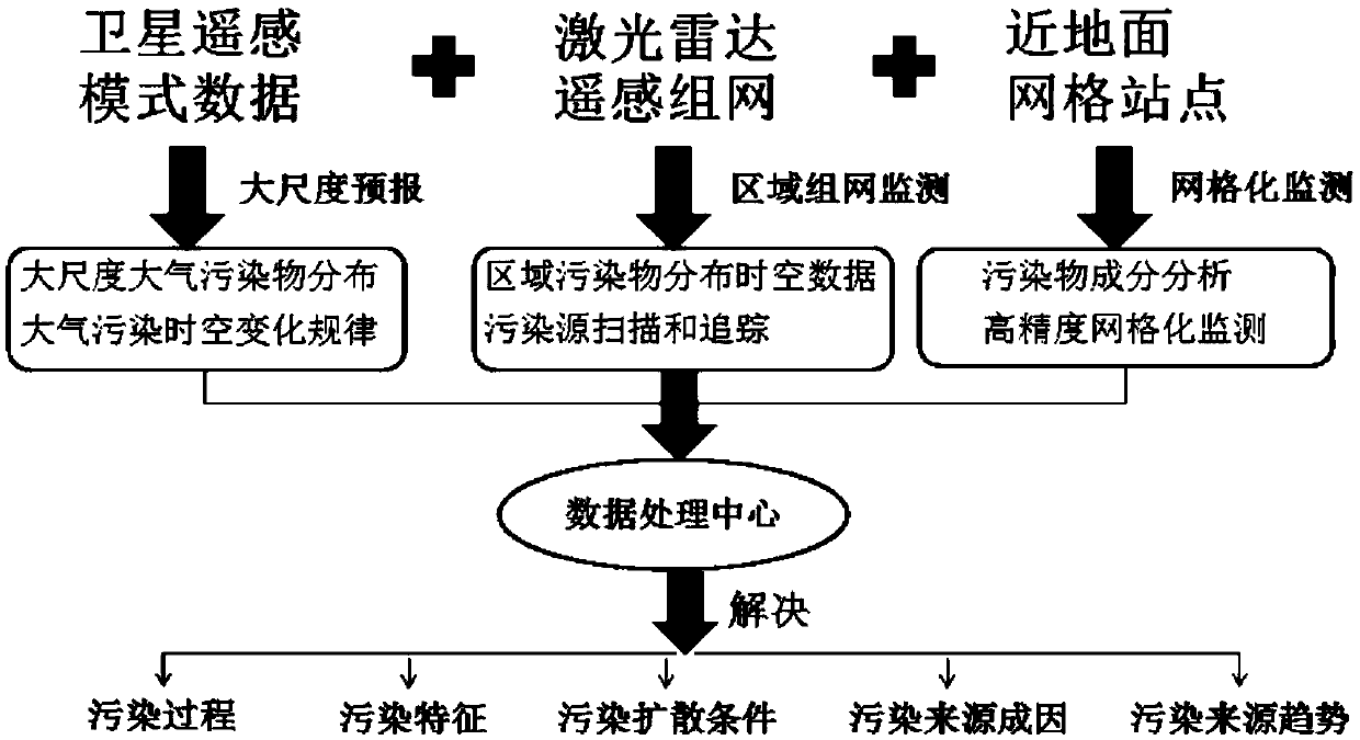
[0045] Satellite remote sensing technology is used to monitor the distribution of atmospheric pollutants and the overall diffusion trend on a large scale in the region, and to preliminarily determine local and external sources;

[0046] LiDAR network monitoring adopts two observation modes: horizontal / vertical, among which:

[0047] The horizontal observation mode is used to draw the distribution of mesoscale atmospheric aerosols centered on the observation point (reflecting the distribution of PM2.5 and PM10), find the location of important pollution sources according to the distribution map, compile a map of pollution sources in the monitoring area, and further conduct network analysis. Grid precision detection.

[0048] The vertical observation mode is used to draw the vertical structure of pollutants, supplemented by the backward trajectory model,...

Embodiment 2

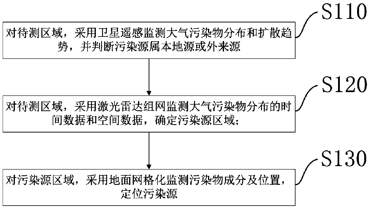
[0052] A space-ground integrated three-dimensional monitoring method for air pollution, such as figure 1 shown, including:

[0053] S110: Use satellite remote sensing to monitor the distribution and diffusion trend of atmospheric pollutants in the area to be measured, and determine whether the pollution source is local or external;

[0054] S120: In the area to be measured, use the laser radar network to monitor the time data and spatial data of the distribution of air pollutants, and determine the pollution source area;

[0055] S130: For the pollution source area, use the ground grid to monitor the composition and location of the pollutants, and locate the pollution source.

[0056] A monitoring system based on the above method, comprising:

[0057] Satellite remote sensing monitoring unit: used in the area to be measured, using satellite remote sensing to monitor the distribution and diffusion trend of atmospheric pollutants, and to determine whether the pollution source ...

Embodiment 3

[0061] A space-ground integrated three-dimensional monitoring method for air pollution, comprising:

[0062] In the area to be measured, use satellite remote sensing to monitor the distribution and diffusion trend of atmospheric pollutants, and determine whether the pollution source is local or external;

[0063] In the area to be measured, the laser radar network is used to monitor the time data and spatial data of the distribution of air pollutants to determine the pollution source area;

[0064] For the pollution source area, use the ground grid to monitor the composition and location of pollutants, and locate the pollution source.

[0065] Among them, in the process of lidar network monitoring, horizontal observation mode and vertical observation mode are adopted. The horizontal observation mode is used to draw the distribution of atmospheric aerosols centered on the observation point in the horizontal plane, find the location of the pollution source area according to the...


PUM


Abstract

The invention discloses an integrated space and terrestrial information based stereoscopic monitoring method for air pollution and a monitoring system. The method comprises the following steps: establishing satellite remote sensing and atmospheric model monitoring to monitor the distribution and diffusion trends of large-scale dyes in a region to initially determine local and external sources; establishing a laser radar network monitoring system to locate and track air pollution sources at the same time; and establishing a densely distributed ground monitoring grid site for accurate analysis of the causes of atmospheric pollution sources. Through the three-level monitoring system, the detection of air pollution in the monitoring area can be completed, and serious areas of air pollution, sources of pollutants, and the distribution and diffusion situation of key pollution sources can be clarified. And then the processing, statistics, and analysis of massive data can be completed based ona software platform to obtain monitoring results. The invention can realize effective monitoring of atmospheric pollutants, which has high distance resolution and time resolution.

Description

technical field [0001] The invention relates to the technical field of air pollution environment monitoring, in particular to a space-ground integrated three-dimensional air pollution monitoring method and monitoring system. Background technique [0002] With the acceleration of industrialization and urbanization, my country's environmental problems have become increasingly prominent, and smog problems of varying degrees have appeared across the country. Air pollution has seriously restricted social development and the ecological environment. [0003] In this situation, environmental monitoring for air pollution is particularly important. Atmospheric environmental monitoring is the measurement process of observing and analyzing the concentration of pollutants in the atmospheric environment and its impact on the environment, so as to clarify the types and concentrations of pollutants in the atmosphere, and observe their temporal and spatial distribution and change rules. Mo...

Claims


Application Information

Patent Timeline
IPC IPC(8): G01S17/88G01N15/06
CPCG01N15/06G01N2015/0693G01S17/88
Inventor 马昕龚威王成义史硕徐宝张玲玲
Owner 天津珞雍空间信息研究院有限公司
Why Eureka
Try Eureka