Unlock instant, AI-driven research and patent intelligence for your innovation.

Geographical coordinate compression coding and decoding method based on three-dimensional space partition

An encoding and decoding method and a technology of geographic coordinates, applied in the field of 3D model simplification, can solve problems such as large data volume, uncertainty, and mathematical constraint failure, and achieve the effect of reducing data volume and ensuring scalability.

Active Publication Date: 2019-03-29
SUZHOU IND PARK SURVEYING MAPPING & GEOINFORMATION CO LTD
View PDF10 Cites 4 Cited by
  • Summary
  • Abstract
  • Description
  • Claims
  • Application Information

AI Technical Summary

Problems solved by technology

These methods generally have two problems: first, the simplification method is oriented to the 3D model itself, and a single complex 3D model is still a single relatively complex 3D model after simplification, which cannot be divided into smaller data units; secondly, The distribution of errors caused by simplification in three-dimensional geographic space has great uncertainty, and it is impossible to predict where large errors will occur in the three-dimensional model and the range of these errors
[0004] Therefore, in the current 3D model data simplification method for 3D electronic maps, some simplified 3D model individuals of geographical elements, such as terrain models, still have a large amount of data, and the error uncertainty caused by simplification leads to map The strict mathematical constraints represented by the scale fail, and it is impossible to achieve precise and controllable spatial measurement in the 3D electronic map, which brings difficulties to the application of the 3D electronic map

Method used


Image

  • Geographical coordinate compression coding and decoding method based on three-dimensional space partition
  • Geographical coordinate compression coding and decoding method based on three-dimensional space partition
  • Geographical coordinate compression coding and decoding method based on three-dimensional space partition

Examples


Embodiment Construction

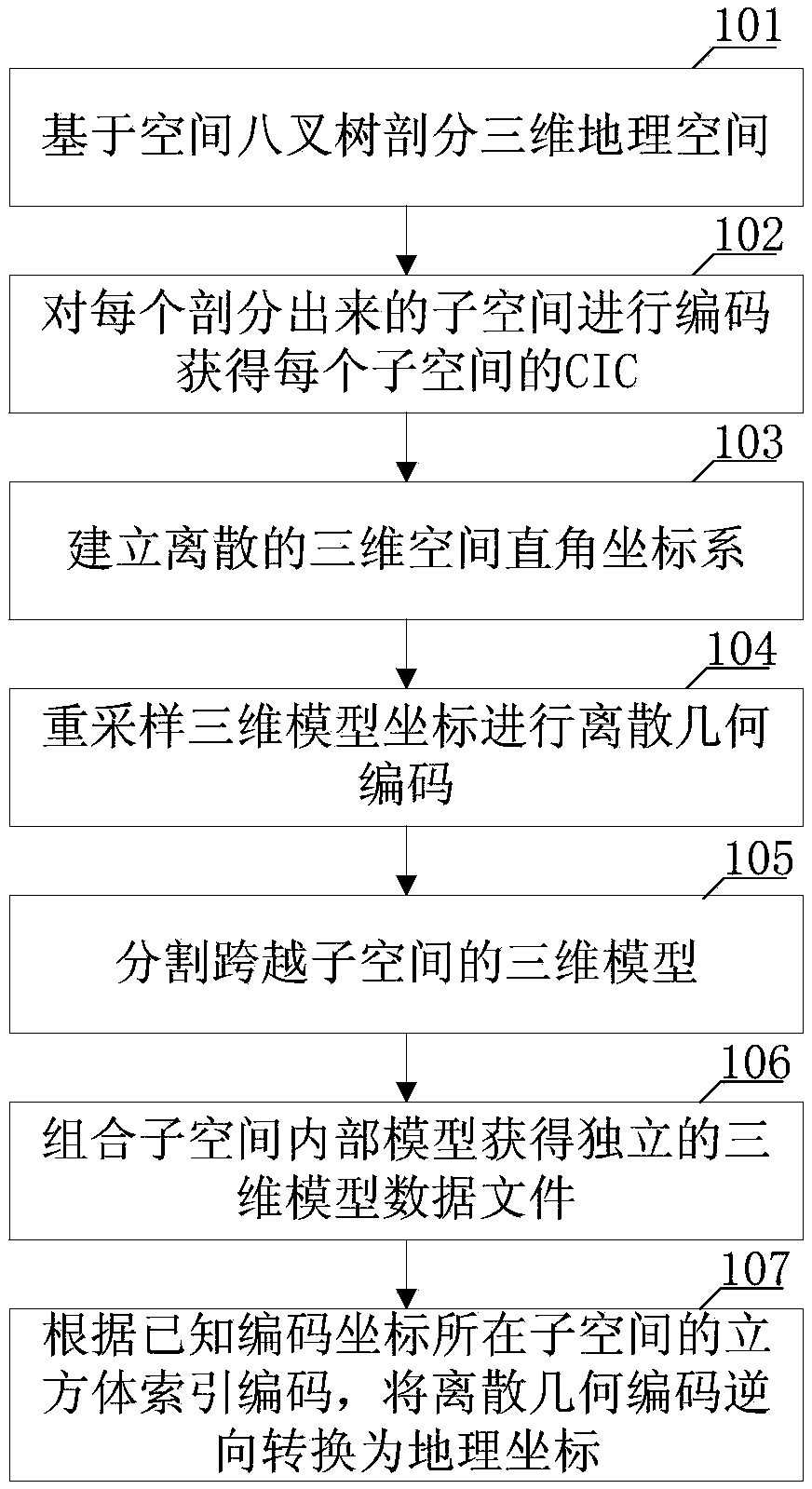
[0042] Such as figure 1 Shown, in some demonstrative embodiments, provide a kind of geographical coordinate compression codec method based on three-dimensional space subdivision, comprise three parts: the first, the cube index code (CIC, CubeIndex) based on spatial octree division Code) process; second, the process of 3D model resampling and discrete geometry encoding; third, the decoding process of inverse conversion of discrete geometry encoding into geographic coordinates. Realize the compression of the three-dimensional model data in the three-dimensional electronic diagram, and realize the model simplification and model individual segmentation of the three-dimensional model data under the constraints of different scales.

[0043] The geographic coordinate compression encoding and decoding method based on three-dimensional space subdivision of the present invention includes:

[0044] 101: Based on the octree algorithm, set the subdivision depth, and recursively subdivide ...


PUM


Abstract

The invention provides a geographic coordinate compression encoding and decoding method based on three-dimensional space partition, which comprises the following steps: a cube index encoding process based on spatial octree partition; 3-D model resampling and discrete geometric coding; discrete geometric coding is a decoding process in which geographic coordinates are converted into geographic coordinates by inverse transformation. two strict mathematical constraints are guaranteed in the process of cube index coding. the geographic coordinates are converted from large floating-point value to integer data in [0, 512], which compresses the storage space of coordinates, so the model simplification and model individual segmentation of 3D model data under different scale constraints are realized. the amount of data of single model file is reduced, and subspaces with different division precision in the same geographic space range can be found through CIC, so that the encoded three-dimensional model can support progressive network transmission; The decoded coordinates will not invalidate the mathematical constraint represented by the map scale, which ensures the scalability of the three-dimensional map at all scales.

Description

technical field [0001] The invention belongs to the technical field of three-dimensional model simplification, and in particular relates to a geographic coordinate compression encoding and decoding method based on three-dimensional space subdivision. Background technique [0002] In the existing 3D electronic map technology, the 3D model data directly records the 3D spatial geographic coordinates of all the feature points of the object. With the continuous enrichment of urban 3D models and the continuous expansion of the geographical scope of electronic maps, the data volume of 3D models in 3D electronic maps is increasing exponentially, which makes it more and more difficult to improve the efficiency of data transmission, loading and display rendering. . [0003] In order to solve the above technical problems, when 3D electronic maps display large-scale geographical scenes or high-precision urban models, the method of 3D model simplification is usually adopted to reduce th...

Claims


Application Information

Patent Timeline
IPC IPC(8): G06T9/00
CPCG06T9/00
Inventor 蒋如乔钱程扬张琪李目贤丁浩
Owner SUZHOU IND PARK SURVEYING MAPPING & GEOINFORMATION CO LTD
Features
  • R&D
  • Intellectual Property
  • Life Sciences
  • Materials
  • Tech Scout
  • Unparalleled Data Quality
  • Higher Quality Content
  • 60% Fewer Hallucinations
Learn More