Path surveying and calibrating method and system using unmanned ship, and unmanned ship

A calibration method and unmanned ship technology, applied in surveying and navigation, measuring devices, open-air water source surveying, etc., can solve problems such as missing blank areas, increasing surveying and mapping workload, and lack of real-time monitoring of on-board personnel, so as to improve accuracy and reliability effect

Inactive Publication Date: 2019-04-12
EAST CHINA NORMAL UNIV +1
View PDF3 Cites 10 Cited by
  • Summary
  • Abstract
  • Description
  • Claims
  • Application Information

AI Technical Summary

Problems solved by technology

However, due to the lack of real-time monitoring of the crew on board and manual adjustment of the direction of the ship, if the unmanned ship still relies on the traditional planning survey line, if the measurement and calibration of the area with obvious fluctuations in the seabed is not carried out, blank areas may be missed. It is necessary to make supplementary measurements on the missing blank areas, which increases a lot of surveying and mapping workload

Method used


Image

  • Path surveying and calibrating method and system using unmanned ship, and unmanned ship
  • Path surveying and calibrating method and system using unmanned ship, and unmanned ship
  • Path surveying and calibrating method and system using unmanned ship, and unmanned ship

Examples


Embodiment Construction

[0039] The following will clearly and completely describe the technical solutions in the embodiments of the present invention with reference to the accompanying drawings in the embodiments of the present invention. Obviously, the described embodiments are only some, not all, embodiments of the present invention. Based on the embodiments of the present invention, all other embodiments obtained by persons of ordinary skill in the art without making creative efforts belong to the protection scope of the present invention.

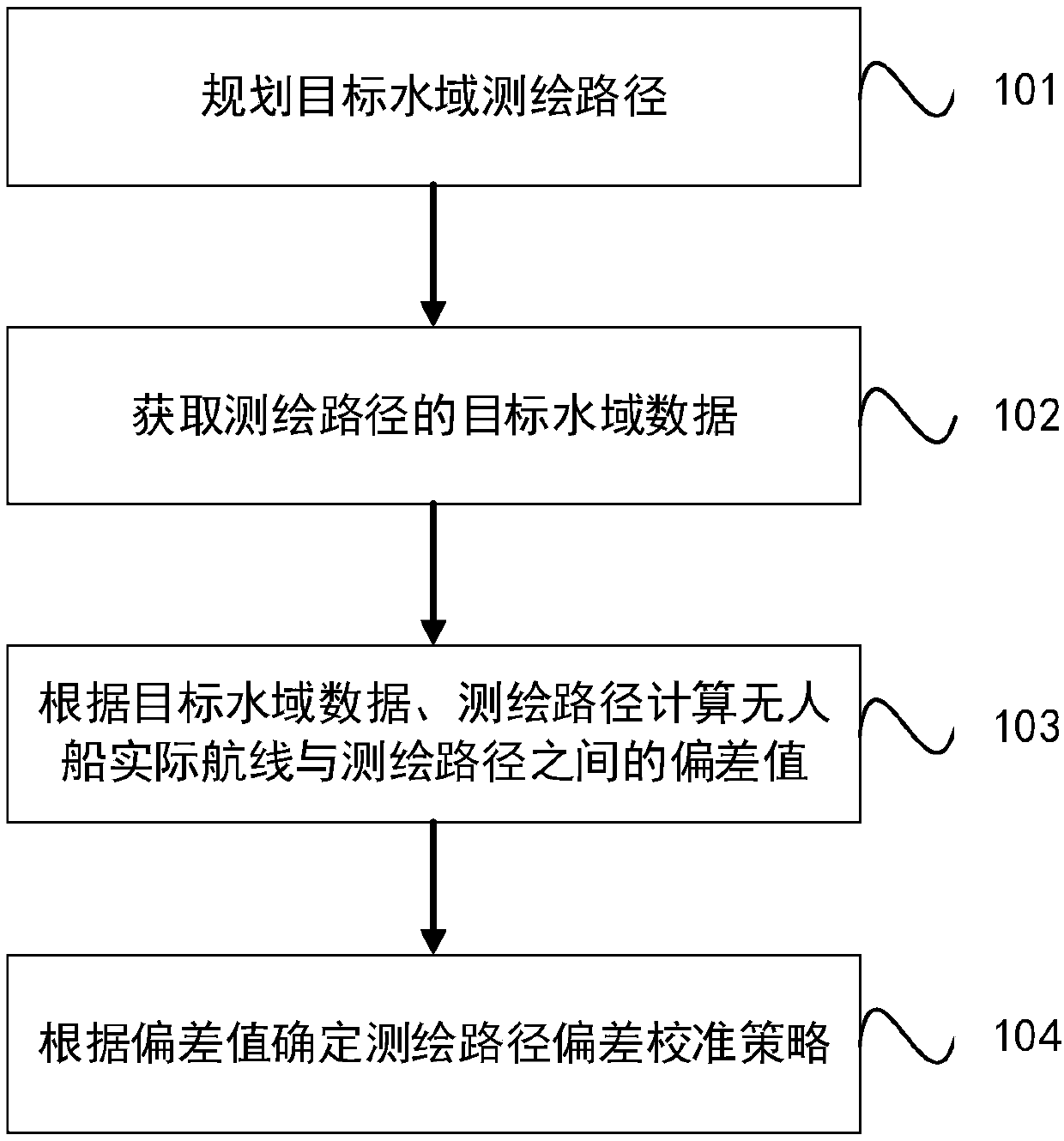
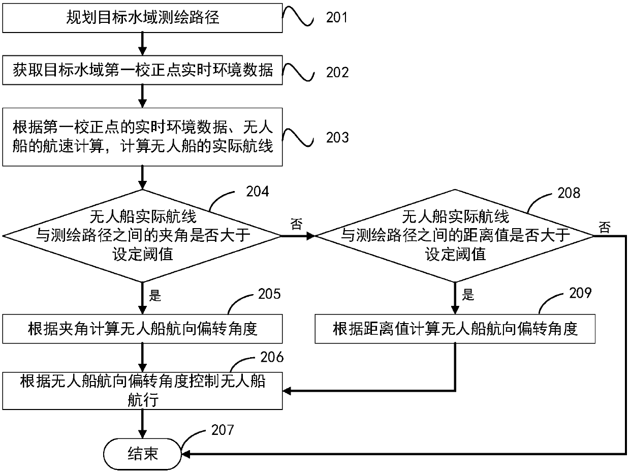
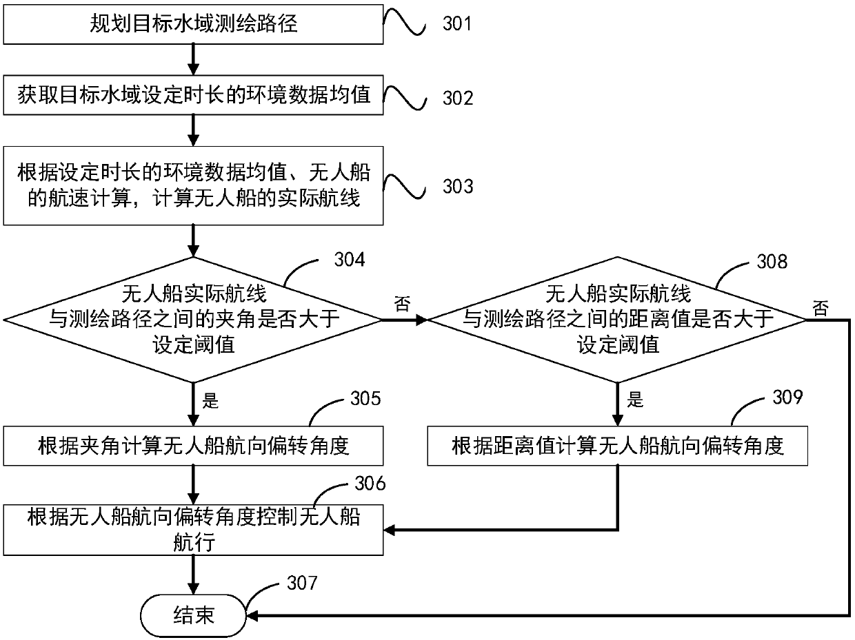
[0040] like figure 1 Shown, be unmanned ship surveying and mapping route calibration method in the embodiment of the present invention, this method comprises:

[0041] Step 101: planning the target water area surveying and mapping route;

[0042] Before the unmanned ship measures the target water area, it is first necessary to plan the surveying path of the target water area to ensure that there is no blank area missing in the target water area.

[0043] Ste...


PUM


Abstract

The invention relates to the technical field of water area environment monitoring, in particular to a path surveying and calibrating method and a system using an unmanned ship, and an unmanned ship. The method comprises: planning the target water area surveying path; acquiring the target water area environment data of the surveying path; calculating a deviation value between the actual route of the unmanned ship and the surveying path according to the target water area environment data and the surveying path; and determining a surveying path deviation calibrating strategy according to the deviation value. According to the path surveying and calibrating method using an unmanned ship, the surveying path can be automatically calibrated according to the planned surveying path and the environment information, so that the accuracy and the reliability of the measurement data are improved.

Description

technical field [0001] The invention relates to the technical field of water area environment monitoring, in particular to a method for calibrating an unmanned vessel surveying and mapping path and an unmanned vessel. Background technique [0002] In traditional water environment monitoring and water surveying and mapping, monitoring sensors or surveying and mapping equipment are installed on surveying ships or marine monitoring ships. The surveyors plan the survey line in advance, and the pilot controls the surveying ship to go online for measurement. With the emergence of new marine surveying and mapping carriers represented by unmanned ships in recent years, the method of using small ships as carriers, carrying a variety of monitoring sensors, and completing the monitoring of specific hydrological and water environment elements in a remote / autonomous working mode is becoming more and more important. more and more attention. [0003] Unmanned ships have the characteristic...

Claims


Application Information

Patent Timeline
Patent Type & Authority Applications(China)
IPC IPC(8): G01C21/00G01C25/00G01C13/00G01W1/02
CPCG01C13/00G01C21/00G01C25/00G01W1/02Y02A90/30
Inventor 程和琴江云华李为华刘涵姜泽宇何正来张文祥滕立志
Owner EAST CHINA NORMAL UNIV
Why Eureka
Try Eureka