Visible light communication based positioning

A visible light communication and positioning signal technology, applied in the field of positioning systems based on visible light communication, can solve the problems of GPS signal loss and inapplicability of full indoor positioning services, etc.

Active Publication Date: 2019-04-16
CENT NAT DETUD SPATIALES (CNES)
View PDF13 Cites 4 Cited by
  • Summary
  • Abstract
  • Description
  • Claims
  • Application Information

AI Technical Summary

Problems solved by technology

This method is not suitable for all indoor positioning services, because the GPS signal may be completely lost

Method used


Image

  • Visible light communication based positioning
  • Visible light communication based positioning
  • Visible light communication based positioning

Examples


Embodiment Construction

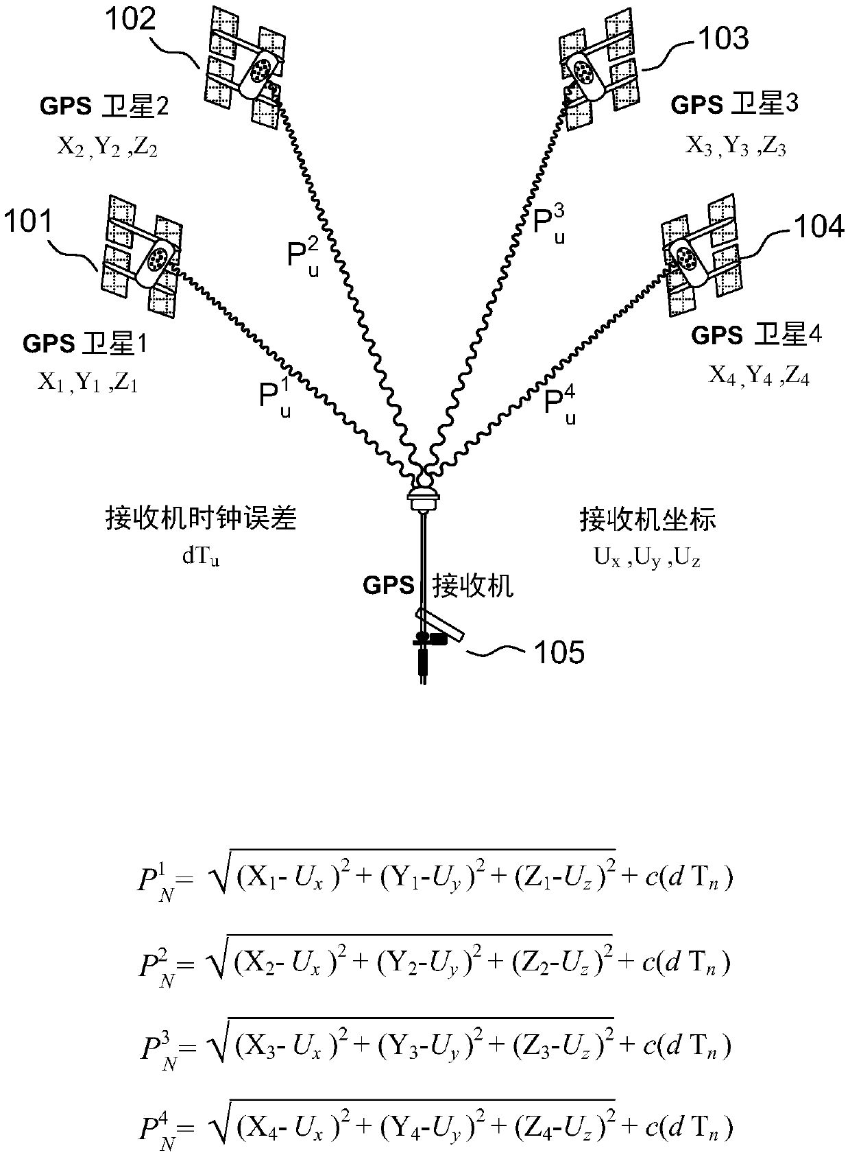
[0048] Figure 1 describes a GNSS communication system according to the prior art. The GNSS system may be GPS, GLONASS, Beidou, Galileo, or may use signals from satellites of one of these constellations.

[0049] In FIG. 1, a plurality of satellites 101, 102, 103, and 104 are transmitting GNSS positioning signals including information about the time of transmission delivered by a high-precision clock embedded in each satellite.

[0050] GNSS receiver 105 includes multiple tracking loops. Each tracking loop correlates a GNSS signal received from one of the satellites with a local copy of the signal, allowing it to determine when the signal was received. Retrieves the sending time of the signal from the navigation message. The time difference between the sending time and the receiving time is then formed. This time difference is called the pseudorange, which is related to the travel time between the satellite and the receiver. It is biased by many phenomena such as Tx and Rx ...


PUM


Abstract

A navigation system using Visible Light Communications (VLC), the associated transmitters and receivers, the navigation system comprising a plurality of VLC transmitters (201 to 207) and one or more GNSS receiver (430), each of the VLC transmitters being configured to transmit a positioning signal comprising a navigation message including time information, where the time information is a transmission time of a specific part of said navigation message derived from a GNSS reference time. The receivers (221) according to the invention are configured to calculate a position from either VLC pseudoranges, GNSS pseudo ranges, or a combination thereof. The associated methods for transmitting positioning signals in a navigation system according to the invention, and for determining a position froma plurality of positioning signals transmitted by said navigation system.

Description

technical field [0001] The invention is applied to the field of positioning systems. More specifically, the present invention describes a positioning system based on visible light communication (VLC). Background technique [0002] Due to the wide variety of applications involved, positioning technology, especially indoor positioning technology, has received more and more attention. These applications include location-based services (LBS) in public places such as shopping malls, stadiums or parking lots, where indoor positioning systems allow the delivery of content that actually matches the user's needs. Among these applications is also machine control, such as the control of robots in warehouses, path-finding applications, augmented reality, and more. In order to be relevant, indoor positioning must be very accurate. [0003] GNSS (acronym for Global Navigation Satellite System) positioning technology has been used and improved for many years. Two global navigation sate...

Claims


Application Information

Patent Timeline
Patent Type & Authority Applications(China)
IPC IPC(8): G01S1/70G01S5/16G01S19/11
CPCG01S5/16G01S19/10G01S2201/01G01S19/11G01S1/7034G01S1/02G01C21/206
Inventor F-X·马尔梅
Owner CENT NAT DETUD SPATIALES (CNES)
Why Eureka
Try Eureka