Laser radar positioning method on basis of scanning line segment coincidence length estimation

A technology of laser radar and positioning method, which is applied in the direction of radio wave measurement systems and instruments, can solve the problems of inaccurate positioning, achieve high robustness, reduce the amount of calculation, and improve timeliness

Active Publication Date: 2019-04-19
NANJING UNIV OF SCI & TECH
View PDF2 Cites 21 Cited by
  • Summary
  • Abstract
  • Description
  • Claims
  • Application Information

AI Technical Summary

Problems solved by technology

[0003] The purpose of the present invention is to provide a laser radar positioning method based on the estimation of the overlapping length of scanning line segments, which overcomes the problem of inaccurate positioning in the absence of complete line segments in the prior art

Method used


Image

  • Laser radar positioning method on basis of scanning line segment coincidence length estimation
  • Laser radar positioning method on basis of scanning line segment coincidence length estimation
  • Laser radar positioning method on basis of scanning line segment coincidence length estimation

Examples


Embodiment Construction

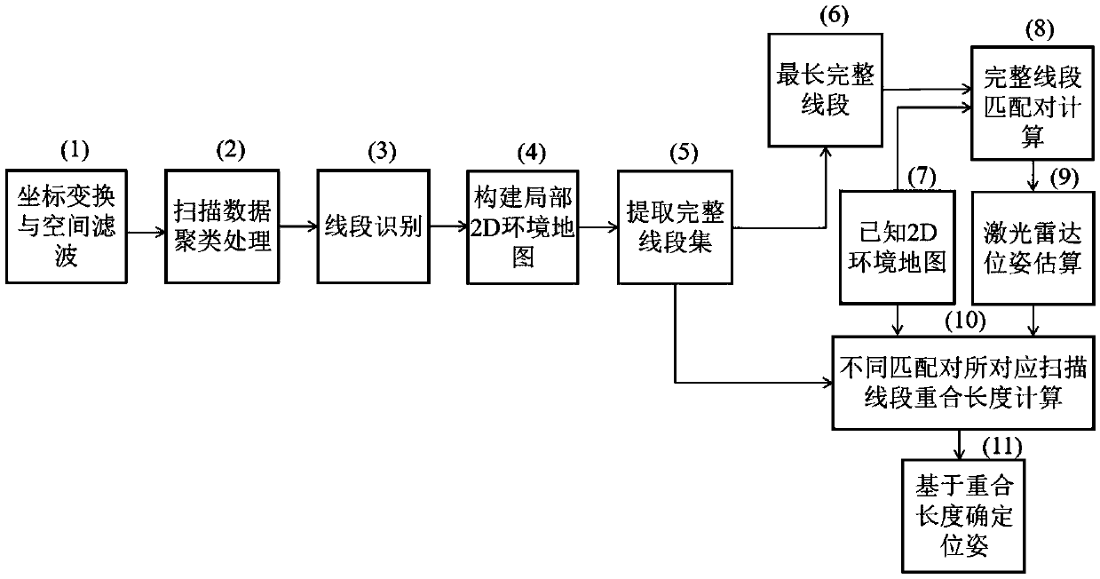
[0015] The solutions of the present invention will be further described below in conjunction with the accompanying drawings and specific embodiments.

[0016] like figure 1 As shown, the lidar positioning method based on the estimation of the coincidence length of scanning line segments includes the following steps:

[0017] Step 1. Perform coordinate transformation and spatial filtering on the raw data scanned by the lidar;

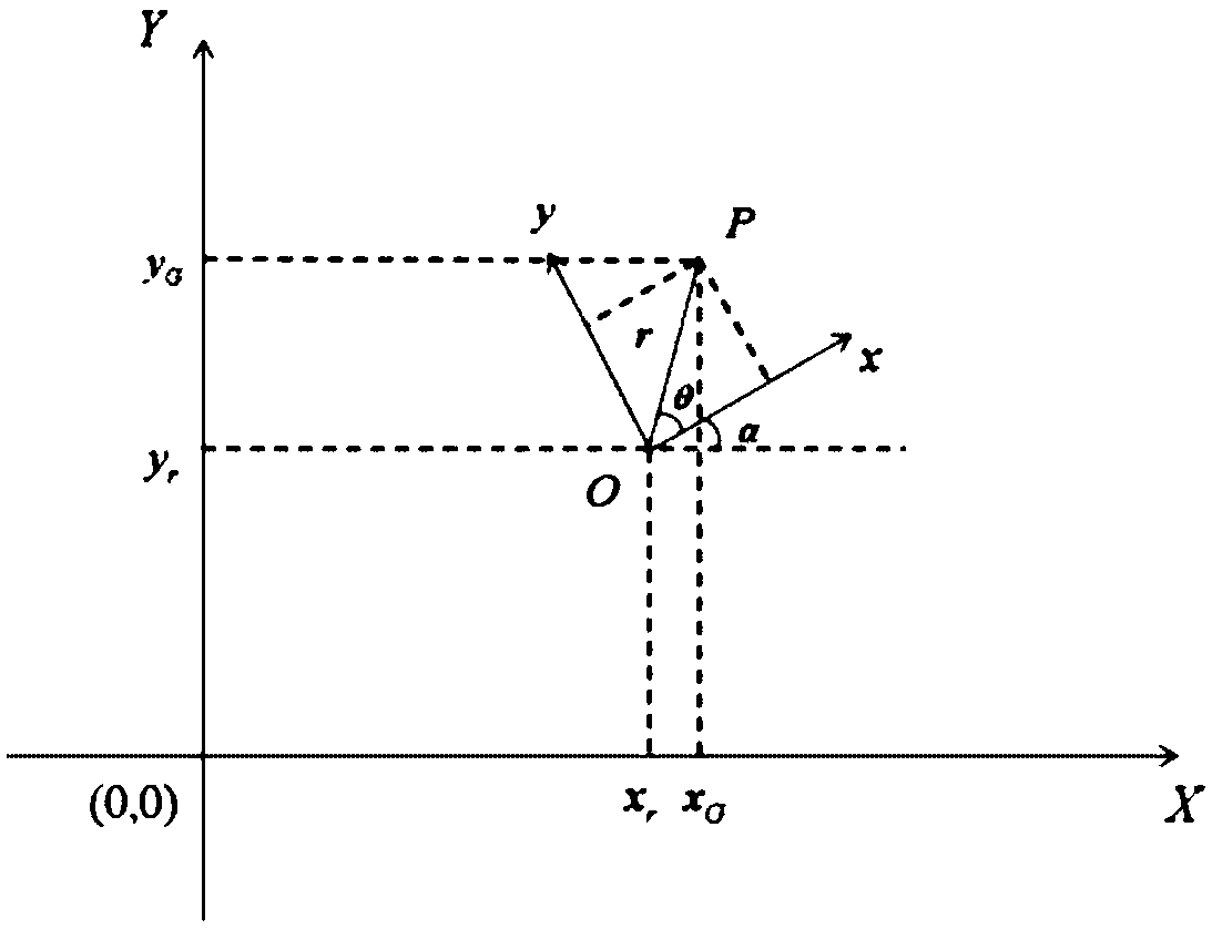
[0018] Coordinate transformation and spatial filtering: The original data points acquired by the single-line lidar are ranging values ​​and corresponding scanning angles, so the data representation is expressed in polar coordinates, that is, in the form of (r, α). For the subsequent environment map construction, the first thing we need to do is to coordinate transform the local raw data acquired by the lidar, and transform its polar coordinates into rectangular coordinates, such as figure 2 The local Cartesian coordinate system of the laser radar is e...


PUM


Abstract

The invention discloses a laser radar positioning method on the basis of scanning line segment coincidence length estimation. The laser radar positioning method includes carrying out coordinate transformation and spatial filtering on single-line laser radar scanning original data; carrying out scanning data clustering processing and line segment identification, and building local 2D (two-dimensional) environmental maps; constructing complete line segment sets, utilizing the lengths of complete line segments as matching parameters, selecting the longest complete line segments and known 2D environmental maps and computing complete line segment matching pairs; ultimately estimating laser radar positions and posture, computing coincidence lengths of scanning line segments corresponding to thedifferent matching pairs and determining positions and posture. The laser radar positioning method has the advantages that the lengths of coincidence line segments of the matched complete line segments are computed, accordingly, the positioning accuracy can be evaluated, the problem of inaccurate positioning under the condition of complete line segment missing can be solved by the aid of the laserradar positioning method, the laser radar positioning method is good in adaptability and high in positioning precision and robustness, and the like.

Description

technical field [0001] The invention relates to a laser radar positioning method, in particular to a laser radar positioning method based on the estimation of overlapping length of scanning line segments. Background technique [0002] Indoor positioning is the most basic link in the autonomous navigation of mobile robots. Existing technologies mostly use complete line segments for indoor positioning, such as the paper "Obstacle Detection and Self-Location of Mobile Robots Based on LiDAR [D]" (Xiang Zhiyu, Zhejiang University, 2002) using LiDAR to obtain complete The line segment is matched with the global graph, and the method has a small amount of calculation and good robustness. However, when evaluating the matching accuracy, the parameters of complete line segments are selected for evaluation, and the insufficient number of complete line segments is not considered, which will lead to inaccurate positioning. The paper "Research on Positioning of Indoor Autonomous Mobile ...

Claims


Application Information

Patent Timeline
Patent Type & Authority Applications(China)
IPC IPC(8): G01S7/48
CPCG01S7/4802
Inventor 来建成邹艾伶李振华王春勇严伟纪运景
Owner NANJING UNIV OF SCI & TECH
Why Eureka
Try Eureka